Saint-Bonnet-près-Riom (Saint-Bonnet-près-Riom)

- commune in Puy-de-Dôme, France
- Country:

- Postal Code: 63200
- Coordinates: 45° 55' 47" N, 3° 6' 47" E


- GPS tracks (wikiloc): [Link]
- Area: 7.03 sq km
- Population: 2124
- Web site: http://www.saint-bonnet-pres-riom.fr
- Wikipedia en: wiki(en)
- Wikipedia: wiki(fr)
- Wikidata storage: Wikidata: Q671932
- Wikipedia Commons Category: [Link]
- Freebase ID: [/m/03ql20b]
- SIREN number: [216303271]
- BnF ID: [15269677v]
- VIAF ID: Alt: [140331635]
- SUDOC authorities ID: [18780012X]
- INSEE municipality code: 63327
Shares border with regions:


Cellule
- former commune in Puy-de-Dôme, France
- Country:
- Postal Code: 63200
- Coordinates: 45° 56' 50" N, 3° 8' 22" E
- GPS tracks (wikiloc): [Link]
- Area: 8.74 sq km
- Population: 1174
- Web site: [Link]


Yssac-la-Tourette
- commune in Puy-de-Dôme, France
- Country:
- Postal Code: 63200
- Coordinates: 45° 56' 6" N, 3° 5' 34" E
- GPS tracks (wikiloc): [Link]
- Area: 2.14 sq km
- Population: 376
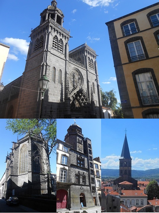
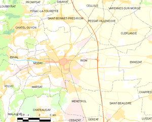
Riom
- commune in Puy-de-Dôme, France
- Country:
- Postal Code: 63200
- Coordinates: 45° 53' 37" N, 3° 6' 45" E
- GPS tracks (wikiloc): [Link]
- AboveSeaLevel: 337 м m
- Area: 31.97 sq km
- Population: 18987
- Web site: [Link]

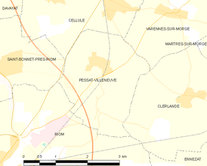
Pessat-Villeneuve
- commune in Puy-de-Dôme, France
- Country:
- Postal Code: 63200
- Coordinates: 45° 55' 42" N, 3° 9' 26" E
- GPS tracks (wikiloc): [Link]
- Area: 6.26 sq km
- Population: 618
- Web site: [Link]


Davayat
- commune in Puy-de-Dôme, France
- Country:
- Postal Code: 63200
- Coordinates: 45° 56' 50" N, 3° 6' 31" E
- GPS tracks (wikiloc): [Link]
- Area: 2.33 sq km
- Population: 596
- Web site: [Link]


Châtel-Guyon
- commune in Puy-de-Dôme, France
- Country:
- Postal Code: 63140
- Coordinates: 45° 55' 21" N, 3° 3' 51" E
- GPS tracks (wikiloc): [Link]
- Area: 14.06 sq km
- Population: 6194
- Web site: [Link]