Saint-Bonnet-sur-Gironde (Saint-Bonnet-sur-Gironde)

- commune in Charente-Maritime, France
- Country:

- Postal Code: 17150
- Coordinates: 45° 21' 16" N, 0° 39' 36" E


- GPS tracks (wikiloc): [Link]
- Area: 30.6 sq km
- Population: 816
- Web site: http://www.saintbonnetsurgironde.com
- Wikipedia en: wiki(en)
- Wikipedia: wiki(fr)
- Wikidata storage: Wikidata: Q1146149
- Wikipedia Commons Category: [Link]
- Freebase ID: [/m/02qcwwq]
- GeoNames ID: Alt: [2981314]
- SIREN number: [211703129]
- BnF ID: [15249173p]
- INSEE municipality code: 17312
Shares border with regions:


Saint-Sorlin-de-Conac
- commune in Charente-Maritime, France
- Country:
- Postal Code: 17150
- Coordinates: 45° 22' 6" N, 0° 40' 44" E
- GPS tracks (wikiloc): [Link]
- Area: 15.37 sq km
- Population: 202

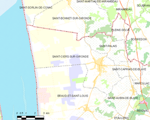
Saint-Ciers-sur-Gironde
- commune in Gironde, France
- Country:
- Postal Code: 33820
- Coordinates: 45° 17' 19" N, 0° 36' 29" E
- GPS tracks (wikiloc): [Link]
- Area: 38.34 sq km
- Population: 3039
- Web site: [Link]


Saint-Palais
- commune in Gironde, France
- Country:
- Postal Code: 33820
- Coordinates: 45° 18' 50" N, 0° 35' 23" E
- GPS tracks (wikiloc): [Link]
- AboveSeaLevel: 60 м m
- Area: 9.76 sq km
- Population: 522


Saint-Georges-des-Agoûts
- commune in Charente-Maritime, France
- Country:
- Postal Code: 17150
- Coordinates: 45° 22' 31" N, 0° 38' 46" E
- GPS tracks (wikiloc): [Link]
- Area: 6.31 sq km
- Population: 277


Mirambeau
- commune in Charente-Maritime, France
- Country:
- Postal Code: 17150
- Coordinates: 45° 22' 24" N, 0° 34' 13" E
- GPS tracks (wikiloc): [Link]
- Area: 26.94 sq km
- Population: 1482
- Web site: [Link]


Saint-Martial-de-Mirambeau
- commune in Charente-Maritime, France
- Country:
- Postal Code: 17150
- Coordinates: 45° 22' 53" N, 0° 35' 35" E
- GPS tracks (wikiloc): [Link]
- Area: 9.08 sq km
- Population: 255
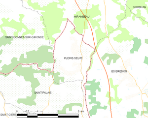
Pleine-Selve
- commune in Gironde, France
- Country:
- Postal Code: 33820
- Coordinates: 45° 19' 39" N, 0° 34' 33" E
- GPS tracks (wikiloc): [Link]
- AboveSeaLevel: 42 м m
- Area: 4.23 sq km
- Population: 221


Semoussac
- commune in Charente-Maritime, France
- Country:
- Postal Code: 17150
- Coordinates: 45° 23' 10" N, 0° 37' 27" E
- GPS tracks (wikiloc): [Link]
- Area: 9.62 sq km
- Population: 323