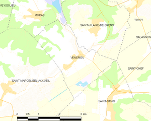
Saint-Hilaire-de-Brens (Saint-Hilaire-de-Brens)

- commune in Isère, France
 Hiking in Saint-Hilaire-de-Brens
Saint-Hilaire-de-Brens, located in the Auvergne-Rhône-Alpes region of France, is a small commune that offers a charming backdrop for hikers. The area is characterized by its beautiful landscapes, including gentle hills, rural countryside, and panoramic views.
Hiking Trails
While Saint-Hilaire-de-Brens may not be as widely known as major hiking destinations, there are some local trails and paths worth exploring:
-
Local Trails: The area features various paths that connect to neighboring communes and the surrounding countryside. These trails often take you through fields, forests, and offer a taste of rural French life.
-
Nearby Nature Reserves: Depending on your interest in wildlife and nature, you can venture to nearby nature reserves or parks where you can find marked trails and more structured hiking tracks.
-
Scenic Views: A typical hike in this area can provide beautiful views of the surrounding landscapes and is ideal for leisurely walks, family hikes, or even more strenuous outdoor activities depending on the trail chosen.
Preparing for Your Hike
- Gear: Ensure you have comfortable hiking shoes, suitable clothing for the weather, and necessary supplies like water, snacks, and a first-aid kit.
- Navigation: While many trails might be well-marked, it's advisable to have a map or GPS device, especially if you're venturing into less familiar areas.
- Weather: The weather can change quickly, so check local forecasts and dress in layers.
Nearby Attractions
If you have extra time, consider exploring:
- Historic Sites: The region has several historic buildings and charming villages that reflect the local history and culture.
- Wine Regions: This area is not far from several renowned wine-producing regions; consider taking a break from hiking to enjoy some local wines.
Conclusion
Hiking in and around Saint-Hilaire-de-Brens can be a rewarding experience for those looking to connect with nature and enjoy peaceful surroundings. Make sure to respect the environment, follow local regulations regarding trail use, and take in the unique beauty of this part of France. Enjoy your hike!
- Country:

- Postal Code: 38460
- Coordinates: 45° 40' 20" N, 5° 17' 28" E


- GPS tracks (wikiloc): [Link]
- Area: 7.52 sq km
- Population: 608
- Wikipedia en: wiki(en)
- Wikipedia: wiki(fr)
- Wikidata storage: Wikidata: Q1068435
- Wikipedia Commons Category: [Link]
- Freebase ID: [/m/03nvhf2]
- GeoNames ID: Alt: [6433345]
- SIREN number: [213803927]
- BnF ID: [15258202d]
- INSEE municipality code: 38392
Shares border with regions:


Dizimieu
- commune in Isère, France
Hiking in Dizimieu
Dizimieu is a picturesque village located in the Isère department in the Auvergne-Rhône-Alpes region of France. The surrounding area features beautiful natural landscapes, making it a great location for hiking enthusiasts. Here are some key points to know about hiking in and around Dizimieu:...
- Country:
- Postal Code: 38460
- Coordinates: 45° 43' 6" N, 5° 17' 55" E
- GPS tracks (wikiloc): [Link]
- Area: 9.74 sq km
- Population: 836
- Web site: [Link]

Vénérieu
- commune in Isère, France
Hiking in Vénérieu
Vénérieu is a small commune located in the Isère department of the Auvergne-Rhône-Alpes region in southeastern France. While it may not be as famous as other hiking destinations, it can offer some charming walking and hiking opportunities, especially for those looking to explore the lesser-known paths of the French countryside....
- Country:
- Postal Code: 38460
- Coordinates: 45° 39' 33" N, 5° 16' 39" E
- GPS tracks (wikiloc): [Link]
- Area: 6 sq km
- Population: 753
- Web site: [Link]


Trept
- commune in Isère, France
Hiking in Trept
Trept is a scenic area located in the eastern part of Germany, particularly known for its beautiful landscapes and walking trails. While it may not be as famous as some other hiking destinations in Germany, there are still plenty of opportunities for outdoor enthusiasts to explore nature and enjoy some hiking....
- Country:
- Postal Code: 38460
- Coordinates: 45° 41' 12" N, 5° 19' 12" E
- GPS tracks (wikiloc): [Link]
- Area: 15.87 sq km
- Population: 2024
- Web site: [Link]


Moras
- commune in Isère, France
Hiking in Moras
Moras, a scenic area, offers a variety of hiking opportunities for outdoor enthusiasts. Whether you’re a beginner or an experienced hiker, you’ll find trails that suit your skill level and preferences. Here are some general things to consider about hiking in Moras:...
- Country:
- Postal Code: 38460
- Coordinates: 45° 41' 14" N, 5° 15' 30" E
- GPS tracks (wikiloc): [Link]
- AboveSeaLevel: 345 м m
- Area: 8.32 sq km
- Population: 503
- Web site: [Link]


Saint-Chef
- commune in Isère, France
Hiking in Saint-Chef
Saint-Chef is a charming commune located in the Isère department of the Auvergne-Rhône-Alpes region in southeastern France. The area is known for its beautiful landscapes, rolling hills, and rich natural surroundings, making it an attractive destination for hikers of all levels....
- Country:
- Postal Code: 38890
- Coordinates: 45° 38' 2" N, 5° 21' 57" E
- GPS tracks (wikiloc): [Link]
- Area: 27.16 sq km
- Population: 3620
- Web site: [Link]