Saint-Jammes (Saint-Jammes)

- commune in Pyrénées-Atlantiques, France
- Country:

- Postal Code: 64160
- Coordinates: 43° 21' 33" N, 0° 14' 37" E


- GPS tracks (wikiloc): [Link]
- Area: 4.05 sq km
- Population: 648
- Web site: http://www.mairiedesaintjammes.fr
- Wikipedia en: wiki(en)
- Wikipedia: wiki(fr)
- Wikidata storage: Wikidata: Q860637
- Wikipedia Commons Category: [Link]
- Freebase ID: [/m/03qlzpq]
- Freebase ID: [/m/03qlzpq]
- GeoNames ID: Alt: [2979399]
- GeoNames ID: Alt: [2979399]
- SIREN number: [216404822]
- SIREN number: [216404822]
- BnF ID: [15270304v]
- BnF ID: [15270304v]
- INSEE municipality code: 64482
- INSEE municipality code: 64482
Shares border with regions:


Higuères-Souye
- commune in Pyrénées-Atlantiques, France
- Country:
- Postal Code: 64160
- Coordinates: 43° 22' 41" N, 0° 15' 35" E
- GPS tracks (wikiloc): [Link]
- Area: 7.35 sq km
- Population: 280


Maucor
- commune in Pyrénées-Atlantiques, France
- Country:
- Postal Code: 64160
- Coordinates: 43° 21' 17" N, 0° 17' 1" E
- GPS tracks (wikiloc): [Link]
- Area: 4.92 sq km
- Population: 495


Morlaàs
- commune in Pyrénées-Atlantiques, France
- Country:
- Postal Code: 64160
- Coordinates: 43° 20' 40" N, 0° 15' 45" E
- GPS tracks (wikiloc): [Link]
- Area: 13.15 sq km
- Population: 4156
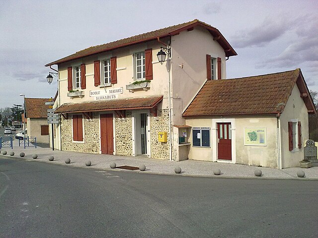

Bernadets
- commune in Pyrénées-Atlantiques, France
- Country:
- Postal Code: 64160
- Coordinates: 43° 23' 0" N, 0° 17' 0" E
- GPS tracks (wikiloc): [Link]
- Area: 3.68 sq km
- Population: 580
- Web site: [Link]

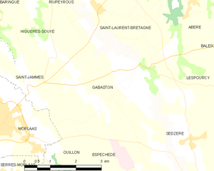
Gabaston
- commune in Pyrénées-Atlantiques, France
- Country:
- Postal Code: 64160
- Coordinates: 43° 21' 36" N, 0° 12' 30" E
- GPS tracks (wikiloc): [Link]
- Area: 12.73 sq km
- Population: 647