Saint-Léonard-de-Noblat (Saint-Léonard-de-Noblat)

- commune in Haute-Vienne, France
- Country:

- Postal Code: 87400
- Coordinates: 45° 50' 15" N, 1° 29' 26" E


- GPS tracks (wikiloc): [Link]
- Area: 55.59 sq km
- Population: 4633
- Web site: http://www.ville-saint-leonard.fr
- Wikipedia en: wiki(en)
- Wikipedia: wiki(fr)
- Wikidata storage: Wikidata: Q200202
- Wikipedia Commons Category: [Link]
- Freebase ID: [/m/06zv2_]
- GeoNames ID: Alt: [2978782]
- SIREN number: [218716108]
- BnF ID: [15278884n]
- VIAF ID: Alt: [154666099]
- Library of Congress authority ID: Alt: [n88649679]
- MusicBrainz area ID: [00fa99f4-64da-4708-90d9-18ddfd45e1a1]
- INSEE municipality code: 87161
Shares border with regions:
Champnétery
- commune in Haute-Vienne, France
- Country:
- Postal Code: 87400
- Coordinates: 45° 49' 55" N, 1° 34' 19" E
- GPS tracks (wikiloc): [Link]
- Area: 30.6 sq km
- Population: 553
Moissannes
- commune in Haute-Vienne, France
- Country:
- Postal Code: 87400
- Coordinates: 45° 52' 30" N, 1° 33' 54" E
- GPS tracks (wikiloc): [Link]
- Area: 24.64 sq km
- Population: 401

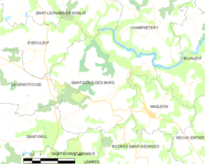
Saint-Denis-des-Murs
- commune in Haute-Vienne, France
- Country:
- Postal Code: 87400
- Coordinates: 45° 47' 7" N, 1° 32' 40" E
- GPS tracks (wikiloc): [Link]
- Area: 23.81 sq km
- Population: 527

Le Châtenet-en-Dognon
- commune in Haute-Vienne, France
- Country:
- Postal Code: 87400
- Coordinates: 45° 54' 21" N, 1° 30' 22" E
- GPS tracks (wikiloc): [Link]
- Area: 20.39 sq km
- Population: 402


Eybouleuf
- commune in Haute-Vienne, France
- Country:
- Postal Code: 87400
- Coordinates: 45° 47' 43" N, 1° 28' 56" E
- GPS tracks (wikiloc): [Link]
- Area: 10.83 sq km
- Population: 428


Royères
- commune in Haute-Vienne, France
- Country:
- Postal Code: 87400
- Coordinates: 45° 50' 55" N, 1° 25' 49" E
- GPS tracks (wikiloc): [Link]
- Area: 17.42 sq km
- Population: 866

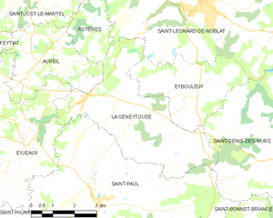
La Geneytouse
- commune in Haute-Vienne, France
- Country:
- Postal Code: 87400
- Coordinates: 45° 47' 7" N, 1° 28' 2" E
- GPS tracks (wikiloc): [Link]
- Area: 19.35 sq km
- Population: 909
- Web site: [Link]