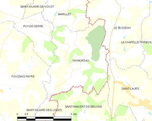
Saint-Maixent-de-Beugné (Saint-Maixent-de-Beugné)

- commune in Deux-Sèvres, France
- Country:

- Postal Code: 79160
- Coordinates: 46° 30' 17" N, 0° 36' 33" E


- GPS tracks (wikiloc): [Link]
- Area: 11.02 sq km
- Population: 395
- Wikipedia en: wiki(en)
- Wikipedia: wiki(fr)
- Wikidata storage: Wikidata: Q596809
- Wikipedia Commons Category: [Link]
- Freebase ID: [/m/08_046]
- GeoNames ID: Alt: [6444211]
- SIREN number: [217902691]
- BnF ID: [152764037]
- INSEE municipality code: 79269
Shares border with regions:

Faymoreau
- commune in Vendée, France
- Country:
- Postal Code: 85240
- Coordinates: 46° 33' 12" N, 0° 37' 40" E
- GPS tracks (wikiloc): [Link]
- Area: 10.99 sq km
- Population: 214

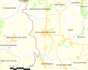
Coulonges-sur-l'Autize
- commune in Deux-Sèvres, France
- Country:
- Postal Code: 79160
- Coordinates: 46° 29' 0" N, 0° 35' 57" E
- GPS tracks (wikiloc): [Link]
- Area: 18.87 sq km
- Population: 2363
- Web site: [Link]

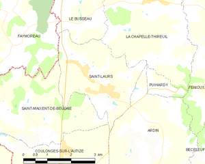
Saint-Laurs
- commune in Deux-Sèvres, France
- Country:
- Postal Code: 79160
- Coordinates: 46° 31' 31" N, 0° 35' 2" E
- GPS tracks (wikiloc): [Link]
- Area: 8.14 sq km
- Population: 561


Saint-Hilaire-des-Loges
- commune in Vendée, France
- Country:
- Postal Code: 85240
- Coordinates: 46° 28' 18" N, 0° 39' 54" E
- GPS tracks (wikiloc): [Link]
- Area: 35.2 sq km
- Population: 1961
- Web site: [Link]