Saint-Michel-de-Double (Saint-Michel-de-Double)
- commune in Dordogne, France
- Country:

- Postal Code: 24400
- Coordinates: 45° 4' 47" N, 0° 17' 21" E


- GPS tracks (wikiloc): [Link]
- Area: 29.48 sq km
- Population: 244
- Wikipedia en: wiki(en)
- Wikipedia: wiki(fr)
- Wikidata storage: Wikidata: Q1076529
- Wikipedia Commons Category: [Link]
- Freebase ID: [/m/03mg9gt]
- Freebase ID: [/m/03mg9gt]
- GeoNames ID: Alt: [2977995]
- GeoNames ID: Alt: [2977995]
- SIREN number: [212404651]
- SIREN number: [212404651]
- BnF ID: [15252108r]
- BnF ID: [15252108r]
- INSEE municipality code: 24465
- INSEE municipality code: 24465
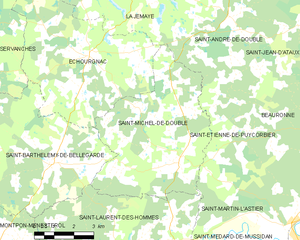
Shares border with regions:


Échourgnac
- commune in Dordogne, France
- Country:

- Postal Code: 24410
- Coordinates: 45° 7' 32" N, 0° 13' 49" E


- GPS tracks (wikiloc): [Link]
- Area: 34.88 sq km
- Population: 401


La Jemaye
- former commune in Dordogne, France
- Country:

- Postal Code: 24410
- Coordinates: 45° 10' 12" N, 0° 15' 28" E


- GPS tracks (wikiloc): [Link]
- Area: 29.12 sq km
- Population: 109


Saint-Martin-l'Astier
- commune in Dordogne, France
- Country:

- Postal Code: 24400
- Coordinates: 45° 3' 22" N, 0° 19' 45" E


- GPS tracks (wikiloc): [Link]
- Area: 9.4 sq km
- Population: 139
- Web site: [Link]

Saint-André-de-Double
- commune in Dordogne, France
- Country:

- Postal Code: 24190
- Coordinates: 45° 8' 45" N, 0° 19' 5" E


- GPS tracks (wikiloc): [Link]
- Area: 27.61 sq km
- Population: 168
- Web site: [Link]


Saint-Étienne-de-Puycorbier
- commune in Dordogne, France
- Country:

- Postal Code: 24400
- Coordinates: 45° 5' 33" N, 0° 19' 46" E


- GPS tracks (wikiloc): [Link]
- Area: 13.54 sq km
- Population: 112


Saint-Laurent-des-Hommes
- commune in Dordogne, France
- Country:

- Postal Code: 24400
- Coordinates: 45° 2' 15" N, 0° 15' 12" E


- GPS tracks (wikiloc): [Link]
- Area: 31.94 sq km
- Population: 1025
- Web site: [Link]


Saint-Barthélemy-de-Bellegarde
- commune in Dordogne, France
- Country:

- Postal Code: 24700
- Coordinates: 45° 4' 40" N, 0° 12' 37" E


- GPS tracks (wikiloc): [Link]
- AboveSeaLevel: 124 м m
- Area: 33.12 sq km
- Population: 515
- Web site: [Link]
