Saint-Pavace (Saint-Pavace)

- commune in Sarthe, France
- Country:

- Postal Code: 72190
- Coordinates: 48° 2' 18" N, 0° 11' 16" E


- GPS tracks (wikiloc): [Link]
- Area: 5.16 sq km
- Population: 1932
- Web site: http://www.saint-pavace.fr
- Wikipedia en: wiki(en)
- Wikipedia: wiki(fr)
- Wikidata storage: Wikidata: Q672491
- Wikipedia Commons Category: [Link]
- Freebase ID: [/m/03qj15c]
- GeoNames ID: Alt: [6617565]
- SIREN number: [217203108]
- BnF ID: [152738624]
- INSEE municipality code: 72310
Shares border with regions:
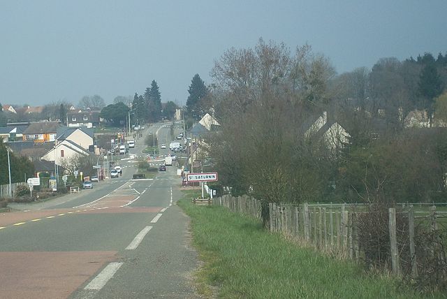
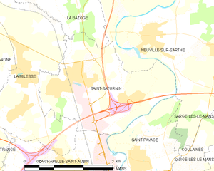
Saint-Saturnin
- commune in Sarthe, France
- Country:
- Postal Code: 72650
- Coordinates: 48° 3' 27" N, 0° 9' 4" E
- GPS tracks (wikiloc): [Link]
- Area: 9.66 sq km
- Population: 2487
- Web site: [Link]


La Chapelle-Saint-Aubin
- commune in Sarthe, France
- Country:
- Postal Code: 72650
- Coordinates: 48° 2' 7" N, 0° 9' 38" E
- GPS tracks (wikiloc): [Link]
- Area: 5.93 sq km
- Population: 2398

Le Mans
- commune in Sarthe, France
- Country:
- Postal Code: 72100; 72000
- Coordinates: 48° 0' 15" N, 0° 11' 49" E
- GPS tracks (wikiloc): [Link]
- AboveSeaLevel: 51 м m
- Area: 52.81 sq km
- Population: 143325
- Web site: [Link]


Coulaines
- commune in Sarthe, France
- Country:
- Postal Code: 72190
- Coordinates: 48° 1' 36" N, 0° 12' 15" E
- GPS tracks (wikiloc): [Link]
- Area: 3.93 sq km
- Population: 7464
- Web site: [Link]


Neuville-sur-Sarthe
- commune in Sarthe, France
- Country:
- Postal Code: 72190
- Coordinates: 48° 4' 33" N, 0° 11' 27" E
- GPS tracks (wikiloc): [Link]
- Area: 22.94 sq km
- Population: 2396
- Web site: [Link]