Saint-Vert (Saint-Vert)

- commune in Haute-Loire, France
- Country:

- Postal Code: 43440
- Coordinates: 45° 22' 18" N, 3° 31' 55" E


- GPS tracks (wikiloc): [Link]
- Area: 20.67 sq km
- Population: 112
- Wikipedia en: wiki(en)
- Wikipedia: wiki(fr)
- Wikidata storage: Wikidata: Q264801
- Wikipedia Commons Category: [Link]
- Freebase ID: [/m/03ntpgd]
- GeoNames ID: Alt: [6434446]
- SIREN number: [214302267]
- BnF ID: [15260130n]
- INSEE municipality code: 43226
Shares border with regions:

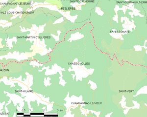
Chassignolles
- commune in Haute-Loire, France
- Country:
- Postal Code: 43440
- Coordinates: 45° 23' 49" N, 3° 29' 32" E
- GPS tracks (wikiloc): [Link]
- Area: 18.27 sq km
- Population: 66
- Web site: [Link]


Laval-sur-Doulon
- commune in Haute-Loire, France
- Country:
- Postal Code: 43440
- Coordinates: 45° 21' 6" N, 3° 33' 41" E
- GPS tracks (wikiloc): [Link]
- Area: 12.28 sq km
- Population: 64


Fayet-Ronaye
- commune in Puy-de-Dôme, France
- Country:
- Postal Code: 63630
- Coordinates: 45° 25' 31" N, 3° 32' 9" E
- GPS tracks (wikiloc): [Link]
- Area: 20.25 sq km
- Population: 104
Doranges
- commune in Puy-de-Dôme, France
- Country:
- Postal Code: 63220
- Coordinates: 45° 24' 25" N, 3° 36' 57" E
- GPS tracks (wikiloc): [Link]
- Area: 19.43 sq km
- Population: 152


Champagnac-le-Vieux
- commune in Haute-Loire, France
- Country:
- Postal Code: 43440
- Coordinates: 45° 21' 28" N, 3° 30' 10" E
- GPS tracks (wikiloc): [Link]
- Area: 20.61 sq km
- Population: 212