Sainte-Gauburge-Sainte-Colombe (Sainte-Gauburge-Sainte-Colombe)

- commune in Orne, France
- Country:

- Postal Code: 61370
- Coordinates: 48° 42' 52" N, 0° 25' 49" E


- GPS tracks (wikiloc): [Link]
- AboveSeaLevel: 246 м m
- Area: 21.17 sq km
- Population: 1060
- Wikipedia en: wiki(en)
- Wikipedia: wiki(fr)
- Wikidata storage: Wikidata: Q1410495
- Wikipedia Commons Category: [Link]
- Freebase ID: [/m/03x_xsv]
- Freebase ID: [/m/03x_xsv]
- GeoNames ID: Alt: [2980581]
- GeoNames ID: Alt: [2980581]
- SIREN number: [216103895]
- SIREN number: [216103895]
- BnF ID: [15268319m]
- BnF ID: [15268319m]
- VIAF ID: Alt: [123604640]
- VIAF ID: Alt: [123604640]
- GND ID: Alt: [4700670-5]
- GND ID: Alt: [4700670-5]
- Library of Congress authority ID: Alt: [nr92024058]
- Library of Congress authority ID: Alt: [nr92024058]
- INSEE municipality code: 61389
- INSEE municipality code: 61389
Shares border with regions:

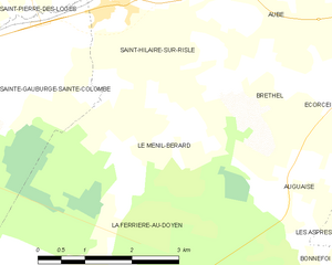
Le Ménil-Bérard
- commune in Orne, France
- Country:
- Postal Code: 61270
- Coordinates: 48° 42' 34" N, 0° 30' 41" E
- GPS tracks (wikiloc): [Link]
- Area: 7.33 sq km
- Population: 76

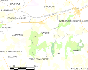
Planches
- commune in Orne, France
- Country:
- Postal Code: 61370
- Coordinates: 48° 42' 6" N, 0° 22' 13" E
- GPS tracks (wikiloc): [Link]
- Area: 12.49 sq km
- Population: 196


La Ferrière-au-Doyen
- commune in Orne, France
- Country:
- Postal Code: 61380
- Coordinates: 48° 39' 50" N, 0° 29' 56" E
- GPS tracks (wikiloc): [Link]
- Area: 22.47 sq km
- Population: 176
- Web site: [Link]


Saint-Hilaire-sur-Risle
- commune in Orne, France
- Country:
- Postal Code: 61270
- Coordinates: 48° 43' 55" N, 0° 29' 41" E
- GPS tracks (wikiloc): [Link]
- Area: 6.61 sq km
- Population: 318


Saint-Pierre-des-Loges
- commune in Orne, France
- Country:
- Postal Code: 61370
- Coordinates: 48° 45' 1" N, 0° 28' 18" E
- GPS tracks (wikiloc): [Link]
- Area: 9.79 sq km
- Population: 162


Échauffour
- commune in Orne, France
- Country:
- Postal Code: 61370
- Coordinates: 48° 44' 27" N, 0° 23' 16" E
- GPS tracks (wikiloc): [Link]
- Area: 33.14 sq km
- Population: 744


Mahéru
- commune in Orne, France
- Country:
- Postal Code: 61380
- Coordinates: 48° 39' 26" N, 0° 25' 55" E
- GPS tracks (wikiloc): [Link]
- Area: 19.63 sq km
- Population: 259


Fay
- commune in Orne, France
- Country:
- Postal Code: 61390
- Coordinates: 48° 39' 34" N, 0° 24' 30" E
- GPS tracks (wikiloc): [Link]
- Area: 8.68 sq km
- Population: 71