Sainte-Sévère (Sainte-Sévère)

- commune in Charente, France
- Country:

- Postal Code: 16200
- Coordinates: 45° 45' 10" N, 0° 14' 20" E


- GPS tracks (wikiloc): [Link]
- Area: 18.31 sq km
- Population: 541
- Web site: http://www.sainte-severe.fr
- Wikipedia en: wiki(en)
- Wikipedia: wiki(fr)
- Wikidata storage: Wikidata: Q567909
- Wikipedia Commons Category: [Link]
- Freebase ID: [/m/03mcd8w]
- GeoNames ID: Alt: [6427852]
- SIREN number: [211603493]
- BnF ID: [15248786f]
- VIAF ID: Alt: [242329564]
- INSEE municipality code: 16349
Shares border with regions:


Réparsac
- commune in Charente, France
- Country:
- Postal Code: 16200
- Coordinates: 45° 43' 47" N, 0° 14' 12" E
- GPS tracks (wikiloc): [Link]
- Area: 11.06 sq km
- Population: 629


Bréville
- commune in Charente, France
- Country:
- Postal Code: 16370
- Coordinates: 45° 47' 47" N, 0° 15' 44" E
- GPS tracks (wikiloc): [Link]
- Area: 15.39 sq km
- Population: 503
- Web site: [Link]


Ballans
- commune in Charente-Maritime, France
- Country:
- Postal Code: 17160
- Coordinates: 45° 48' 50" N, 0° 13' 16" E
- GPS tracks (wikiloc): [Link]
- Area: 6.94 sq km
- Population: 206


Cherves-Richemont
- commune in Charente, France
- Country:
- Postal Code: 16370
- Coordinates: 45° 44' 36" N, 0° 21' 11" E
- GPS tracks (wikiloc): [Link]
- AboveSeaLevel: 28 м m
- Area: 37.94 sq km
- Population: 2437
- Web site: [Link]

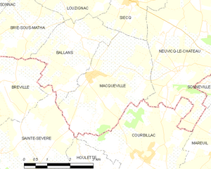
Macqueville
- commune in Charente-Maritime, France
- Country:
- Postal Code: 17490
- Coordinates: 45° 47' 58" N, 0° 12' 50" E
- GPS tracks (wikiloc): [Link]
- Area: 11.21 sq km
- Population: 290

Houlette
- commune in Charente, France
- Country:
- Postal Code: 16200
- Coordinates: 45° 45' 38" N, 0° 12' 44" E
- GPS tracks (wikiloc): [Link]
- Area: 7.15 sq km
- Population: 373