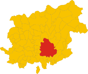
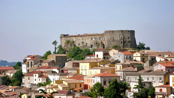
Sant'Angelo a Cupolo (Sant'Angelo a Cupolo)
.svg)
- Italian comune
 Hiking in Sant'Angelo a Cupolo
Sant'Angelo a Cupolo is a small town located in the Campania region of Italy, near Benevento. The area is characterized by its picturesque landscapes, rolling hills, and historical sites, making it a great location for hiking enthusiasts.
Hiking Trails
-
Local Paths: There are various trails that wind through the surrounding hills and woodlands, providing opportunities to explore the local flora and fauna. Look for paths that lead to scenic viewpoints overlooking the Valle Telesina and other nearby natural features.
-
Sentiero del Vino: If you're interested in experiencing the local culture while hiking, consider the "Sentiero del Vino" (Wine Path). This route takes you through vineyards and offers a chance to sample local wines while enjoying the beautiful countryside.
-
Nature Reserves: Nearby natural reserves, such as the local version of the Matese Regional Park, offer more structured hiking trails. These reserves provide a chance to see diverse wildlife and the natural beauty unique to the Apennines.
Tips for Hiking in Sant'Angelo a Cupolo
-
Weather Awareness: The weather can change rapidly, especially in the hills. Be sure to check forecasts and dress in layers.
-
Navigation: While some trails are well-marked, it’s always a good idea to have a map or a GPS app to navigate unfamiliar paths.
-
Stay Hydrated: Carry enough water, especially during warmer months, as some trails may not have sources of fresh water.
-
Local Advice: Don’t hesitate to ask locals for recommendations. They can provide insights on the best trails and any hidden gems in the area.
-
Respect Nature: Follow the "Leave No Trace" principles to help preserve the beauty of the environment.
Attractions
While hiking, you may also be interested in visiting some local attractions, such as:
-
Historical Sites: Check out churches and old buildings in the town itself, which offer a glimpse into the region's history.
-
Culinary Delights: After a day of hiking, treat yourself to local cuisine in one of the nearby trattorias, where you can savor the flavors of Campania.
With its natural beauty and cultural richness, Sant'Angelo a Cupolo presents a wonderful setting for both casual and experienced hikers alike. Enjoy your adventures!
- Country:

- Postal Code: 82010
- Local Dialing Code: 0824
- Licence Plate Code: BN
- Coordinates: 41° 4' 0" N, 14° 48' 0" E


- GPS tracks (wikiloc): [Link]
- AboveSeaLevel: 459 м m
- Area: 11.01 sq km
- Population: 4300
- Web site: http://www.comune.santangeloacupolo.bn.it
- Wikipedia en: wiki(en)
- Wikipedia: wiki(it)
- Wikidata storage: Wikidata: Q55977
- Wikipedia Commons Category: [Link]
- Freebase ID: [/m/0gn2kd]
- GeoNames ID: Alt: [6543279]
- OSM relation ID: [41069]
- ISTAT ID: 062071
- Italian cadastre code: I277
Shares border with regions:

Benevento
- Italian comune
Hiking in Benevento
Benevento, located in the Campania region of Italy, is an excellent destination for hiking enthusiasts, offering a mix of natural beauty, historical sites, and diverse trails suitable for different skill levels. Here are some highlights of hiking in and around Benevento:...
- Country:
- Postal Code: 82100
- Local Dialing Code: 0824
- Licence Plate Code: BN
- Coordinates: 41° 8' 0" N, 14° 47' 0" E
- GPS tracks (wikiloc): [Link]
- AboveSeaLevel: 135 м m
- Area: 129 sq km
- Population: 59789
- Web site: [Link]
Chianche
- Italian comune
Hiking in Chianche
Chianche is a small town located in the Campania region of Italy, known for its beautiful landscapes and proximity to the rolling hills of the Irpinia area. While it may not be as widely known for hiking as some other regions in Italy, there are still some interesting outdoor opportunities in and around Chianche for those who enjoy nature and exploring on foot....
- Country:
- Postal Code: 83010
- Local Dialing Code: 0825
- Licence Plate Code: AV
- Coordinates: 41° 2' 47" N, 14° 47' 21" E
- GPS tracks (wikiloc): [Link]
- AboveSeaLevel: 356 м m
- Area: 6.61 sq km
- Population: 487
- Web site: [Link]

Ceppaloni
- Italian comune
Hiking in Ceppaloni
Ceppaloni is a charming town located in the Campania region of southern Italy, near Benevento. While it may not be as well-known as some of Italy's larger hiking destinations, the surrounding landscape offers beautiful trails and outdoor opportunities....
- Country:
- Postal Code: 82010
- Local Dialing Code: 0824
- Licence Plate Code: BN
- Coordinates: 41° 3' 0" N, 14° 46' 0" E
- GPS tracks (wikiloc): [Link]
- AboveSeaLevel: 368 м m
- Area: 23.8 sq km
- Population: 3370
- Web site: [Link]
San Leucio del Sannio
- Italian comune
Hiking in San Leucio del Sannio
San Leucio del Sannio is a picturesque village located in the Campania region of southern Italy, near the city of Benevento. It offers a variety of hiking opportunities for outdoor enthusiasts, featuring beautiful landscapes, historical sites, and a pleasant climate....
- Country:
- Postal Code: 82010
- Local Dialing Code: 0824
- Licence Plate Code: BN
- Coordinates: 41° 5' 0" N, 14° 46' 0" E
- GPS tracks (wikiloc): [Link]
- AboveSeaLevel: 344 м m
- Area: 9.96 sq km
- Population: 3096
- Web site: [Link]
San Martino Sannita
- Italian comune
Hiking in San Martino Sannita
San Martino Sannita, located in the Campania region of Italy, offers beautiful hiking opportunities, particularly due to its picturesque landscapes and proximity to the Matese Regional Park. Here are some points to consider:...
- Country:
- Postal Code: 82010
- Local Dialing Code: 0824
- Licence Plate Code: BN
- Coordinates: 41° 4' 0" N, 14° 50' 0" E
- GPS tracks (wikiloc): [Link]
- AboveSeaLevel: 450 м m
- Area: 6.18 sq km
- Population: 1265
- Web site: [Link]
San Nicola Manfredi
- Italian comune
Hiking in San Nicola Manfredi
San Nicola Manfredi is a picturesque town located in the Campania region of Italy, near Benevento. While it may not be as widely recognized as some other hiking destinations, it offers access to beautiful landscapes and trails that appeal to outdoor enthusiasts....
- Country:
- Postal Code: 82010
- Local Dialing Code: 0824
- Licence Plate Code: BN
- Coordinates: 41° 4' 0" N, 14° 49' 0" E
- GPS tracks (wikiloc): [Link]
- AboveSeaLevel: 450 м m
- Area: 19.22 sq km
- Population: 3702
- Web site: [Link]