Scharten (Scharten)
- municipality in Austria
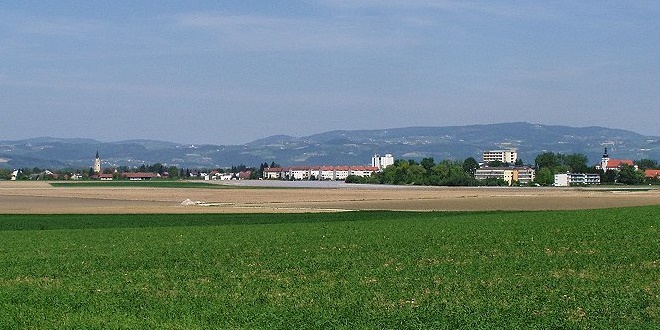
Scharten is a picturesque area located in Austria, near the town of Linz, and offers several hiking trails that cater to various skill levels. Here are some highlights and tips for hiking in Scharten:
Hiking Trails
- Schartener Wald: This forested area has several trails that meander through beautiful woodlands and offer opportunities to see local wildlife.
- Panoramaweg: A scenic trail that provides stunning views of the surrounding hills and valleys. It's particularly popular for both walking and photography.
- Nature Trails: Look for educational trails that provide information about the local flora and fauna, making them great for families and educational hikes.
Difficulty Levels
- Beginner Trails: There are several easy paths suitable for families or novice hikers.
- Intermediate Trails: Some trails may have moderate inclines, perfect for those looking for a bit more challenge.
- Advanced Trails: More rugged, steep trails are available for experienced hikers seeking a strenuous workout.
Best Times to Hike
- Spring and Fall: These seasons provide beautiful scenery with blooming flowers or vibrant autumn foliage. The weather is usually mild and pleasant for hiking.
- Summer: Early mornings or late afternoons are ideal, as temperatures can rise during the day.
Trail Preparedness
- Maps and Guides: Always carry a local hiking map and check trail conditions before heading out.
- Footwear: Sturdy hiking boots are recommended, particularly for rocky or uneven terrain.
- Weather: The weather can change quickly, so be prepared with appropriate clothing and gear.
Safety Tips
- Hike with a partner or group when possible.
- Inform someone of your hiking plans and expected return time.
- Stay on marked trails to avoid getting lost.
Local Attractions
- After a day of hiking, consider visiting local eateries in Scharten to enjoy traditional Austrian cuisine or exploring cultural sites in the nearby town of Linz.
Hiking in Scharten offers a wonderful opportunity to connect with nature while enjoying the stunning landscapes of Austria. Always remember to practice Leave No Trace principles to preserve the beauty of the area for future hikers. Happy hiking!
- Country:

- Postal Code: 4612
- Local Dialing Code: 07272
- Licence Plate Code: EF
- Coordinates: 48° 15' 10" N, 14° 2' 10" E


- GPS tracks (wikiloc): [Link]
- AboveSeaLevel: 397 м m
- Area: 17.5 sq km
- Population: 2252
- Web site: http://www.scharten.at/
- Wikipedia en: wiki(en)
- Wikipedia: wiki(de)
- Wikidata storage: Wikidata: Q585868
- Wikipedia Commons Category: [Link]
- Freebase ID: [/m/03gv30r]
- GeoNames ID: Alt: [7873120]
- VIAF ID: Alt: [234669286]
- Austrian municipality key: [40511]
Shares border with regions:

Alkoven
- municipality in Austria
Alkoven is a picturesque town located in the Upper Austria region, near Linz. The area around Alkoven offers a range of hiking opportunities, surrounded by beautiful landscapes, forests, and hills that are perfect for both beginner and experienced hikers....
- Country:

- Postal Code: 4072
- Local Dialing Code: 07274
- Licence Plate Code: EF
- Coordinates: 48° 17' 14" N, 14° 6' 25" E


- GPS tracks (wikiloc): [Link]
- AboveSeaLevel: 268 м m
- Area: 42.58 sq km
- Population: 5961
- Web site: [Link]

Wallern an der Trattnach
- municipality in Austria
 Hiking in Wallern an der Trattnach
Wallern an der Trattnach is a charming village located in Upper Austria, known for its picturesque landscapes and serene natural environment, making it a great destination for hiking enthusiasts....
- Country:

- Postal Code: 4702
- Local Dialing Code: 07249
- Licence Plate Code: GR
- Coordinates: 48° 13' 54" N, 13° 56' 55" E


- GPS tracks (wikiloc): [Link]
- AboveSeaLevel: 298 м m
- Area: 14.6 sq km
- Population: 3039
- Web site: [Link]
Fraham
- municipality in Austria
Frahams, often identified as a picturesque area for outdoor activities, offers numerous trails for hikers of varying skill levels. Here are some key points to consider if you're planning a hike in Fraham:...
- Country:

- Postal Code: 4070
- Local Dialing Code: 07272
- Licence Plate Code: EF
- Coordinates: 48° 17' 0" N, 14° 1' 53" E


- GPS tracks (wikiloc): [Link]
- AboveSeaLevel: 270 м m
- Area: 16.95 sq km
- Population: 2395
- Web site: [Link]

Sankt Marienkirchen an der Polsenz
- municipality in Austria
 Hiking in Sankt Marienkirchen an der Polsenz
Sankt Marienkirchen an der Polsenz is a charming village in Upper Austria that offers access to several scenic hiking trails in the surrounding countryside. Here are some highlights and tips for hiking in the area:...
- Country:

- Local Dialing Code: 07249
- Licence Plate Code: EF
- Coordinates: 48° 15' 50" N, 13° 55' 50" E


- GPS tracks (wikiloc): [Link]
- AboveSeaLevel: 315 м m
- Area: 23.84 sq km
- Population: 2337
- Web site: [Link]

Buchkirchen
- municipality in Austria
Buchkirchen, a small municipality in Austria, is surrounded by picturesque landscapes that offer plenty of opportunities for hiking enthusiasts. The region boasts a mix of natural beauty, including forests, hills, and scenic views, making it an appealing destination for hikers of all skill levels....
- Country:

- Postal Code: 4611
- Licence Plate Code: WL
- Coordinates: 48° 13' 26" N, 14° 1' 12" E


- GPS tracks (wikiloc): [Link]
- AboveSeaLevel: 346 м m
- Area: 32 sq km
- Population: 4038
- Web site: [Link]