Sigournais (Sigournais)

- commune in Vendée, France
- Country:

- Postal Code: 85110
- Coordinates: 46° 42' 24" N, 0° 59' 11" E


- GPS tracks (wikiloc): [Link]
- Area: 18.3 sq km
- Population: 873
- Web site: http://www.sigournais.fr
- Wikipedia en: wiki(en)
- Wikipedia: wiki(fr)
- Wikidata storage: Wikidata: Q1411722
- Wikipedia Commons Category: [Link]
- Freebase ID: [/m/03qhmh_]
- GeoNames ID: Alt: [2974569]
- SIREN number: [218502821]
- BnF ID: [15278402c]
- INSEE municipality code: 85282
Shares border with regions:


Bazoges-en-Pareds
- commune in Vendée, France
- Country:
- Postal Code: 85390
- Coordinates: 46° 39' 25" N, 0° 55' 0" E
- GPS tracks (wikiloc): [Link]
- Area: 33.83 sq km
- Population: 1175
- Web site: [Link]


Chantonnay
- commune in Vendée, France
- Country:
- Postal Code: 85110
- Coordinates: 46° 41' 13" N, 1° 3' 2" E
- GPS tracks (wikiloc): [Link]
- Area: 82.91 sq km
- Population: 8279
- Web site: [Link]

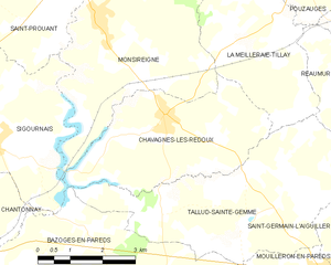
Chavagnes-les-Redoux
- commune in Vendée, France
- Country:
- Postal Code: 85390
- Coordinates: 46° 43' 0" N, 0° 55' 7" E
- GPS tracks (wikiloc): [Link]
- Area: 13.34 sq km
- Population: 832
- Web site: [Link]


Saint-Germain-de-Prinçay
- commune in Vendée, France
- Country:
- Postal Code: 85110
- Coordinates: 46° 43' 15" N, 1° 1' 18" E
- GPS tracks (wikiloc): [Link]
- Area: 24.34 sq km
- Population: 1515


Monsireigne
- commune in Vendée, France
- Country:
- Postal Code: 85110
- Coordinates: 46° 44' 42" N, 0° 56' 53" E
- GPS tracks (wikiloc): [Link]
- Area: 20.5 sq km
- Population: 972

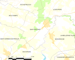
Saint-Prouant
- commune in Vendée, France
- Country:
- Postal Code: 85110
- Coordinates: 46° 45' 30" N, 0° 57' 25" E
- GPS tracks (wikiloc): [Link]
- Area: 12.86 sq km
- Population: 1552
- Web site: [Link]