Sireuil (Sireuil)

- commune in Charente, France
- Country:

- Postal Code: 16440
- Coordinates: 45° 36' 56" N, 0° 0' 35" E


- GPS tracks (wikiloc): [Link]
- Area: 10.01 sq km
- Population: 1155
- Wikipedia en: wiki(en)
- Wikipedia: wiki(fr)
- Wikidata storage: Wikidata: Q431815
- Wikipedia Commons Category: [Link]
- Freebase ID: [/m/03mcdx3]
- GeoNames ID: Alt: [6427869]
- SIREN number: [211603709]
- BnF ID: [15248807k]
- VIAF ID: Alt: [141741110]
- Library of Congress authority ID: Alt: [n87803607]
- Digital Atlas of the Roman Empire ID: [10193]
- INSEE municipality code: 16370
Shares border with regions:


Roullet-Saint-Estèphe
- commune in Charente, France
- Country:
- Postal Code: 16440
- Coordinates: 45° 35' 1" N, 0° 2' 50" E
- GPS tracks (wikiloc): [Link]
- AboveSeaLevel: 26 м m
- Area: 41.5 sq km
- Population: 4251
- Web site: [Link]

Nersac
- commune in Charente, France
- Country:
- Postal Code: 16440
- Coordinates: 45° 37' 33" N, 0° 3' 3" E
- GPS tracks (wikiloc): [Link]
- Area: 9.24 sq km
- Population: 2398
- Web site: [Link]

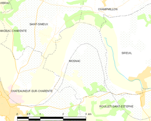
Mosnac
- commune in Charente, France
- Country:
- Postal Code: 16120
- Coordinates: 45° 37' 7" N, 0° 1' 8" E
- GPS tracks (wikiloc): [Link]
- Area: 6.33 sq km
- Population: 464


Champmillon
- commune in Charente, France
- Country:
- Postal Code: 16290
- Coordinates: 45° 38' 21" N, 0° 0' 1" E
- GPS tracks (wikiloc): [Link]
- AboveSeaLevel: 96 м m
- Area: 9.51 sq km
- Population: 520


Trois-Palis
- commune in Charente, France
- Country:
- Postal Code: 16730
- Coordinates: 45° 38' 24" N, 0° 3' 20" E
- GPS tracks (wikiloc): [Link]
- Area: 4.22 sq km
- Population: 939
- Web site: [Link]