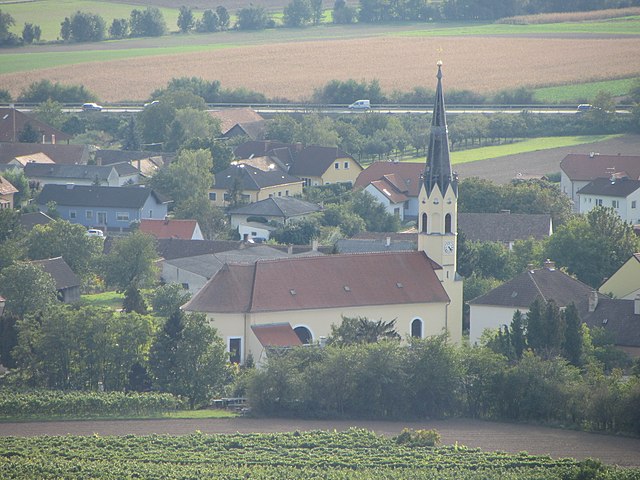
Stetteldorf am Wagram (Stetteldorf am Wagram)
- municipality in Austria
 Hiking in Stetteldorf am Wagram
Stetteldorf am Wagram is a charming village located in the Lower Austria region, near the Danube River and surrounded by scenic landscapes. Hiking in this area offers a mix of beautiful nature, vineyards, and cultural sites. Here are some highlights and tips for hiking in and around Stetteldorf am Wagram:
Trails and Routes
-
Danube River Trails: The nearby Danube path (Donauradweg) is a popular hiking and biking route that provides stunning views of the river and the surrounding landscape. This flat, well-marked trail is suitable for all skill levels.
-
Wagram Wine Trail: The region is known for its vineyards, and hiking through these areas can be a delightful experience. Look for local wine trails that allow you to explore the vineyards and potentially enjoy some wine tasting along the way.
-
Forested Areas and Hills: There are various routes that take you into the nearby forested areas or up onto the Wagram Hills. These trails offer more challenging hikes with beautiful panoramas.
Nature and Scenery
-
The area around Stetteldorf is rich in biodiversity, with opportunities to see local flora and fauna. The seasons significantly change the landscape, with vibrant colors in autumn and lush greenery in spring and summer.
-
Lookout points along certain trails offer stunning views of the Wagram region and the Danube River, making for great photo opportunities.
Cultural Sites
-
While hiking, you might encounter historic sites such as local churches, traditional Austrian architecture, and possibly some small museums highlighting local history and culture.
-
Consider incorporating visits to local wineries or farms to experience the regional culture better.
Tips for Hikers
-
Dress Appropriately: Weather can change quickly, so wear layers and bring waterproof gear if necessary.
-
Stay Hydrated: Carry enough water, especially on warmer days, as some trails may not have water sources readily available.
-
Maps and Navigation: Utilize local maps or hiking apps to help navigate the trails, as some paths might not be well-marked.
-
Respect the Environment: Follow local guidelines for hiking, including sticking to marked trails and respecting wildlife.
Stetteldorf am Wagram offers a great mix of natural beauty, cultural experiences, and relaxation, making it a perfect destination for hikers of all levels. Enjoy your hike!
- Country:

- Postal Code: 3463
- Local Dialing Code: 02278
- Licence Plate Code: KO
- Coordinates: 48° 24' 31" N, 16° 0' 59" E


- GPS tracks (wikiloc): [Link]
- AboveSeaLevel: 213 м m
- Area: 25.74 sq km
- Population: 1041
- Web site: http://www.stetteldorf-wagram.gv.at
- Wikipedia en: wiki(en)
- Wikipedia: wiki(de)
- Wikidata storage: Wikidata: Q666571
- Wikipedia Commons Category: [Link]
- Freebase ID: [/m/02qxbdr]
- GeoNames ID: Alt: [2764368]
- VIAF ID: Alt: [244759971]
- Austrian municipality key: [31228]
Shares border with regions:

Absdorf
- municipality in Austria
Hiking in Absdorf
Absdorf is a small town located in Lower Austria, near the larger city of Tulln, making it a great spot for scenic hikes in the region. While it may not be as widely known as some larger hiking destinations, it offers access to beautiful landscapes, rolling hills, and local nature trails....
- Country:
- Postal Code: 3462
- Local Dialing Code: 02278
- Licence Plate Code: TU
- Coordinates: 48° 24' 1" N, 15° 58' 48" E
- GPS tracks (wikiloc): [Link]
- AboveSeaLevel: 182 м m
- Area: 16 sq km
- Population: 2087
- Web site: [Link]


Tulln an der Donau
- municipality in Austria
Hiking in Tulln an der Donau
Tulln an der Donau, located in Lower Austria near the Danube River, offers a variety of scenic hiking opportunities that showcase the region's natural beauty and rich cultural heritage. Here are some highlights for hiking in and around Tulln:...
- Country:
- Postal Code: 3425, 3430
- Local Dialing Code: 02272
- Licence Plate Code: TU
- Coordinates: 48° 20' 0" N, 16° 3' 0" E
- GPS tracks (wikiloc): [Link]
- AboveSeaLevel: 180 м m
- Area: 72.23 sq km
- Population: 16197
- Web site: [Link]


Großweikersdorf
- municipality in Austria
Hiking in Großweikersdorf
Großweikersdorf, located in the Lower Austria region, offers some beautiful hiking opportunities. The area features scenic landscapes, charming vineyards, and rolling hills, making it a great destination for outdoor enthusiasts....
- Country:
- Postal Code: 3701
- Local Dialing Code: 02955
- Licence Plate Code: TU
- Coordinates: 48° 28' 21" N, 15° 58' 48" E
- GPS tracks (wikiloc): [Link]
- AboveSeaLevel: 211 м m
- Area: 43.32 sq km
- Population: 3180
- Web site: [Link]


Königsbrunn am Wagram
- municipality in Austria
Hiking in Königsbrunn am Wagram
Königsbrunn am Wagram is a charming village located in the Lower Austria region, near the Wagram plateau, which is known for its scenic vineyards, rolling hills, and picturesque landscapes. Hiking in this area can provide a peaceful and enjoyable experience, surrounded by nature and beautiful views....
- Country:
- Postal Code: 3465
- Local Dialing Code: 02278
- Licence Plate Code: TU
- Coordinates: 48° 25' 0" N, 15° 56' 0" E
- GPS tracks (wikiloc): [Link]
- AboveSeaLevel: 197 м m
- Area: 28.57 sq km
- Population: 1319
- Web site: [Link]
Rußbach
- municipality in Austria
Hiking in Rußbach
Rußbach is a beautiful village located in the Salzburger Land region of Austria, known for its stunning natural scenery and excellent hiking opportunities. Nestled in the Dachstein Mountains, Rußbach offers a variety of hiking trails suitable for all experience levels, from leisurely walks to challenging mountain hikes....
- Country:
- Postal Code: 3702
- Local Dialing Code: 02955
- Licence Plate Code: KO
- Coordinates: 48° 27' 5" N, 16° 2' 22" E
- GPS tracks (wikiloc): [Link]
- AboveSeaLevel: 247 м m
- Area: 30.65 sq km
- Population: 1424
- Web site: [Link]

Hausleiten
- municipality in Austria
Hiking in Hausleiten
Hausleiten, located in Lower Austria, offers a variety of hiking opportunities set against picturesque landscapes. While the region is known for its rolling hills and scenic views, here are some general tips and highlights for hiking in Hausleiten:...
- Country:
- Postal Code: 3464
- Local Dialing Code: 02265
- Licence Plate Code: KO
- Coordinates: 48° 23' 41" N, 16° 6' 15" E
- GPS tracks (wikiloc): [Link]
- AboveSeaLevel: 207 м m
- Area: 61.03 sq km
- Population: 3784
- Web site: [Link]