Tassin-la-Demi-Lune (Tassin-la-Demi-Lune)

- commune in the metropolis of Lyon, France
- Country:

- Postal Code: 69160
- Coordinates: 45° 45' 48" N, 4° 46' 48" E


- GPS tracks (wikiloc): [Link]
- AboveSeaLevel: 225 м m
- Area: 7.79 sq km
- Population: 21793
- Web site: http://www.tassinlademilune.fr/
- Wikipedia en: wiki(en)
- Wikipedia: wiki(fr)
- Wikidata storage: Wikidata: Q1647506
- Wikipedia Commons Category: [Link]
- Wikipedia Commons Maps Category: [Link]
- Freebase ID: [/m/03qlldx]
- Freebase ID: [/m/03qlldx]
- Freebase ID: [/m/03qlldx]
- GeoNames ID: Alt: [2973317]
- GeoNames ID: Alt: [2973317]
- GeoNames ID: Alt: [2973317]
- SIREN number: [216902445]
- SIREN number: [216902445]
- SIREN number: [216902445]
- BnF ID: [15272330w]
- BnF ID: [15272330w]
- BnF ID: [15272330w]
- VIAF ID: Alt: [312818051]
- VIAF ID: Alt: [312818051]
- VIAF ID: Alt: [312818051]
- GND ID: Alt: [4542234-5]
- GND ID: Alt: [4542234-5]
- GND ID: Alt: [4542234-5]
- Library of Congress authority ID: Alt: [n85094833]
- Library of Congress authority ID: Alt: [n85094833]
- Library of Congress authority ID: Alt: [n85094833]
- MusicBrainz area ID: [a52a7f54-ab2f-46ef-b164-7c7be3ef72b1]
- MusicBrainz area ID: [a52a7f54-ab2f-46ef-b164-7c7be3ef72b1]
- MusicBrainz area ID: [a52a7f54-ab2f-46ef-b164-7c7be3ef72b1]
- SUDOC authorities ID: [032215312]
- SUDOC authorities ID: [032215312]
- SUDOC authorities ID: [032215312]
- INSEE municipality code: 69244
- INSEE municipality code: 69244
- INSEE municipality code: 69244
Shares border with regions:

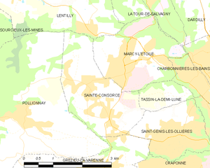
Sainte-Consorce
- commune in Rhône, France
- Country:
- Postal Code: 69280
- Coordinates: 45° 46' 33" N, 4° 41' 25" E
- GPS tracks (wikiloc): [Link]
- Area: 5.81 sq km
- Population: 1909
- Web site: [Link]


Marcy-l'Étoile
- commune in the metropolis of Lyon, France
- Country:
- Postal Code: 69280
- Coordinates: 45° 46' 52" N, 4° 42' 22" E
- GPS tracks (wikiloc): [Link]
- Area: 5.37 sq km
- Population: 3789
- Web site: [Link]

Écully
- commune in the metropolis of Lyon, France
- Country:
- Postal Code: 69130
- Coordinates: 45° 46' 28" N, 4° 46' 39" E
- GPS tracks (wikiloc): [Link]
- Area: 8.45 sq km
- Population: 17947
- Web site: [Link]


Francheville, Rhône
- commune in the metropolis of Lyon, France
- Country:
- Postal Code: 69340
- Coordinates: 45° 44' 11" N, 4° 45' 49" E
- GPS tracks (wikiloc): [Link]
- Area: 8.18 sq km
- Population: 14361
- Web site: [Link]
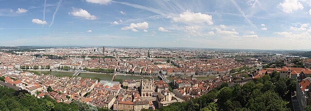
Lyon
- commune in the metropolis of Lyon, France
- Country:
- Postal Code: 69009; 69008; 69007; 69006; 69005; 69004; 69003; 69002; 69001
- Licence Plate Code: 69
- Coordinates: 45° 45' 32" N, 4° 50' 29" E
- GPS tracks (wikiloc): [Link]
- AboveSeaLevel: 173 м m
- Area: 47.87 sq km
- Population: 506615
- Web site: [Link]


Saint-Genis-les-Ollières
- commune in the metropolis of Lyon, France
- Country:
- Postal Code: 69290
- Coordinates: 45° 45' 26" N, 4° 43' 35" E
- GPS tracks (wikiloc): [Link]
- Area: 3.74 sq km
- Population: 4774
- Web site: [Link]


Charbonnières-les-Bains
- commune in the metropolis of Lyon, France
- Country:
- Postal Code: 69260
- Coordinates: 45° 46' 50" N, 4° 44' 47" E
- GPS tracks (wikiloc): [Link]
- Area: 4.13 sq km
- Population: 5003
- Web site: [Link]


Craponne
- commune in the metropolis of Lyon, France
- Country:
- Postal Code: 69290
- Coordinates: 45° 44' 43" N, 4° 43' 24" E
- GPS tracks (wikiloc): [Link]
- Area: 4.62 sq km
- Population: 10979
- Web site: [Link]