Vendières (Vendières)

- commune in Aisne, France
- Country:

- Postal Code: 02540
- Coordinates: 48° 52' 15" N, 3° 26' 49" E


- GPS tracks (wikiloc): [Link]
- Area: 12.35 sq km
- Population: 166
- Wikipedia en: wiki(en)
- Wikipedia: wiki(fr)
- Wikidata storage: Wikidata: Q868201
- Wikipedia Commons Category: [Link]
- Freebase ID: [/m/03m7r62]
- Freebase ID: [/m/03m7r62]
- GeoNames ID: Alt: [6615220]
- GeoNames ID: Alt: [6615220]
- SIREN number: [210207502]
- SIREN number: [210207502]
- INSEE municipality code: 02777
- INSEE municipality code: 02777
Shares border with regions:


Montdauphin
- commune in Seine-et-Marne, France
- Country:
- Postal Code: 77320
- Coordinates: 48° 51' 5" N, 3° 25' 42" E
- GPS tracks (wikiloc): [Link]
- Area: 9.84 sq km
- Population: 243

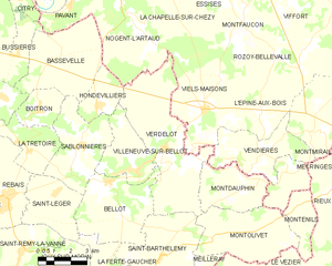
Verdelot
- commune in Seine-et-Marne, France
- Country:
- Postal Code: 77510
- Coordinates: 48° 52' 30" N, 3° 21' 57" E
- GPS tracks (wikiloc): [Link]
- Area: 25.6 sq km
- Population: 692


Mécringes
- commune in Marne, France
- Country:
- Postal Code: 51210
- Coordinates: 48° 51' 50" N, 3° 31' 26" E
- GPS tracks (wikiloc): [Link]
- Area: 10.68 sq km
- Population: 193

La Celle-sous-Montmirail
- former commune in Aisne, France
- Country:
- Postal Code: 02540
- Coordinates: 48° 51' 53" N, 3° 27' 58" E
- GPS tracks (wikiloc): [Link]
- AboveSeaLevel: 120 м m
- Area: 5.67 sq km
- Population: 117

Viels-Maisons
- commune in Aisne, France
- Country:
- Postal Code: 02540
- Coordinates: 48° 53' 48" N, 3° 23' 50" E
- GPS tracks (wikiloc): [Link]
- Area: 21.44 sq km
- Population: 1179

L'Épine-aux-Bois
- commune in Aisne, France
- Country:
- Postal Code: 02540
- Coordinates: 48° 53' 8" N, 3° 26' 56" E
- GPS tracks (wikiloc): [Link]
- Area: 12.37 sq km
- Population: 265

Marchais-en-Brie
- former commune in Aisne, France
- Country:
- Postal Code: 02540
- Coordinates: 48° 53' 2" N, 3° 29' 2" E
- GPS tracks (wikiloc): [Link]
- Area: 12.78 sq km
- Population: 328