Vitry-en-Artois (Vitry-en-Artois)

- commune in Pas-de-Calais, France
- Country:

- Postal Code: 62490
- Coordinates: 50° 19' 33" N, 2° 58' 59" E


- GPS tracks (wikiloc): [Link]
- Area: 18.78 sq km
- Population: 4631
- Web site: http://www.vitryenartois.fr
- Wikipedia en: wiki(en)
- Wikipedia: wiki(fr)
- Wikidata storage: Wikidata: Q323593
- Wikipedia Commons Category: [Link]
- Freebase ID: [/m/0283cc]
- GeoNames ID: Alt: [6439954]
- SIREN number: [216208652]
- BnF ID: [15269306h]
- VIAF ID: Alt: [153737229]
- Library of Congress authority ID: Alt: [n90681368]
- PACTOLS thesaurus ID: [pcrtmsISnJTvhX]
- WOEID: [632485]
- INSEE municipality code: 62865
Shares border with regions:

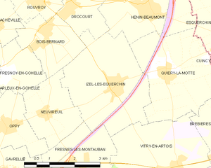
Izel-lès-Équerchin
- commune in Pas-de-Calais, France
- Country:
- Postal Code: 62490
- Coordinates: 50° 21' 42" N, 2° 57' 0" E
- GPS tracks (wikiloc): [Link]
- Area: 9.91 sq km
- Population: 960


Noyelles-sous-Bellonne
- commune in Pas-de-Calais, France
- Country:
- Postal Code: 62490
- Coordinates: 50° 18' 29" N, 3° 1' 38" E
- GPS tracks (wikiloc): [Link]
- Area: 4.21 sq km
- Population: 819
- Web site: [Link]


Fresnes-lès-Montauban
- commune in Pas-de-Calais, France
- Country:
- Postal Code: 62490
- Coordinates: 50° 19' 59" N, 2° 55' 52" E
- GPS tracks (wikiloc): [Link]
- Area: 4.95 sq km
- Population: 569
- Web site: [Link]


Quiéry-la-Motte
- commune in Pas-de-Calais, France
- Country:
- Postal Code: 62490
- Coordinates: 50° 21' 57" N, 2° 58' 41" E
- GPS tracks (wikiloc): [Link]
- Area: 8.93 sq km
- Population: 732
- Web site: [Link]

Biache-Saint-Vaast
- commune in Pas-de-Calais, France
- Country:
- Postal Code: 62118
- Coordinates: 50° 18' 42" N, 2° 56' 39" E
- GPS tracks (wikiloc): [Link]
- Area: 9.29 sq km
- Population: 4010
- Web site: [Link]


Brebières
- commune in Pas-de-Calais, France
- Country:
- Postal Code: 62117
- Coordinates: 50° 20' 13" N, 3° 1' 22" E
- GPS tracks (wikiloc): [Link]
- Area: 10.8 sq km
- Population: 4904
- Web site: [Link]

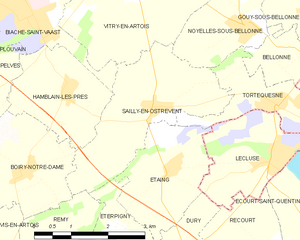
Sailly-en-Ostrevent
- commune in Pas-de-Calais, France
- Country:
- Postal Code: 62490
- Coordinates: 50° 17' 20" N, 2° 59' 38" E
- GPS tracks (wikiloc): [Link]
- Area: 7.43 sq km
- Population: 720