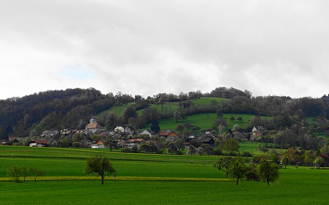
Vovray-en-Bornes (Vovray-en-Bornes)

- commune in Haute-Savoie, France
 Hiking in Vovray-en-Bornes
Vovray-en-Bornes is a picturesque village located in the Haute-Savoie region of France, which offers a variety of hiking opportunities for outdoor enthusiasts. The area is characterized by stunning natural beauty, including forests, rolling hills, and views of the nearby mountains.
Hiking Opportunities:
-
Trail Varieties: The region around Vovray-en-Bornes has various trails suitable for different skill levels, from easy walks suitable for families to more challenging hikes for experienced trekkers.
-
Scenic Views: Many trails provide breathtaking views of the surrounding Alps and the Rhône Valley. You can expect to encounter beautiful landscapes, including alpine meadows, dense forests, and possibly even local wildlife.
-
Local Flora and Fauna: While hiking, you may see a variety of plant and animal species native to the region. Be on the lookout for local wildflowers in the spring and summer months, as well as various birds and other wildlife.
-
Connecting Trails: Vovray-en-Bornes is well connected to larger hiking routes in the region, allowing for longer multi-day hikes if you wish to explore further afield.
Tips for Hiking in Vovray-en-Bornes:
-
Preparation: Always check the local weather conditions before heading out and prepare accordingly. Weather in the mountains can change rapidly.
-
Appropriate Gear: Wear comfortable, weather-appropriate clothing and sturdy hiking boots. It’s advisable to bring a map, compass or GPS device, plenty of water, and snacks.
-
Respect Nature: Follow Leave No Trace principles to preserve the beauty of the area for future hikers. Stay on marked trails to minimize the impact on the environment.
-
Local Guides: Consider hiring a local hiking guide, especially if you’re unfamiliar with the terrain. They can provide valuable insights into the area’s natural history and hidden gems.
Vovray-en-Bornes can be an excellent base for exploring the beautiful hiking routes of the Haute-Savoie region, combining leisure and outdoor adventure in a stunning alpine setting. Enjoy your hike and take in the beauty of the French Alps!
- Country:

- Postal Code: 74350
- Coordinates: 46° 3' 56" N, 6° 8' 33" E


- GPS tracks (wikiloc): [Link]
- Area: 6.57 sq km
- Population: 441
- Web site: http://www.vovray-en-bornes.fr
- Wikipedia en: wiki(en)
- Wikipedia: wiki(fr)
- Wikidata storage: Wikidata: Q845395
- Wikipedia Commons Category: [Link]
- Freebase ID: [/m/03ntxp9]
- GeoNames ID: Alt: [6443084]
- SIREN number: [217403138]
- BnF ID: [15274565k]
- INSEE municipality code: 74313
Shares border with regions:


Cruseilles
- commune in Haute-Savoie, France
Hiking in Cruseilles
Cruseilles, located in the Auvergne-Rhône-Alpes region of France, offers scenic hiking opportunities with stunning views of the surrounding countryside and the nearby mountains, including the Saleve and the Bornes mountains. Here are some key points about hiking in Cruseilles:...
- Country:
- Postal Code: 74350
- Coordinates: 46° 2' 3" N, 6° 6' 27" E
- GPS tracks (wikiloc): [Link]
- Area: 25.41 sq km
- Population: 4326
- Web site: [Link]


Menthonnex-en-Bornes
- commune in Haute-Savoie, France
Hiking in Menthonnex-en-Bornes
Menthonnex-en-Bornes is a picturesque village located in the Auvergne-Rhône-Alpes region of France, near the French Alps. It offers a variety of hiking opportunities for both novice and experienced hikers, thanks to its beautiful landscapes, rolling hills, and proximity to the mountains....
- Country:
- Postal Code: 74350
- Coordinates: 46° 3' 10" N, 6° 10' 24" E
- GPS tracks (wikiloc): [Link]
- Area: 8.48 sq km
- Population: 1074
- Web site: [Link]


Le Sappey
- commune in Haute-Savoie, France
Hiking in Le Sappey
Le Sappey-en-Chartreuse is a charming village located in the Chartreuse Mountains, near Grenoble in the French Alps. It's a fantastic base for hiking enthusiasts, offering a variety of trails suitable for all levels of experience. Here’s what you can expect when hiking in Le Sappey:...
- Country:
- Postal Code: 74350
- Coordinates: 46° 5' 19" N, 6° 9' 57" E
- GPS tracks (wikiloc): [Link]
- Area: 13.72 sq km
- Population: 407
- Web site: [Link]

Présilly
- commune in Haute-Savoie, France
Hiking in Présilly
Présilly, located in the Haute-Savoie region of France, offers a variety of hiking opportunities amidst stunning Alpine scenery. This picturesque village is well-positioned near the French-Swiss border, providing access to beautiful trails and natural landscapes....
- Country:
- Postal Code: 74160
- Coordinates: 46° 5' 35" N, 6° 4' 40" E
- GPS tracks (wikiloc): [Link]
- Area: 8.66 sq km
- Population: 774


Villy-le-Bouveret
- commune in Haute-Savoie, France
Hiking in Villy-le-Bouveret
Villy-le-Bouveret, located in the region of Vaud in Switzerland, offers some beautiful hiking opportunities, especially given its proximity to the stunning landscapes of the Swiss Alps and Lake Geneva. The area is characterized by lush greenery, rolling hills, and scenic views, making it an ideal spot for hiking enthusiasts....
- Country:
- Postal Code: 74350
- Coordinates: 46° 2' 38" N, 6° 9' 44" E
- GPS tracks (wikiloc): [Link]
- Area: 3.49 sq km
- Population: 604
- Web site: [Link]