Wargnies (Wargnies)

- commune in Somme, France
- Country:

- Postal Code: 80670
- Coordinates: 50° 2' 5" N, 2° 15' 21" E


- GPS tracks (wikiloc): [Link]
- Area: 2.82 sq km
- Population: 90
- Wikipedia en: wiki(en)
- Wikipedia: wiki(fr)
- Wikidata storage: Wikidata: Q839747
- Wikipedia Commons Category: [Link]
- Freebase ID: [/m/03qmrtq]
- GeoNames ID: Alt: [6444814]
- SIREN number: [218007672]
- BnF ID: [15277290p]
- INSEE municipality code: 80819
Shares border with regions:


Flesselles
- commune in Somme, France
- Country:
- Postal Code: 80260
- Coordinates: 50° 0' 5" N, 2° 15' 36" E
- GPS tracks (wikiloc): [Link]
- Area: 20.49 sq km
- Population: 2102

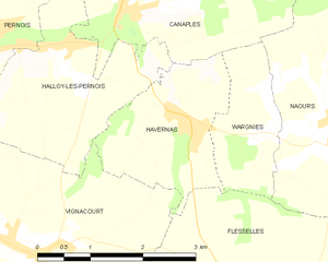
Havernas
- commune in Somme, France
- Country:
- Postal Code: 80670
- Coordinates: 50° 2' 11" N, 2° 14' 9" E
- GPS tracks (wikiloc): [Link]
- Area: 4.48 sq km
- Population: 403


Naours
- commune in Somme, France
- Country:
- Postal Code: 80260
- Coordinates: 50° 2' 7" N, 2° 16' 35" E
- GPS tracks (wikiloc): [Link]
- Area: 16.55 sq km
- Population: 1069

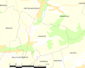
Canaples
- commune in Somme, France
- Country:
- Postal Code: 80670
- Coordinates: 50° 3' 23" N, 2° 13' 4" E
- GPS tracks (wikiloc): [Link]
- Area: 10.26 sq km
- Population: 687
- Web site: [Link]