Айроле (Airole, Airole)
.svg)
- коммуна Италии
 Hiking in Айроле
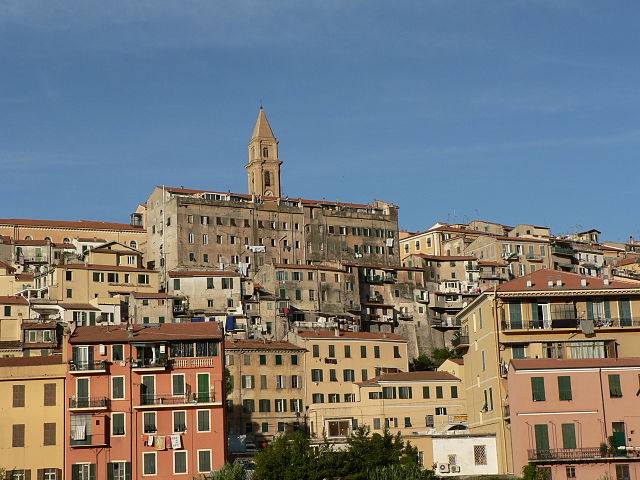
Airole is a charming village located in the Liguria region of Italy, near the border with France. It’s nestled in the picturesque valley of the Nervia River, surrounded by stunning landscapes that make it an attractive destination for hikers and nature enthusiasts. Here are some key points to consider when hiking in and around Airole:
Hiking Trails
-
Valle del Nervia: The valley itself offers a variety of trails that cater to different skill levels. You can find easy walks along the river as well as more challenging routes that lead up into the hills.
-
Monte Saccarello: This is the highest peak in the area and offers breathtaking views of both the Ligurian coastline and the French Alps. The hike to Monte Saccarello can be demanding but rewarding.
-
Old Paths (Mulattiere): There are numerous ancient paths in and around Airole that were once used for trade and local transport. These trails often feature beautiful stone bridges and views of the surrounding landscape.
Difficulty Levels
The hiking trails in the Airole area vary in difficulty, from easy walks perfect for families to more challenging hikes suitable for experienced hikers. It’s advisable to check trail signs and ensure you have a good map or a GPS device.
Best Time to Hike
The best times to hike in Airole are spring (April to June) and autumn (September to October), as temperatures are mild and the scenery is vibrant. Summers can be hot, while winters may bring snow, particularly at higher elevations.
Essential Tips
- Equipment: Wear sturdy hiking boots, and bring a backpack with water, snacks, a map, sunscreen, and a first-aid kit.
- Wildlife: Be aware of the local wildlife, including various birds and possibly deer. Observe from a distance to avoid startling them.
- Respect Nature: Stay on marked trails, take trash with you, and consider the local environment and community.
Local Attractions
- Airole Village: Take some time to explore the village itself, which has a rich history and beautiful architecture, as well as local dining options to enjoy traditional Ligurian cuisine.
- Nearby Towns: Consider taking short trips to nearby towns such as Dolceacqua or Apricale, both of which offer their own hiking opportunities and scenic views.
Hiking in Airole offers a beautiful blend of nature, history, and culture, making it a great destination for both casual walkers and seasoned hikers. Always check local resources for trail conditions and maps before setting out!
- Страна:

- Почтовый код: 18030
- Телефонный код: 0184
- Код автомобильного номера: IM
- Координаты: 43° 52' 19" N, 7° 33' 12" E


- GPS треки (wikiloc): [Ссылка]
- Высота над уровнем моря: 149 м m
- Площадь: 14.63 кв.км
- Население: 408
- Веб сайт: http://www.comune.airole.im.it/
- Википедия русская: wiki(ru)
- Википедия английская: wiki(en)
- Википедия национальная: wiki(it)
- Хранилище Wikidata: Wikidata: Q264583
- Катеория в википедии: [Ссылка]
- код Freebase: [/m/0gbr3c]
- код GeoNames: Альт: [6536063]
- ID отношения в OpenStreetMap: [42712]
- код ISTAT: 008001
- кадастровый код Италии: A111
Граничит с регионами:

Вентимилья
- коммуна Италии
Hiking in Вентимилья
Ventimiglia, located in the Italian Riviera near the border with France, is a fantastic destination for hiking enthusiasts. The area is blessed with stunning coastal views, lush Mediterranean vegetation, and a variety of trails suitable for different skill levels. Here are some highlights and tips for hiking in Ventimiglia:...
- Страна:
- Почтовый код: 18039
- Телефонный код: 0184
- Код автомобильного номера: IM
- Координаты: 43° 47' 25" N, 7° 36' 30" E
- GPS треки (wikiloc): [Ссылка]
- Высота над уровнем моря: 9 м m
- Площадь: 53.73 кв.км
- Население: 24065
- Веб сайт: [Ссылка]


Дольчеаккуа
- коммуна Италии
Hiking in Дольчеаккуа
Dolceacqua is a charming village located in the Italian region of Liguria, near the border with France. It’s known for its picturesque medieval architecture, stunning landscapes, and the beautiful surrounding hills and valleys that offer a variety of hiking opportunities....
- Страна:
- Почтовый код: 18035
- Телефонный код: 0184
- Код автомобильного номера: IM
- Координаты: 43° 50' 53" N, 7° 37' 26" E
- GPS треки (wikiloc): [Ссылка]
- Высота над уровнем моря: 51 м m
- Площадь: 20.28 кв.км
- Население: 2093
- Веб сайт: [Ссылка]


Оливетта-Сан-Микеле
- коммуна Италии
Hiking in Оливетта-Сан-Микеле
Olivetta San Michele is a charming village located in the province of Imperia, in the Liguria region of Italy. Nestled in the beautiful Alps of Liguria, it offers stunning landscapes, rich natural beauty, and several hiking opportunities for outdoor enthusiasts....
- Страна:
- Почтовый код: 18030
- Телефонный код: 0184
- Код автомобильного номера: IM
- Координаты: 43° 52' 47" N, 7° 30' 56" E
- GPS треки (wikiloc): [Ссылка]
- Высота над уровнем моря: 292 м m
- Площадь: 13.84 кв.км
- Население: 214
- Веб сайт: [Ссылка]


Брей-сюр-Руайя
- коммуна в департаменте Приморские Альпы, регион Прованс — Альпы — Лазурный Берег, Франция
Hiking in Брей-сюр-Руайя
Breil-sur-Roya, located in the Alpes-Maritimes department of France, is a charming village that serves as a gateway to some beautiful hiking trails in the surrounding area. Nestled in the Roya Valley, it offers a mix of stunning natural landscapes, historical sites, and a chance to experience the local culture....
- Страна:

- Почтовый код: 06540
- Координаты: 43° 56' 14" N, 7° 30' 52" E
- GPS треки (wikiloc): [Ссылка]
- Высота над уровнем моря: 287 м m
- Площадь: 81.31 кв.км
- Население: 2271
- Веб сайт: [Ссылка]