Дольчеаккуа (Dolceacqua, Dolceacqua)
.svg)
- коммуна Италии
 Hiking in Дольчеаккуа
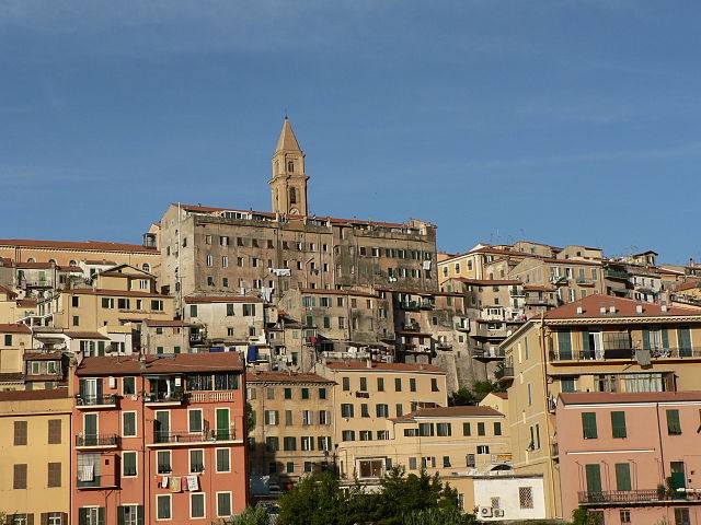
Dolceacqua is a charming village located in the Italian region of Liguria, near the border with France. It’s known for its picturesque medieval architecture, stunning landscapes, and the beautiful surrounding hills and valleys that offer a variety of hiking opportunities.
Hiking Trails in Dolceacqua
-
The Nervia Valley: This valley offers several hiking trails that lead through lush landscapes, vineyards, and olive groves. Trails vary in difficulty but provide breathtaking views of the river and surrounding hills.
-
The Medieval Path: A scenic walking trail that connects Dolceacqua to the nearby village of Apricale. This route takes you through history, as you can see ancient ruins and medieval architecture along the way.
-
Mount Gagliardone: For those seeking a more challenging hike, this mountain offers steep paths and rewarding panoramic views of Dolceacqua and the coast. Make sure to bring plenty of water and snacks, as the trek can be quite demanding.
-
Les Vignes: This is a gentler trail that takes you through local vineyards. It's a great way to experience the rural landscape and the region's winemaking tradition, and you might even find opportunities for wine tasting along the way.
Hiking Tips
- Preparation: Always check the weather conditions before setting out. The climate in Liguria can change rapidly, especially in the mountainous areas.
- Footwear: Good hiking boots are essential, as trails can be rocky and uneven. Make sure your footwear is broken in to avoid blisters.
- Map and Navigation: While many trails are marked, carrying a map or having a navigation app can be helpful, especially for less popular paths.
- Respect Nature: Stay on marked trails and follow local guidelines to preserve the natural environment and wildlife.
- Local Cuisine: Don’t miss the chance to enjoy local food and wine after your hike. The area is known for delicious Ligurian cuisine.
Conclusion
Hiking in Dolceacqua offers a unique combination of natural beauty and historical exploration. Whether you’re looking for a casual stroll or a more challenging mountain hike, the area’s trails are sure to provide a memorable experience. Enjoy your time in this beautiful region!
- Страна:

- Почтовый код: 18035
- Телефонный код: 0184
- Код автомобильного номера: IM
- Координаты: 43° 50' 53" N, 7° 37' 26" E


- GPS треки (wikiloc): [Ссылка]
- Высота над уровнем моря: 51 м m
- Площадь: 20.28 кв.км
- Население: 2093
- Веб сайт: http://www.dolceacqua.it
- Википедия русская: wiki(ru)
- Википедия английская: wiki(en)
- Википедия национальная: wiki(it)
- Хранилище Wikidata: Wikidata: Q268995
- Галерея изображений в википедии: [Ссылка]
- Катеория в википедии: [Ссылка]
- код Freebase: [/m/0gbyny]
- код GeoNames: Альт: [6536072]
- код VIAF: Альт: [247403261]
- ID отношения в OpenStreetMap: [42681]
- код темы Quora: [Dolceacqua]
- UN/LOCODE: [ITDCC]
- код ISTAT: 008029
- кадастровый код Италии: D318
Граничит с регионами:

Вентимилья
- коммуна Италии
Hiking in Вентимилья
Ventimiglia, located in the Italian Riviera near the border with France, is a fantastic destination for hiking enthusiasts. The area is blessed with stunning coastal views, lush Mediterranean vegetation, and a variety of trails suitable for different skill levels. Here are some highlights and tips for hiking in Ventimiglia:...
- Страна:
- Почтовый код: 18039
- Телефонный код: 0184
- Код автомобильного номера: IM
- Координаты: 43° 47' 25" N, 7° 36' 30" E
- GPS треки (wikiloc): [Ссылка]
- Высота над уровнем моря: 9 м m
- Площадь: 53.73 кв.км
- Население: 24065
- Веб сайт: [Ссылка]


Сан-Бьяджо-делла-Чима
- коммуна Италии
Hiking in Сан-Бьяджо-делла-Чима
San Biagio della Cima is a charming village located in the region of Liguria, Italy, and is part of the municipality of Ventimiglia. Nestled in the hills above the coastal region, it offers a variety of hiking opportunities that showcase the stunning natural beauty of the area....
- Страна:
- Почтовый код: 18036
- Телефонный код: 0184
- Код автомобильного номера: IM
- Координаты: 43° 49' 7" N, 7° 38' 59" E
- GPS треки (wikiloc): [Ссылка]
- Высота над уровнем моря: 100 м m
- Площадь: 4.31 кв.км
- Население: 1305
- Веб сайт: [Ссылка]


Айроле
- коммуна Италии
Hiking in Айроле
Airole is a charming village located in the Liguria region of Italy, near the border with France. It’s nestled in the picturesque valley of the Nervia River, surrounded by stunning landscapes that make it an attractive destination for hikers and nature enthusiasts. Here are some key points to consider when hiking in and around Airole:...
- Страна:
- Почтовый код: 18030
- Телефонный код: 0184
- Код автомобильного номера: IM
- Координаты: 43° 52' 19" N, 7° 33' 12" E
- GPS треки (wikiloc): [Ссылка]
- Высота над уровнем моря: 149 м m
- Площадь: 14.63 кв.км
- Население: 408
- Веб сайт: [Ссылка]


Априкале
- коммуна Италии
Hiking in Априкале
Apricale, a picturesque village in the Liguria region of Italy, offers some fantastic hiking opportunities. Nestled in the Sanremo valleys and surrounded by lush vegetation, it boasts beautiful landscapes, historical sites, and a rich cultural experience....
- Страна:
- Почтовый код: 18035
- Телефонный код: 0184
- Код автомобильного номера: IM
- Координаты: 43° 52' 50" N, 7° 39' 38" E
- GPS треки (wikiloc): [Ссылка]
- Высота над уровнем моря: 291 м m
- Площадь: 19.94 кв.км
- Население: 618
- Веб сайт: [Ссылка]


Кампороссо
- коммуна Италии
Hiking in Кампороссо
Camporosso is a beautiful village located in the Italian region of Liguria, nestled in the heart of the Italian Riviera. This area is known for its stunning natural landscapes, offering a variety of hiking opportunities for outdoor enthusiasts. Here are some key points to consider if you're planning to hike in and around Camporosso:...
- Страна:
- Почтовый код: 18033
- Телефонный код: 0184
- Код автомобильного номера: IM
- Координаты: 43° 48' 54" N, 7° 37' 42" E
- GPS треки (wikiloc): [Ссылка]
- Высота над уровнем моря: 25 м m
- Площадь: 17.94 кв.км
- Население: 5559
- Веб сайт: [Ссылка]


Изолабона
- коммуна Италии
Hiking in Изолабона
Isolabona is a charming village located in the Province of Imperia in the Liguria region of northwestern Italy. It is nestled in the picturesque Nervia Valley, surrounded by lush hills and stunning landscapes, making it a hidden gem for hikers and outdoor enthusiasts....
- Страна:
- Почтовый код: 18035
- Телефонный код: 0184
- Код автомобильного номера: IM
- Координаты: 43° 52' 46" N, 7° 38' 20" E
- GPS треки (wikiloc): [Ссылка]
- Высота над уровнем моря: 106 м m
- Площадь: 12.35 кв.км
- Население: 695
- Веб сайт: [Ссылка]


Перинальдо
- коммуна Италии
Hiking in Перинальдо
Perinaldo is a charming village located in the Italian region of Liguria, known for its stunning natural landscapes and historic architecture. It's situated in the hills above the Riviera dei Fiori, offering excellent opportunities for hiking and outdoor activities. Here are some key points about hiking in Perinaldo:...
- Страна:
- Почтовый код: 18032
- Телефонный код: 0184
- Код автомобильного номера: IM
- Координаты: 43° 52' 1" N, 7° 40' 28" E
- GPS треки (wikiloc): [Ссылка]
- Высота над уровнем моря: 572 м m
- Площадь: 20.3 кв.км
- Население: 871
- Веб сайт: [Ссылка]


Роккетта-Нервина
- коммуна Италии
Hiking in Роккетта-Нервина
Rocchetta Nervina is a charming village located in the Liguria region of Italy, specifically in the Province of Imperia. Nestled in the Nervia Valley and surrounded by stunning mountainous terrain, it serves as an excellent base for hiking enthusiasts looking to explore the natural beauty of the area....
- Страна:
- Почтовый код: 18030
- Телефонный код: 0184
- Код автомобильного номера: IM
- Координаты: 43° 53' 24" N, 7° 36' 1" E
- GPS треки (wikiloc): [Ссылка]
- Высота над уровнем моря: 235 м m
- Площадь: 15.29 кв.км
- Население: 299
- Веб сайт: [Ссылка]


Брей-сюр-Руайя
- коммуна в департаменте Приморские Альпы, регион Прованс — Альпы — Лазурный Берег, Франция
Hiking in Брей-сюр-Руайя
Breil-sur-Roya, located in the Alpes-Maritimes department of France, is a charming village that serves as a gateway to some beautiful hiking trails in the surrounding area. Nestled in the Roya Valley, it offers a mix of stunning natural landscapes, historical sites, and a chance to experience the local culture....
- Страна:

- Почтовый код: 06540
- Координаты: 43° 56' 14" N, 7° 30' 52" E
- GPS треки (wikiloc): [Ссылка]
- Высота над уровнем моря: 287 м m
- Площадь: 81.31 кв.км
- Население: 2271
- Веб сайт: [Ссылка]