
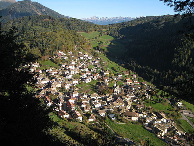
Альдино (Aldein, Aldino)
.svg)
- коммуна Италии
 Hiking in Альдино
Aldein, located in the South Tyrol region of Northern Italy, is a wonderful destination for hiking enthusiasts. Nestled in the scenic mountains, it offers a variety of trails that cater to different skill levels, from leisurely walks to more challenging treks. Here are some highlights about hiking in Aldein:
Scenic Trails:
-
Rittner Horn: This area features numerous trails with breathtaking views of the surrounding mountains and valleys. The hike to Rittner Horn is particularly popular and offers panoramic vistas.
-
Lago di Aldein: A serene lake perfect for a peaceful hike. The trails around the lake are great for families and offer a chance to enjoy nature at a leisurely pace.
-
Cascate di Trodena: This trail leads to scenic waterfalls, making it a wonderful choice for those who enjoy natural beauty. The sound of cascading water adds to the experience.
-
Mendel Pass: A bit further out but accessible from Aldein, Mendel Pass offers spectacular hiking paths with views of both the Val di Non and the southern part of South Tyrol.
Flora and Fauna:
The region around Aldein is rich in biodiversity. Hikers can expect to see various plant species, alpine flowers, and possibly spot local wildlife like deer and numerous bird species.
Hiking Tips:
- Season: The best time for hiking in this area is typically from late spring to early autumn, when the weather is mild and trails are well-maintained.
- Gear: Wear appropriate hiking shoes and consider layering your clothing, as temperatures can change significantly in the mountains.
- Trail Maps: Always carry a map or GPS device, and if you are unsure about any trail, consider joining a guided hike for the best experience.
Local Culture:
While hiking, you might also have the opportunity to explore local traditions and cuisine in Aldein. Try local dishes such as speck and apple strudel, and enjoy the hospitality of the mountain huts.
Accessibility:
Aldein is quite accessible from major towns in South Tyrol, and several hiking routes can also be reached using public transportation.
Whether you're a seasoned hiker or just looking for a peaceful walking experience, Aldein provides a beautiful backdrop for outdoor activities. Enjoy your hike!
- Страна:

- Почтовый код: 39040
- Телефонный код: 0471
- Код автомобильного номера: BZ
- Координаты: 46° 22' 0" N, 11° 21' 0" E


- GPS треки (wikiloc): [Ссылка]
- Высота над уровнем моря: 1225 м m
- Площадь: 62.69 кв.км
- Население: 1664
- Веб сайт: http://www.gemeinde.aldein.bz.it
- Википедия русская: wiki(ru)
- Википедия английская: wiki(en)
- Википедия национальная: wiki(it)
- Хранилище Wikidata: Wikidata: Q373680
- Галерея изображений в википедии: [Ссылка]
- Катеория в википедии: [Ссылка]
- код Freebase: [/m/0g9dh4]
- код GeoNames: Альт: [6536004]
- код VIAF: Альт: [243864033]
- ID отношения в OpenStreetMap: [47122]
- код GND: Альт: [4592810-1]
- место в MusicBrainz: [48bda7dc-8138-4459-9812-5a6e660d7baf]
- UN/LOCODE: [ITADN]
- код ISTAT: 021001
- кадастровый код Италии: A179
Граничит с регионами:


Карано
- коммуна Италии
Hiking in Карано
Carano is a picturesque village located in the Trentino-Alto Adige region of northern Italy. Surrounded by stunning landscapes and mountains, it is an excellent destination for hiking enthusiasts. Here are some highlights about hiking in and around Carano:...
- Страна:
- Почтовый код: 38033
- Телефонный код: 0462
- Код автомобильного номера: TN
- Координаты: 46° 17' 29" N, 11° 26' 23" E
- GPS треки (wikiloc): [Ссылка]
- Высота над уровнем моря: 1100 м m
- Площадь: 13.57 кв.км
- Население: 1090
- Веб сайт: [Ссылка]


Даяно
- коммуна Италии
Hiking in Даяно
Daiano is a charming village located in the Trentino-Alto Adige/Südtirol region of northern Italy, nestled in the beautiful Val di Fiemme. It is known for its stunning natural landscapes, making it a wonderful destination for hiking enthusiasts....
- Страна:
- Почтовый код: 38030
- Телефонный код: 0462
- Код автомобильного номера: TN
- Координаты: 46° 18' 0" N, 11° 27' 0" E
- GPS треки (wikiloc): [Ссылка]
- Высота над уровнем моря: 1190 м m
- Площадь: 9.51 кв.км
- Население: 658
- Веб сайт: [Ссылка]


Варена
- коммуна Италии
Hiking in Варена
Varena is a beautiful village located in the Trentino region of northern Italy, nestled in the Val di Fiemme valley. It's an excellent destination for hiking enthusiasts, offering a variety of trails that cater to different skill levels and showcasing the stunning Dolomitic landscapes and majestic alpine scenery....
- Страна:
- Почтовый код: 38030
- Телефонный код: 0462
- Код автомобильного номера: TN
- Координаты: 46° 18' 18" N, 11° 27' 32" E
- GPS треки (wikiloc): [Ссылка]
- Высота над уровнем моря: 1175 м m
- Площадь: 23.07 кв.км
- Население: 841
- Веб сайт: [Ссылка]
Бронцоло
- коммуна Италии
Hiking in Бронцоло
Bronzolo, or Bronzolo in Italian, is a charming village located in South Tyrol, Italy. Nestled near the Adige River and surrounded by beautiful rolling hills and vineyards, it offers a fantastic experience for hiking enthusiasts. Here are some highlights about hiking in the Bronzolo area:...
- Страна:
- Почтовый код: 39051
- Телефонный код: 0471
- Код автомобильного номера: BZ
- Координаты: 46° 24' 0" N, 11° 19' 0" E
- GPS треки (wikiloc): [Ссылка]
- Высота над уровнем моря: 263 м m
- Площадь: 7.54 кв.км
- Население: 2798
- Веб сайт: [Ссылка]


Монтанья
- коммуна Италии
Hiking in Монтанья
Hiking in Montana offers some of the most stunning landscapes and diverse ecosystems in the United States. With its vast wilderness areas, national parks, and state parks, Montana is a hiker’s paradise. Here are some key highlights and considerations for hiking in Montana:...
- Страна:
- Почтовый код: 39040
- Телефонный код: 0471
- Код автомобильного номера: BZ
- Координаты: 46° 19' 49" N, 11° 18' 1" E
- GPS треки (wikiloc): [Ссылка]
- Высота над уровнем моря: 497 м m
- Площадь: 19.51 кв.км
- Население: 1684
- Веб сайт: [Ссылка]


Нова-Поненте
- коммуна Италии
Hiking in Нова-Поненте
Deutschnofen, known as "Naz-Sciaves" in Italian, is a charming village located in the South Tyrol region of northern Italy. Nestled in the stunning Dolomites, it offers a variety of hiking opportunities for enthusiasts of all levels. Here are some highlights of hiking in this beautiful area:...
- Страна:
- Почтовый код: 39050
- Телефонный код: 0471
- Код автомобильного номера: BZ
- Координаты: 46° 24' 51" N, 11° 25' 31" E
- GPS треки (wikiloc): [Ссылка]
- Высота над уровнем моря: 1357 м m
- Площадь: 112.49 кв.км
- Население: 3917
- Веб сайт: [Ссылка]


Ора
- коммуна в Италии, Трентино — Альто-Адидже, Больцано
Hiking in Ора
Auer, a charming village in South Tyrol, Italy, offers a variety of hiking opportunities, making it an excellent destination for outdoor enthusiasts. Nestled in the picturesque landscape of the Dolomites, Auer is surrounded by beautiful mountains, vineyards, and apple orchards, providing a diverse range of hiking experiences....
- Страна:
- Почтовый код: 39040
- Телефонный код: 0471
- Код автомобильного номера: BZ
- Координаты: 46° 20' 49" N, 11° 17' 51" E
- GPS треки (wikiloc): [Ссылка]
- Высота над уровнем моря: 236 м m
- Площадь: 11.79 кв.км
- Население: 3795
- Веб сайт: [Ссылка]

Тродена-нель-парко-натурале
- коммуна в Италии
Hiking in Тродена-нель-парко-натурале
Truden im Naturpark, located in the South Tyrol region of northern Italy, is a beautiful destination for hiking enthusiasts. It is nestled within the larger Rosengarten-Latemar Nature Park, which offers diverse landscapes, including lush forests, meadows, and stunning mountain views....
- Страна:
- Почтовый код: 39040
- Телефонный код: 0471
- Код автомобильного номера: BZ
- Координаты: 46° 19' 19" N, 11° 20' 59" E
- GPS треки (wikiloc): [Ссылка]
- Высота над уровнем моря: 719 м m
- Площадь: 20.56 кв.км
- Население: 1027
- Веб сайт: [Ссылка]