
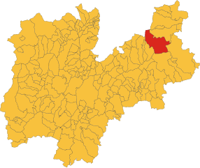
Нова-Поненте (Deutschnofen, Nova Ponente)
.svg)
- коммуна Италии
 Hiking in Нова-Поненте
Deutschnofen, known as "Naz-Sciaves" in Italian, is a charming village located in the South Tyrol region of northern Italy. Nestled in the stunning Dolomites, it offers a variety of hiking opportunities for enthusiasts of all levels. Here are some highlights of hiking in this beautiful area:
1. Trails and Terrain
Deutschnofen features a range of hiking trails that cater to different skill levels, from gentle walks to more challenging excursions. The trails often provide breathtaking views of the surrounding mountains, lush valleys, and charming alpine meadows.
2. Popular Hiking Routes
- Eisack Valley Trail: A scenic route that follows the river, showcasing the lush landscape and picturesque views.
- Gzerdell Alm: A lovely hike that leads to a mountain hut, perfect for enjoying a traditional Tyrolean meal after a rewarding trek.
- Kühtai: For those looking for a challenge, trails leading toward Kühtai offer stunning panoramic views and access to higher elevation terrains.
3. Nature and Wildlife
While hiking in Deutschnofen, you may encounter various alpine animals, such as chamois and marmots, along with a plethora of mountain flowers. The diversity of flora and fauna adds a rich layer to the hiking experience.
4. Seasonality
The best time for hiking in Deutschnofen is during the late spring to early fall months (May to October), when trails are generally clear of snow and weather conditions are more favorable. However, some higher trails may still have snow in early summer.
5. Local Culture and Accommodations
Deutschnofen is steeped in Tyrolean culture, and you can enjoy local cuisine and hospitality in the village. There are various accommodations, including hotels and bed-and-breakfasts, where you can relax and recharge after a day of hiking.
6. Safety Considerations
Always check the weather conditions before you head out and ensure you have appropriate gear for the hike. It’s wise to carry a map, sufficient water, and snacks, and let someone know your hiking plan.
Explore the beautiful landscapes, immerse yourself in nature, and enjoy the tranquility that hiking in Deutschnofen has to offer!
- Страна:

- Почтовый код: 39050
- Телефонный код: 0471
- Код автомобильного номера: BZ
- Координаты: 46° 24' 51" N, 11° 25' 31" E


- GPS треки (wikiloc): [Ссылка]
- Высота над уровнем моря: 1357 м m
- Площадь: 112.49 кв.км
- Население: 3917
- Веб сайт: http://www.comune.novaponente.bz.it/system/web/default.aspx?sprache=3
- Википедия русская: wiki(ru)
- Википедия английская: wiki(en)
- Википедия национальная: wiki(it)
- Хранилище Wikidata: Wikidata: Q433365
- Галерея изображений в википедии: [Ссылка]
- Катеория в википедии: [Ссылка]
- код Freebase: [/m/03t44q]
- код GeoNames: Альт: [6535914]
- код VIAF: Альт: [238974294]
- ID отношения в OpenStreetMap: [47145]
- код GND: Альт: [4011917-8]
- идентификатор местоположения ArchINFORM: [10174]
- код ISTAT: 021059
- кадастровый код Италии: F950
Граничит с регионами:


Лайвес
- коммуна Италии
Hiking in Лайвес
Laives (or Leifers in German) is a small town located in the South Tyrol region of northern Italy. It's situated near the city of Bolzano, making it a great base for hikers interested in exploring the stunning scenery of the Dolomites and the surrounding alpine landscape....
- Страна:
- Почтовый код: 39055
- Телефонный код: 0471
- Код автомобильного номера: BZ
- Координаты: 46° 25' 39" N, 11° 20' 26" E
- GPS треки (wikiloc): [Ссылка]
- Высота над уровнем моря: 258 м m
- Площадь: 24.11 кв.км
- Население: 17954
- Веб сайт: [Ссылка]

Предаццо
- коммуна Италии
Hiking in Предаццо
Predazzo is a beautiful town located in the Val di Fiemme in the Trentino region of northern Italy. It's a great destination for hiking enthusiasts, offering a variety of trails that cater to different skill levels, stunning landscapes, and rich biodiversity....
- Страна:
- Почтовый код: 38037
- Телефонный код: 0462
- Код автомобильного номера: TN
- Координаты: 46° 19' 0" N, 11° 36' 0" E
- GPS треки (wikiloc): [Ссылка]
- Высота над уровнем моря: 1018 м m
- Площадь: 109.97 кв.км
- Население: 4540
- Веб сайт: [Ссылка]


Тезеро
- коммуна Италии
Hiking in Тезеро
Tesero, located in the Fiemme Valley of the Trentino-Alto Adige region in northern Italy, is a great destination for hikers due to its stunning alpine scenery and a network of well-maintained trails. Here are some key points to consider for hiking in Tesero:...
- Страна:
- Почтовый код: 38038
- Телефонный код: 0462
- Код автомобильного номера: TN
- Координаты: 46° 17' 22" N, 11° 30' 41" E
- GPS треки (wikiloc): [Ссылка]
- Высота над уровнем моря: 1000 м m
- Площадь: 50.55 кв.км
- Население: 2940
- Веб сайт: [Ссылка]


Варена
- коммуна Италии
Hiking in Варена
Varena is a beautiful village located in the Trentino region of northern Italy, nestled in the Val di Fiemme valley. It's an excellent destination for hiking enthusiasts, offering a variety of trails that cater to different skill levels and showcasing the stunning Dolomitic landscapes and majestic alpine scenery....
- Страна:
- Почтовый код: 38030
- Телефонный код: 0462
- Код автомобильного номера: TN
- Координаты: 46° 18' 18" N, 11° 27' 32" E
- GPS треки (wikiloc): [Ссылка]
- Высота над уровнем моря: 1175 м m
- Площадь: 23.07 кв.км
- Население: 841
- Веб сайт: [Ссылка]


Альдино
- коммуна Италии
Hiking in Альдино
Aldein, located in the South Tyrol region of Northern Italy, is a wonderful destination for hiking enthusiasts. Nestled in the scenic mountains, it offers a variety of trails that cater to different skill levels, from leisurely walks to more challenging treks. Here are some highlights about hiking in Aldein:...
- Страна:
- Почтовый код: 39040
- Телефонный код: 0471
- Код автомобильного номера: BZ
- Координаты: 46° 22' 0" N, 11° 21' 0" E
- GPS треки (wikiloc): [Ссылка]
- Высота над уровнем моря: 1225 м m
- Площадь: 62.69 кв.км
- Население: 1664
- Веб сайт: [Ссылка]
Бронцоло
- коммуна Италии
Hiking in Бронцоло
Bronzolo, or Bronzolo in Italian, is a charming village located in South Tyrol, Italy. Nestled near the Adige River and surrounded by beautiful rolling hills and vineyards, it offers a fantastic experience for hiking enthusiasts. Here are some highlights about hiking in the Bronzolo area:...
- Страна:
- Почтовый код: 39051
- Телефонный код: 0471
- Код автомобильного номера: BZ
- Координаты: 46° 24' 0" N, 11° 19' 0" E
- GPS треки (wikiloc): [Ссылка]
- Высота над уровнем моря: 263 м m
- Площадь: 7.54 кв.км
- Население: 2798
- Веб сайт: [Ссылка]


Корнедо-алл'Изарко
- коммуна Италии
Hiking in Корнедо-алл'Изарко
Karneid, located in South Tyrol, Italy, offers beautiful hiking opportunities amidst stunning mountain landscapes. The region is known for its diverse trails that range from easy walks to challenging treks, making it suitable for hikers of all skill levels....
- Страна:
- Почтовый код: 39053
- Телефонный код: 0471
- Код автомобильного номера: BZ
- Координаты: 46° 30' 0" N, 11° 24' 0" E
- GPS треки (wikiloc): [Ссылка]
- Высота над уровнем моря: 510 м m
- Площадь: 40.61 кв.км
- Население: 3391
- Веб сайт: [Ссылка]


Нова-Леванте
- коммуна Италии
Hiking in Нова-Леванте
Welschnofen, located in the South Tyrol region of Italy, is a beautiful destination for hiking enthusiasts. Nestled in the Dolomites, this charming village offers a range of trails suited for all levels of hikers, from beginners to experienced adventurers. Here are some highlights of hiking in Welschnofen:...
- Страна:
- Почтовый код: 39056
- Телефонный код: 0471
- Код автомобильного номера: BZ
- Координаты: 46° 25' 44" N, 11° 32' 22" E
- GPS треки (wikiloc): [Ссылка]
- Высота над уровнем моря: 1182 м m
- Площадь: 51.1 кв.км
- Население: 1976
- Веб сайт: [Ссылка]


Больцано
- коммуна Италии
Hiking in Больцано
Bolzano, located in the northern part of Italy in the South Tyrol region, offers stunning hiking opportunities amidst the picturesque backdrop of the Dolomites and surrounding mountains. Here are some highlights and tips for hiking in Bolzano:...
- Страна:
- Почтовый код: 39100
- Телефонный код: 0471
- Код автомобильного номера: BZ
- Координаты: 46° 30' 0" N, 11° 21' 0" E
- GPS треки (wikiloc): [Ссылка]
- Высота над уровнем моря: 232 м m
- Площадь: 52.29 кв.км
- Население: 106951
- Веб сайт: [Ссылка]