Англефор (Anglefort, Anglefort)

- коммуна в департаменте Эн, Франция
 Hiking in Англефор
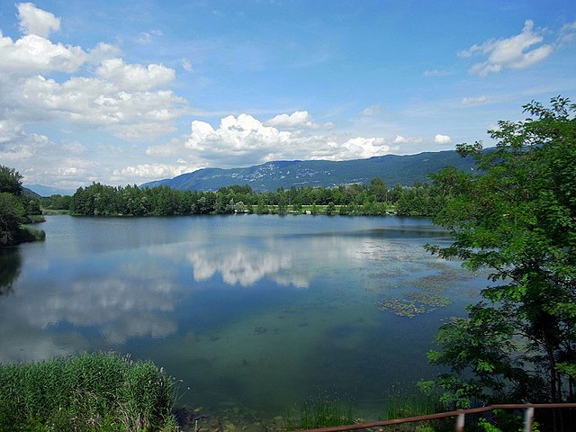
Anglefort is a picturesque town located in the Ain department of the Auvergne-Rhône-Alpes region in southeastern France. Nestled near the shores of Lake Bourget and surrounded by the breathtaking landscapes of the Jura mountains, Anglefort offers a variety of hiking opportunities for both novice and experienced hikers.
Hiking Trails and Areas:
-
Le Cirque de Saint-Même: This area features stunning cliffs and diverse flora. The trails here offer impressive views and a chance to experience the beauty of the natural landscape.
-
Mont du Chat: Located nearby, this mountain provides more challenging hikes with rewarding panoramic views of Lake Bourget and the surrounding mountains. The summit can be reached via well-marked trails.
-
Jura Mountains: The Jura range is known for its lush forests, limestone cliffs, and picturesque lakes. There are numerous marked trails ranging in difficulty, making it suitable for everyone.
-
Lake Bourget: Trails around the lake offer a more relaxed hiking experience, with beautiful views of the water and opportunities for bird-watching. The trails can also connect to other areas, providing longer routes for those looking for a more extensive adventure.
Tips for Hiking in Anglefort:
-
Seasonal Considerations: Spring and autumn are ideal for hiking due to mild temperatures and stunning foliage. Summer can be warmer, while winter may see snow, making some trails less accessible.
-
Trail Preparation: Always check local maps and trail markers before heading out. Make sure to wear suitable footwear and carry adequate water and snacks.
-
Safety: Inform someone of your hiking plans, especially if you are going into more remote areas. Familiarize yourself with the difficulty level of the trails you plan to hike.
-
Local Regulations: Be aware of and respect local conservation efforts and regulations. Stay on marked paths to help preserve the natural environment.
Whether you’re looking for a leisurely lakeside stroll or a vigorous climb in the Jura mountains, Anglefort has something to offer every hiking enthusiast. Enjoy the scenery and the fresh air!
- Страна:

- Почтовый код: 01350
- Координаты: 45° 54' 44" N, 5° 48' 32" E


- GPS треки (wikiloc): [Ссылка]
- Площадь: 29.26 кв.км
- Население: 1133
- Веб сайт: http://www.anglefort.fr
- Википедия русская: wiki(ru)
- Википедия английская: wiki(en)
- Википедия национальная: wiki(fr)
- Хранилище Wikidata: Wikidata: Q193996
- Катеория в википедии: [Ссылка]
- Карты в википедии: [Ссылка]
- код Freebase: [/m/07tnrj]
- код Freebase: [/m/07tnrj]
- код Freebase: [/m/07tnrj]
- код GeoNames: Альт: [6446361]
- код GeoNames: Альт: [6446361]
- код GeoNames: Альт: [6446361]
- номер SIREN: [210100103]
- номер SIREN: [210100103]
- номер SIREN: [210100103]
- код тезауруса PACTOLS: [pcrtnaTgiAUUv4]
- код тезауруса PACTOLS: [pcrtnaTgiAUUv4]
- код тезауруса PACTOLS: [pcrtnaTgiAUUv4]
- код муниципалитета INSEE: 01010
- код муниципалитета INSEE: 01010
- код муниципалитета INSEE: 01010
Граничит с регионами:

Корбоно
- коммуна во Франции
Hiking in Корбоно
Corbonod is a picturesque village located in the Auvergne-Rhône-Alpes region of southeastern France, nestled within the beautiful landscapes of the French Alps. Hiking in this area offers stunning views, diverse terrains, and a chance to explore the natural beauty of the region. Here are some things to consider when hiking in Corbonod:...
- Страна:
- Почтовый код: 01420
- Координаты: 45° 58' 11" N, 5° 48' 37" E
- GPS треки (wikiloc): [Ссылка]
- Площадь: 31.59 кв.км
- Население: 1246
- Веб сайт: [Ссылка]


Сесель
- коммуна во Франции, департамент Эн
Hiking in Сесель
Seyssel, located in the Ain department of the Auvergne-Rhône-Alpes region in France, offers a stunning backdrop for hiking enthusiasts. Nestled along the banks of the Rhône River and framed by mountains and beautiful landscapes, Seyssel provides diverse trails suitable for various skill levels. Here are some highlights about hiking in this area:...
- Страна:
- Почтовый код: 01420
- Координаты: 45° 57' 32" N, 5° 49' 52" E
- GPS треки (wikiloc): [Ссылка]
- Площадь: 2.4 кв.км
- Население: 990

Кюло
- коммуна во Франции
Hiking in Кюло
Culoz is a charming town located in the Auvergne-Rhône-Alpes region of France, nestled between the Jura mountains and the foothills of the Alps. This area offers a variety of hiking opportunities, providing stunning views and a chance to explore the natural beauty of the region. Here are some highlights of hiking in and around Culoz:...
- Страна:
- Почтовый код: 01350
- Координаты: 45° 50' 55" N, 5° 46' 54" E
- GPS треки (wikiloc): [Ссылка]
- Площадь: 19.36 кв.км
- Население: 3071
- Веб сайт: [Ссылка]

Вирьё-ле-Пети
- коммуна во Франции
Hiking in Вирьё-ле-Пети
Virieu-le-Petit is a charming village located in the Ain department of the Auvergne-Rhône-Alpes region in southeastern France. It offers beautiful landscapes, including rolling hills, forests, and opportunities for various outdoor activities, making it a wonderful destination for hiking enthusiasts....
- Страна:
- Почтовый код: 01260
- Координаты: 45° 54' 31" N, 5° 43' 28" E
- GPS треки (wikiloc): [Ссылка]
- Площадь: 16.36 кв.км
- Население: 302
- Веб сайт: [Ссылка]

Лошьё
- коммуна во Франции
Hiking in Лошьё
Lochieu is a small commune in the Auvergne-Rhône-Alpes region of southeastern France, surrounded by beautiful natural landscapes. While it may not be as widely known for hiking as some other areas in the French Alps, it offers opportunities for outdoor enthusiasts to explore the natural beauty of the region, including forests, hills, and scenic viewpoints....
- Страна:
- Почтовый код: 01260
- Координаты: 45° 55' 50" N, 5° 43' 40" E
- GPS треки (wikiloc): [Ссылка]
- Площадь: 7.07 кв.км
- Население: 93


Motz
- коммуна во Франции
Hiking in Motz
Motz, a small municipality located in the Savoie region of France, is nestled in the beautiful alpine environment near the Mont Blanc massif and the French Alps. This location is known for its stunning landscapes, picturesque mountains, and diverse hiking opportunities. Here are some key aspects of hiking in and around Motz:...
- Страна:
- Почтовый код: 73310
- Координаты: 45° 55' 11" N, 5° 50' 52" E
- GPS треки (wikiloc): [Ссылка]
- Площадь: 9.04 кв.км
- Население: 432
- Веб сайт: [Ссылка]

Serrières-en-Chautagne
- коммуна во Франции
Hiking in Serrières-en-Chautagne
Serrières-en-Chautagne, located in the Savoie department of the Auvergne-Rhône-Alpes region in France, offers beautiful hiking opportunities amidst picturesque landscapes. The region is known for its diverse terrain, including hills, forests, and proximity to Lake Bourget, which is the largest natural lake in France....
- Страна:
- Почтовый код: 73310
- Координаты: 45° 52' 56" N, 5° 50' 34" E
- GPS треки (wikiloc): [Ссылка]
- Площадь: 16.04 кв.км
- Население: 1212


Seyssel
Hiking in Seyssel
Seyssel, located in the Haute-Savoie region of France, is a charming town nestled at the confluence of the Rhône and the Fier rivers. It's surrounded by beautiful natural landscapes, making it a great destination for hiking enthusiasts. Here’s an overview of what you can expect when hiking in the Seyssel area:...
- Страна:
- Почтовый код: 74910
- Координаты: 45° 57' 32" N, 5° 50' 11" E
- GPS треки (wikiloc): [Ссылка]
- Площадь: 16.86 кв.км
- Население: 2290