Кюло (Culoz, Culoz)
- коммуна во Франции
 Hiking in Кюло
Culoz is a charming town located in the Auvergne-Rhône-Alpes region of France, nestled between the Jura mountains and the foothills of the Alps. This area offers a variety of hiking opportunities, providing stunning views and a chance to explore the natural beauty of the region. Here are some highlights of hiking in and around Culoz:
Trails and Nature:
-
Jura Mountains Trails: The Jura mountain range has numerous trails that cater to different skill levels. Some popular hikes include those that lead to panoramic viewpoints, waterfalls, and dense forests.
-
Lake Bourget: A short hike from Culoz will take you to Lake Bourget, the largest natural lake in France. The surrounding area offers scenic paths along the lake with opportunities for bird watching and enjoying the local flora.
-
Mont de la Charvaz: This is a popular hike for those looking for a challenge. The ascent rewards hikers with breathtaking views of the surrounding Alps and valleys.
-
Marked Hiking Trails: Culoz is well-served by the French hiking organization (Fédération Française de la Randonnée Pédestre), which maintains marked trails. It’s advisable to pick up a hiking map from local tourist offices for detailed routes and points of interest.
Tips for Hiking in Culoz:
-
Seasonal Considerations: Spring and early fall are ideal for hiking, as the weather is typically mild. Summer can be warm, so early morning or late evening hikes are preferable to avoid the heat.
-
Gear and Equipment: It’s important to wear appropriate hiking boots and clothing, and to carry sufficient water, snacks, a first aid kit, and, if necessary, trekking poles.
-
Local Guides: For those unfamiliar with the area, consider hiring a local guide or joining a group hike for a more informative and enriching experience, as they can provide insights into the local ecosystem, geology, and history.
-
Respect Nature: As always, practice Leave No Trace principles to preserve the beauty of the landscape for future hikers.
Conclusion:
Hiking in Culoz offers a mix of beautiful landscapes, serene lakes, and challenging mountain terrains. Whether you’re a beginner or an experienced hiker, you’ll find routes that suit your preferences and provide a wonderful opportunity to immerse yourself in the natural beauty of the French countryside. Always check weather conditions and trail statuses before heading out, and enjoy your adventure!
- Страна:

- Почтовый код: 01350
- Координаты: 45° 50' 55" N, 5° 46' 54" E


- GPS треки (wikiloc): [Ссылка]
- Площадь: 19.36 кв.км
- Население: 3071
- Веб сайт: http://www.culoz.fr
- Википедия русская: wiki(ru)
- Википедия английская: wiki(en)
- Википедия национальная: wiki(fr)
- Хранилище Wikidata: Wikidata: Q243597
- Катеория в википедии: [Ссылка]
- Карты в википедии: [Ссылка]
- код Freebase: [/m/08154p]
- код Freebase: [/m/08154p]
- код Freebase: [/m/08154p]
- код GeoNames: Альт: [3022093]
- код GeoNames: Альт: [3022093]
- код GeoNames: Альт: [3022093]
- номер SIREN: [210101382]
- номер SIREN: [210101382]
- номер SIREN: [210101382]
- код BNF: [136093269]
- код BNF: [136093269]
- код BNF: [136093269]
- код VIAF: Альт: [142026588]
- код VIAF: Альт: [142026588]
- код VIAF: Альт: [142026588]
- код GND: Альт: [4358534-6]
- код GND: Альт: [4358534-6]
- код GND: Альт: [4358534-6]
- код LCNAF: Альт: [n90659894]
- код LCNAF: Альт: [n90659894]
- код LCNAF: Альт: [n90659894]
- WOEID: [588207]
- WOEID: [588207]
- WOEID: [588207]
- код муниципалитета INSEE: 01138
- код муниципалитета INSEE: 01138
- код муниципалитета INSEE: 01138
Граничит с регионами:


Англефор
- коммуна в департаменте Эн, Франция
Hiking in Англефор
Anglefort is a picturesque town located in the Ain department of the Auvergne-Rhône-Alpes region in southeastern France. Nestled near the shores of Lake Bourget and surrounded by the breathtaking landscapes of the Jura mountains, Anglefort offers a variety of hiking opportunities for both novice and experienced hikers....
- Страна:
- Почтовый код: 01350
- Координаты: 45° 54' 44" N, 5° 48' 32" E
- GPS треки (wikiloc): [Ссылка]
- Площадь: 29.26 кв.км
- Население: 1133
- Веб сайт: [Ссылка]

Беон
- коммуна во Франции, департамент Эн
Hiking in Беон
Béon is a charming commune located in the Ain department in the Auvergne-Rhône-Alpes region of France. It is characterized by its picturesque landscapes, including rolling hills, forests, and scenic views of the surrounding countryside, making it a delightful destination for hiking enthusiasts....
- Страна:
- Почтовый код: 01350
- Координаты: 45° 51' 17" N, 5° 45' 19" E
- GPS треки (wikiloc): [Ссылка]
- Площадь: 10.3 кв.км
- Население: 475
- Веб сайт: [Ссылка]
Сейзерьё
- коммуна во Франции
Hiking in Сейзерьё
Ceyzérieu is a charming commune located in the Ain department of the Auvergne-Rhône-Alpes region in France. It's known for its picturesque countryside and proximity to the beautiful rolling hills and mountains of the Jura range, making it a great destination for hiking enthusiasts....
- Страна:
- Почтовый код: 01350
- Координаты: 45° 50' 6" N, 5° 43' 34" E
- GPS треки (wikiloc): [Ссылка]
- Площадь: 19.72 кв.км
- Население: 1016
- Веб сайт: [Ссылка]
Шаворне
- коммуна во Франции
Hiking in Шаворне
Chavornay, located in the Ain department of the Auvergne-Rhône-Alpes region in France, offers beautiful landscapes and a variety of hiking opportunities for all skill levels. Nestled among rolling hills, forests, and agricultural land, hiking in this area allows for a close encounter with nature as well as a glimpse into the region's culture and history....
- Страна:
- Почтовый код: 01510
- Координаты: 45° 52' 45" N, 5° 43' 11" E
- GPS треки (wikiloc): [Ссылка]
- Площадь: 7.77 кв.км
- Население: 220

Вирьё-ле-Пети
- коммуна во Франции
Hiking in Вирьё-ле-Пети
Virieu-le-Petit is a charming village located in the Ain department of the Auvergne-Rhône-Alpes region in southeastern France. It offers beautiful landscapes, including rolling hills, forests, and opportunities for various outdoor activities, making it a wonderful destination for hiking enthusiasts....
- Страна:
- Почтовый код: 01260
- Координаты: 45° 54' 31" N, 5° 43' 28" E
- GPS треки (wikiloc): [Ссылка]
- Площадь: 16.36 кв.км
- Население: 302
- Веб сайт: [Ссылка]

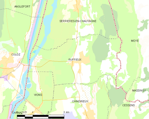
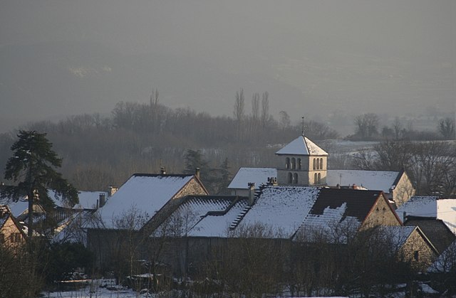
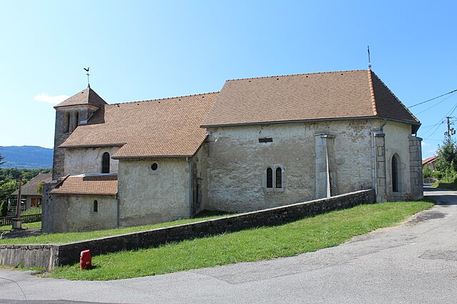
Ruffieux
- коммуна во Франции
Hiking in Ruffieux
Ruffieux is a charming village located in the Savoie department of the Auvergne-Rhône-Alpes region in southeastern France. It is nestled in the stunning landscape of the French Alps, providing hikers with a myriad of options for outdoor exploration....
- Страна:
- Почтовый код: 73310
- Координаты: 45° 50' 57" N, 5° 50' 38" E
- GPS треки (wikiloc): [Ссылка]
- Площадь: 13.21 кв.км
- Население: 856
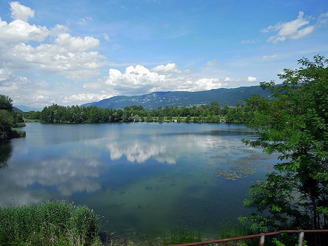

Serrières-en-Chautagne
- коммуна во Франции
Hiking in Serrières-en-Chautagne
Serrières-en-Chautagne, located in the Savoie department of the Auvergne-Rhône-Alpes region in France, offers beautiful hiking opportunities amidst picturesque landscapes. The region is known for its diverse terrain, including hills, forests, and proximity to Lake Bourget, which is the largest natural lake in France....
- Страна:
- Почтовый код: 73310
- Координаты: 45° 52' 56" N, 5° 50' 34" E
- GPS треки (wikiloc): [Ссылка]
- Площадь: 16.04 кв.км
- Население: 1212


Vions
- коммуна во Франции
Hiking in Vions
It seems there might be a typo in your query, as "Vions" does not correspond to a well-known hiking destination. However, if you meant "Vions" as a specific location or region, please provide a bit more context or clarify the name....
- Страна:
- Почтовый код: 73310
- Координаты: 45° 49' 28" N, 5° 48' 25" E
- GPS треки (wikiloc): [Ссылка]
- Площадь: 5.7 кв.км
- Население: 410

Лавур
- коммуна во Франции
Hiking in Лавур
Hiking in Lavours, a charming area in the Auvergne-Rhône-Alpes region of France, offers a delightful blend of stunning landscapes, rich flora and fauna, and the opportunity to experience the natural beauty of the French countryside. Lavours is particularly known for its beautiful trails that wind through the rolling hills and along the Rhone River....
- Страна:
- Почтовый код: 01350
- Координаты: 45° 48' 33" N, 5° 46' 21" E
- GPS треки (wikiloc): [Ссылка]
- Площадь: 6.3 кв.км
- Население: 129


Chanaz
- коммуна во Франции
Hiking in Chanaz
Chanaz, often referred to as the "Venice of the Savoy," is a picturesque village located in the Auvergne-Rhône-Alpes region of France, near the Rhône River and surrounded by stunning natural landscapes. The area is known for its scenic routes and opportunities for hiking, making it an excellent destination for outdoor enthusiasts....
- Страна:
- Почтовый код: 73310
- Координаты: 45° 48' 31" N, 5° 47' 35" E
- GPS треки (wikiloc): [Ссылка]
- Площадь: 6.75 кв.км
- Население: 507
- Веб сайт: [Ссылка]

Флаксьё
- коммуна во Франции
Hiking in Флаксьё
Flaxieu, located in the beautiful region of the French Alps, offers a variety of hiking opportunities that cater to all levels of hikers, from beginners to experienced trekkers. Here are some highlights to consider:...
- Страна:
- Почтовый код: 01350
- Координаты: 45° 48' 30" N, 5° 44' 7" E
- GPS треки (wikiloc): [Ссылка]
- Площадь: 2.79 кв.км
- Население: 67
- Веб сайт: [Ссылка]