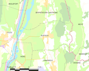
Serrières-en-Chautagne (Serrières-en-Chautagne)

- коммуна во Франции
 Hiking in Serrières-en-Chautagne
Serrières-en-Chautagne, located in the Savoie department of the Auvergne-Rhône-Alpes region in France, offers beautiful hiking opportunities amidst picturesque landscapes. The region is known for its diverse terrain, including hills, forests, and proximity to Lake Bourget, which is the largest natural lake in France.
Hiking Trails
-
Lake Bourget Trail: This trail runs along the shore of Lake Bourget, providing stunning views of the water and the surrounding mountains. It's relatively easy, making it suitable for families and beginners.
-
Mont de la Charvaz: A more challenging hike that takes you up to Mont de la Charvaz, where you'll be rewarded with panoramic views of the Alps and the lake below. The trail is well-marked and offers a mix of forest paths and open areas.
-
Chautagne Valleys: The trails that wind through the valleys around Serrières-en-Chautagne are perfect for those looking to explore the rural beauty of the area, with chances to see local wildlife and flora.
Tips for Hiking in Serrières-en-Chautagne
- Proper Gear: Make sure to wear appropriate hiking shoes and carry enough water and snacks, especially for longer trails.
- Weather Conditions: Check the weather forecast before heading out, as conditions can change rapidly in mountainous areas.
- Navigation: Familiarize yourself with the hiking maps of the area, or consider downloading a hiking app for offline navigation.
- Leave No Trace: Be mindful of the environment and always follow the Leave No Trace principles to preserve the natural beauty of the region.
Best Times to Hike
The best times to hike in Serrières-en-Chautagne are during the spring and early autumn when the weather is generally more favorable and the landscapes are particularly beautiful with blooming flowers and fall colors.
Local Attractions
After hiking, consider exploring the charming village of Serrières-en-Chautagne and enjoying local cuisine. There are also opportunities for other outdoor activities such as cycling, fishing, or simply relaxing by the lake.
Whether you're an experienced hiker or just looking for a leisurely walk, Serrières-en-Chautagne offers a delightful blend of natural beauty and serenity. Enjoy your outdoor adventure!
- Страна:

- Почтовый код: 73310
- Координаты: 45° 52' 56" N, 5° 50' 34" E


- GPS треки (wikiloc): [Ссылка]
- Площадь: 16.04 кв.км
- Население: 1212
- Википедия английская: wiki(en)
- Википедия национальная: wiki(fr)
- Хранилище Wikidata: Wikidata: Q685444
- Катеория в википедии: [Ссылка]
- код Freebase: [/m/03npfvh]
- код GeoNames: Альт: [6442907]
- номер SIREN: [217302868]
- код BNF: [15274216j]
- код муниципалитета INSEE: 73286
Граничит с регионами:


Англефор
- коммуна в департаменте Эн, Франция
Hiking in Англефор
Anglefort is a picturesque town located in the Ain department of the Auvergne-Rhône-Alpes region in southeastern France. Nestled near the shores of Lake Bourget and surrounded by the breathtaking landscapes of the Jura mountains, Anglefort offers a variety of hiking opportunities for both novice and experienced hikers....
- Страна:
- Почтовый код: 01350
- Координаты: 45° 54' 44" N, 5° 48' 32" E
- GPS треки (wikiloc): [Ссылка]
- Площадь: 29.26 кв.км
- Население: 1133
- Веб сайт: [Ссылка]

Кюло
- коммуна во Франции
Hiking in Кюло
Culoz is a charming town located in the Auvergne-Rhône-Alpes region of France, nestled between the Jura mountains and the foothills of the Alps. This area offers a variety of hiking opportunities, providing stunning views and a chance to explore the natural beauty of the region. Here are some highlights of hiking in and around Culoz:...
- Страна:
- Почтовый код: 01350
- Координаты: 45° 50' 55" N, 5° 46' 54" E
- GPS треки (wikiloc): [Ссылка]
- Площадь: 19.36 кв.км
- Население: 3071
- Веб сайт: [Ссылка]


Motz
- коммуна во Франции
Hiking in Motz
Motz, a small municipality located in the Savoie region of France, is nestled in the beautiful alpine environment near the Mont Blanc massif and the French Alps. This location is known for its stunning landscapes, picturesque mountains, and diverse hiking opportunities. Here are some key aspects of hiking in and around Motz:...
- Страна:
- Почтовый код: 73310
- Координаты: 45° 55' 11" N, 5° 50' 52" E
- GPS треки (wikiloc): [Ссылка]
- Площадь: 9.04 кв.км
- Население: 432
- Веб сайт: [Ссылка]

Ruffieux
- коммуна во Франции
Hiking in Ruffieux
Ruffieux is a charming village located in the Savoie department of the Auvergne-Rhône-Alpes region in southeastern France. It is nestled in the stunning landscape of the French Alps, providing hikers with a myriad of options for outdoor exploration....
- Страна:
- Почтовый код: 73310
- Координаты: 45° 50' 57" N, 5° 50' 38" E
- GPS треки (wikiloc): [Ссылка]
- Площадь: 13.21 кв.км
- Население: 856


Moye
- коммуна во Франции
Hiking in Moye
Moye is a beautiful area for hiking, known for its diverse landscapes and natural beauty. While I don’t have specific information on a location named Moye, it typically refers to various places, sometimes in Europe or other regions. If Moye is somewhere you have in mind, here are some general tips and considerations for hiking in such an area:...
- Страна:
- Почтовый код: 74150
- Координаты: 45° 52' 35" N, 5° 54' 43" E
- GPS треки (wikiloc): [Ссылка]
- Площадь: 23.8 кв.км
- Население: 1030


Lornay
- коммуна во Франции
Hiking in Lornay
Lornay is a picturesque area located in the Auvergne-Rhône-Alpes region of France. It is characterized by its natural beauty, offering a variety of landscapes ranging from rolling hills to lush forests. Here are some key points about hiking in Lornay:...
- Страна:
- Почтовый код: 74150
- Координаты: 45° 54' 59" N, 5° 54' 6" E
- GPS треки (wikiloc): [Ссылка]
- Площадь: 9.65 кв.км
- Население: 536