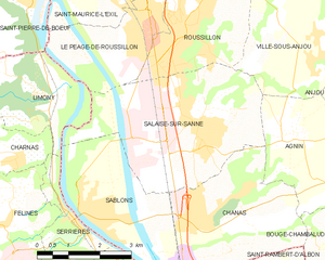
Анжу (Anjou, Anjou)

- коммуна во Франции
 Hiking in Анжу
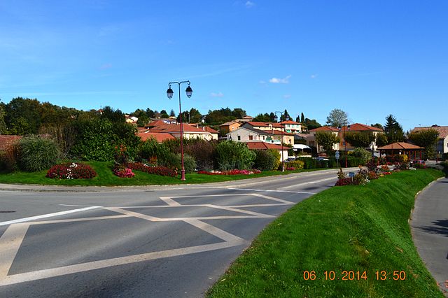
Anjou, located in the Isère department in the Auvergne-Rhône-Alpes region of southeastern France, offers a variety of beautiful landscapes and hiking opportunities. The area is known for its picturesque scenery, mixed forests, rolling hills, and views of the surrounding mountains, including the Alps.
Hiking Highlights in Anjou, Isère:
-
Scenic Trails: There are numerous well-marked trails in and around Anjou that cater to various skill levels, from easy walks suitable for families to more challenging hikes for experienced trekkers.
-
Natural Parks: The area is close to natural parks such as the Vercors Regional Natural Park and the Chartreuse Regional Natural Park, which provide additional options for hiking, with diverse ecosystems, wildlife, and breathtaking landscapes.
-
Cultural Heritage: While hiking in Anjou, you might encounter historical sites, charming villages, and local vineyards, which can add an interesting cultural component to your outdoor adventures.
-
Flora and Fauna: The region is rich in biodiversity. As you hike, keep an eye out for various plant and animal species native to the area, especially in the protected areas and nature reserves.
-
Rivers and Lakes: Many trails lead you along the Isère River and other smaller bodies of water, perfect for taking breaks or enjoying a picnic amidst nature.
Tips for Hiking in Anjou:
-
Weather Considerations: Always check the weather before setting out, and dress in layers, as temperatures can vary significantly throughout the day.
-
Trail Maps: It's helpful to have a map or a GPS-enabled device, as some trails can be less marked than others.
-
Hydration and Snacks: Bring plenty of water and some snacks to keep your energy up during your hikes.
-
Local Regulations: Be aware of any local rules, especially in protected areas, to ensure that you’re respecting nature and wildlife.
-
Hiking Season: Spring and fall are particularly beautiful times to hike in this region due to mild temperatures and vibrant foliage.
Whether you’re seeking a peaceful walk through nature or a challenging hike with spectacular views, Anjou in Isère has something to offer for every outdoor enthusiast. Enjoy your adventure!
- Страна:

- Почтовый код: 38150
- Координаты: 45° 20' 49" N, 4° 52' 55" E


- GPS треки (wikiloc): [Ссылка]
- Высота над уровнем моря: 182 м m
- Площадь: 5.03 кв.км
- Население: 1012
- Веб сайт: http://www.commune-anjou.fr
- Википедия русская: wiki(ru)
- Википедия английская: wiki(en)
- Википедия национальная: wiki(fr)
- Хранилище Wikidata: Wikidata: Q960503
- Катеория в википедии: [Ссылка]
- код Freebase: [/m/03g_7ms]
- код GeoNames: Альт: [6455382]
- номер SIREN: [213800097]
- код BNF: [15257838t]
- код GND: Альт: [4278419-0]
- код муниципалитета INSEE: 38009
Граничит с регионами:


Буже-Шамбалю
- коммуна во Франции
Hiking in Буже-Шамбалю
Bougé-Chambalud is a picturesque village located in the Auvergne-Rhône-Alpes region of France, specifically within the department of Drôme. Its setting offers several opportunities for hiking and enjoying the natural beauty of the area....
- Страна:
- Почтовый код: 38150
- Координаты: 45° 19' 49" N, 4° 54' 5" E
- GPS треки (wikiloc): [Ссылка]
- Площадь: 15.85 кв.км
- Население: 1395
- Веб сайт: [Ссылка]

Салез-сюр-Санн
- коммуна во Франции
- Страна:
- Почтовый код: 38150
- Координаты: 45° 20' 40" N, 4° 49' 9" E
- GPS треки (wikiloc): [Ссылка]
- Площадь: 16.15 кв.км
- Население: 4551
- Веб сайт: [Ссылка]

Аньен
- коммуна во Франции
- Страна:
- Почтовый код: 38150
- Координаты: 45° 20' 24" N, 4° 51' 26" E
- GPS треки (wikiloc): [Ссылка]
- Площадь: 7.96 кв.км
- Население: 1091
- Веб сайт: [Ссылка]


Виль-су-Анжу
- коммуна во Франции
Hiking in Виль-су-Анжу
Ville-sous-Anjou, located in the Auvergne-Rhône-Alpes region of France, offers a variety of beautiful hiking trails that showcase the natural beauty of the surrounding landscape. While specific trails in Ville-sous-Anjou may not be widely documented, the region is known for its picturesque countryside, rolling hills, and proximity to national parks and natural reserves. Here are some key points to consider when hiking in this area:...
- Страна:
- Почтовый код: 38150
- Координаты: 45° 21' 43" N, 4° 51' 49" E
- GPS треки (wikiloc): [Ссылка]
- Площадь: 18.25 кв.км
- Население: 1203


Сонне
- коммуна во Франции
Hiking in Сонне
Sonnay is a charming village located in the Isère department of the Auvergne-Rhône-Alpes region in southeastern France. While Sonnay itself may not be as well-known as some other hiking destinations, it serves as a great starting point for exploring the surrounding natural beauty of the region....
- Страна:
- Почтовый код: 38150
- Координаты: 45° 21' 17" N, 4° 54' 25" E
- GPS треки (wikiloc): [Ссылка]
- Площадь: 14.17 кв.км
- Население: 1236
- Веб сайт: [Ссылка]