
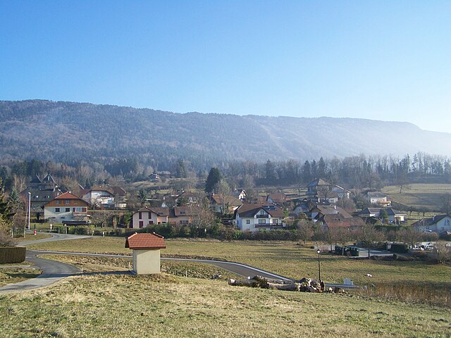
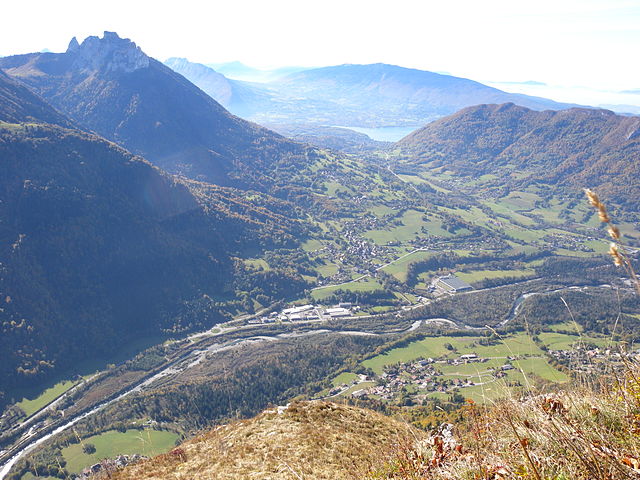
Анси (Annecy, Annecy)


- коммуна Франции
 Hiking in Анси
Hiking in Annecy, a picturesque town located in the French Alps, offers stunning landscapes, beautiful lakes, and a variety of trails suitable for different levels of experience. The area is renowned for its natural beauty, charming views, and outdoor activities.
Popular Hiking Trails in Annecy:
-
Col de la Forclaz:
- Difficulty: Moderate
- A popular hiking spot that provides breathtaking panoramic views of Lake Annecy and the surrounding mountains. The trail is accessible from several points and offers different routes, making it versatile for hikers.
-
Semnoz:
- Difficulty: Easy to Moderate
- This mountain range is ideal for family hikes and offers well-marked trails. In addition to the stunning views of Lake Annecy, you can enjoy a variety of flora and fauna along the way.
-
Mont Veyrier:
- Difficulty: Moderate to Challenging
- This hike takes you to an elevation where you can enjoy incredible views of Annecy and its lake. The trail features steep sections, but the panoramic vistas are well worth the effort.
-
Lake Annecy Circuit:
- Difficulty: Easy
- A leisurely and scenic walk around Lake Annecy. This flat loop is perfect for families and offers opportunities for picnicking, swimming, and taking in the vibrant colors of the lake and surrounding areas.
-
Les Dents de Lanfon:
- Difficulty: Challenging
- For more experienced hikers, this route leads to an impressive rocky peak (Dents de Lanfon) with challenging ascents and rewarding views from the top.
Tips for Hiking in Annecy:
-
Best Time to Hike: The best seasons for hiking in Annecy are late spring through early fall (May to October) when the weather is mild and the paths are accessible.
-
Preparation: Always check the weather conditions before heading out and prepare accordingly. Bring sufficient water, snacks, and a map or GPS device.
-
Safety: Make sure to wear appropriate hiking footwear, and be mindful of trail markings. If you're planning to hike alone or on more challenging routes, inform someone about your plans.
-
Respect Nature: Follow the Leave No Trace principles to preserve the beautiful environment.
-
Local Guidance: Consider joining guided hikes if you are unfamiliar with the area, as local guides can provide valuable insights and enhance your experience.
Hiking in Annecy provides a perfect combination of physical activity and nature appreciation, making it a wonderful experience for outdoor enthusiasts.
- Страна:

- Почтовый код: 74960; 74940; 74600; 74370; 74000
- Координаты: 45° 53' 57" N, 6° 7' 46" E


- GPS треки (wikiloc): [Ссылка]
- Высота над уровнем моря: 448 м m
- Площадь: 66.94 кв.км
- Население: 125694
- Веб сайт: http://www.annecy.fr
- Википедия русская: wiki(ru)
- Википедия английская: wiki(en)
- Википедия национальная: wiki(fr)
- Хранилище Wikidata: Wikidata: Q50189
- Галерея изображений в википедии: [Ссылка]
- Катеория в википедии: [Ссылка]
- Карты в википедии: [Ссылка]
- код Freebase: [/m/02jsr9]
- код GeoNames: Альт: [3037543]
- номер SIREN: [217400100]
- код BNF: [15274270b]
- код VIAF: Альт: [147744785]
- код GND: Альт: [4002122-1]
- идентификатор местоположения ArchINFORM: [545]
- код LCNAF: Альт: [n80072433]
- место в MusicBrainz: [ca796704-13f7-442b-869d-2ea07dcec459]
- код темы Quora: [Annecy-France]
- код SUDOC: [111030471]
- код в энциклопедии «Британника онлайн»: [place/Annecy]
- код в Encyclopædia Universalis: [annecy]
- идентификатор HDS: [7158]
- EMLO location ID: [d3988542-b7db-4dd5-bf4b-b687b5a046b5]
- код места в Facebook: [108129215874684]
- код в Большой российской энциклопедии онлайн: [695559]
- dmoz: Альт: [Regional/Europe/France/Regions/Rhone-Alpes/Haute-Savoie/Localities/Annecy/]
- код канала YouTube: [UCEqMHglMQmhEeY7hcIDO4cA]
- код муниципалитета INSEE: 74010
Граничит с регионами:

Кенталь
- коммуна во Франции
Hiking in Кенталь
Quintal, located in Haute-Savoie, France, is a charming village surrounded by stunning natural landscapes, making it a great starting point for hiking enthusiasts. The area is characterized by its picturesque mountains, lush forests, and panoramic views of Lake Annecy and the surrounding Alps....
- Страна:
- Почтовый код: 74600
- Координаты: 45° 50' 25" N, 6° 5' 8" E
- GPS треки (wikiloc): [Ссылка]
- Площадь: 9.13 кв.км
- Население: 1209
- Веб сайт: [Ссылка]


Chapeiry
- коммуна во Франции
Hiking in Chapeiry
Chapeiry is a picturesque village located in the Auvergne-Rhône-Alpes region of France, nestled near the beautiful Lake Geneva. It offers stunning natural scenery that is ideal for hiking enthusiasts. Here are some key things to know about hiking in Chapeiry:...
- Страна:
- Почтовый код: 74540
- Координаты: 45° 50' 44" N, 6° 2' 15" E
- GPS треки (wikiloc): [Ссылка]
- Площадь: 5.76 кв.км
- Население: 775
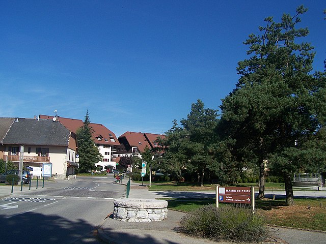

Poisy
- коммуна во Франции
Hiking in Poisy
Poisy, located near Annecy in the Auvergne-Rhône-Alpes region of France, offers beautiful hiking opportunities with stunning views of the surrounding mountains and Lake Annecy. Here are some things to consider if you’re planning to hike in and around Poisy:...
- Страна:
- Почтовый код: 74330
- Координаты: 45° 55' 20" N, 6° 3' 47" E
- GPS треки (wikiloc): [Ссылка]
- Площадь: 11.33 кв.км
- Население: 7594
- Веб сайт: [Ссылка]


Nâves-Parmelan
- коммуна во Франции
Hiking in Nâves-Parmelan
Nâves-Parmelan is a picturesque commune located in the Haute-Savoie region of France, nestled in the foothills of the French Alps. The area offers a range of hiking trails suited for various skill levels, making it a great destination for outdoor enthusiasts....
- Страна:
- Почтовый код: 74370
- Координаты: 45° 56' 2" N, 6° 11' 24" E
- GPS треки (wikiloc): [Ссылка]
- Площадь: 5.39 кв.км
- Население: 965
- Веб сайт: [Ссылка]


Montagny-les-Lanches
- коммуна во Франции
Hiking in Montagny-les-Lanches
Montagny-les-Lanches, located in the Auvergne-Rhône-Alpes region of France, offers a range of hiking opportunities set against a backdrop of stunning natural landscapes. While it may not be as widely known as some other hiking destinations in the Alps, the area provides beautiful trails that cater to different skill levels....
- Страна:
- Почтовый код: 74600
- Координаты: 45° 51' 41" N, 6° 2' 41" E
- GPS треки (wikiloc): [Ссылка]
- Площадь: 4.38 кв.км
- Население: 699

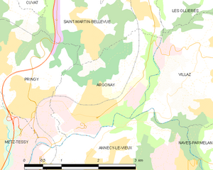
Argonay
- коммуна во Франции
Hiking in Argonay
Argonay is a picturesque commune located in the Haute-Savoie department of France, near Annecy. The area offers a variety of outdoor activities, including hiking, thanks to its beautiful landscapes and proximity to the French Alps....
- Страна:
- Почтовый код: 74370
- Координаты: 45° 56' 43" N, 6° 8' 25" E
- GPS треки (wikiloc): [Ссылка]
- Площадь: 5.16 кв.км
- Население: 2734
- Веб сайт: [Ссылка]


Верье-дю-Лак
- коммуна во Франции
Hiking in Верье-дю-Лак
Veyrier-du-Lac, located in the Haute-Savoie region of France, is a beautiful lakeside village situated along the eastern shore of Lake Annecy. It offers stunning natural landscapes, making it an excellent destination for hiking enthusiasts....
- Страна:
- Почтовый код: 74290
- Координаты: 45° 52' 53" N, 6° 10' 38" E
- GPS треки (wikiloc): [Ссылка]
- Площадь: 8.21 кв.км
- Население: 2308
- Веб сайт: [Ссылка]

Alex
- коммуна во Франции
Hiking in Alex
Alex is a charming village located in the Haute-Savoie region of the Auvergne-Rhône-Alpes in southeastern France. Nestled in the beautiful French Alps, it serves as a great starting point for various hiking adventures, offering stunning views and diverse landscapes. Here are some highlights about hiking in and around Alex:...
- Страна:
- Почтовый код: 74290
- Координаты: 45° 53' 20" N, 6° 14' 18" E
- GPS треки (wikiloc): [Ссылка]
- Площадь: 17.02 кв.км
- Население: 1031


Sevrier
- коммуна во Франции
Hiking in Sevrier
Sévrier is a picturesque commune located near Annecy in the Haute-Savoie region of France. It is well-known for its stunning natural beauty and offers various hiking opportunities that cater to different skill levels. Here are some highlights about hiking in the Sévrier area:...
- Страна:
- Почтовый код: 74320
- Координаты: 45° 51' 52" N, 6° 8' 23" E
- GPS треки (wikiloc): [Ссылка]
- Площадь: 12.65 кв.км
- Население: 4156
- Веб сайт: [Ссылка]

Dingy-Saint-Clair
- коммуна во Франции
Hiking in Dingy-Saint-Clair
Dingy-Saint-Clair is a charming commune in the Haute-Savoie region of the French Alps, known for its beautiful landscapes and outdoor activities, including hiking. Here are some key points to consider if you're planning to hike in this area:...
- Страна:
- Почтовый код: 74230
- Координаты: 45° 54' 42" N, 6° 13' 20" E
- GPS треки (wikiloc): [Ссылка]
- Площадь: 34.12 кв.км
- Население: 1395


Cuvat
- коммуна во Франции
Hiking in Cuvat
Cuvat is not widely recognized as a prominent hiking destination, as it might be a less-known locale or a misspelling of a more popular region. However, if you are referring to a specific area or a different name, please provide more context....
- Страна:
- Почтовый код: 74350
- Координаты: 45° 58' 39" N, 6° 7' 8" E
- GPS треки (wikiloc): [Ссылка]
- Площадь: 4.72 кв.км
- Население: 1213
- Веб сайт: [Ссылка]

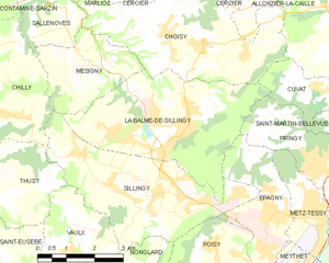
La Balme-de-Sillingy
- коммуна во Франции
Hiking in La Balme-de-Sillingy
La Balme-de-Sillingy, located in the Haute-Savoie region of France, offers some lovely hiking opportunities amidst beautiful Alpine scenery. The area is characterized by rolling hills, lush forests, and stunning views of the surrounding mountains, making it a delightful spot for both casual walkers and more experienced hikers....
- Страна:
- Почтовый код: 74330
- Координаты: 45° 57' 40" N, 6° 2' 31" E
- GPS треки (wikiloc): [Ссылка]
- Площадь: 16.51 кв.км
- Население: 5027
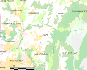
Villaz
- коммуна во Франции
Hiking in Villaz
Villaz is a village located in the Haute-Savoie region of France, near the scenic French Alps. It's an excellent base for hikers looking to explore the surrounding mountainous terrain, enjoy breathtaking views, and experience the beauty of nature....
- Страна:
- Почтовый код: 74370
- Координаты: 45° 57' 4" N, 6° 11' 23" E
- GPS треки (wikiloc): [Ссылка]
- Площадь: 15.27 кв.км
- Население: 3399
- Веб сайт: [Ссылка]

Шавано
- коммуна во Франции
Hiking in Шавано
Chavanod is a picturesque commune located in the Haute-Savoie region of France, which is surrounded by stunning natural landscapes, making it a great destination for hiking enthusiasts. The area acts as a gateway to beautiful trails and offers a variety of routes for different skill levels, from simple walks to more challenging hikes....
- Страна:
- Почтовый код: 74650
- Координаты: 45° 53' 24" N, 6° 2' 23" E
- GPS треки (wikiloc): [Ссылка]
- Площадь: 13.36 кв.км
- Население: 2545
- Веб сайт: [Ссылка]


Viuz-la-Chiésaz
- коммуна во Франции
Hiking in Viuz-la-Chiésaz
Viuz-la-Chiésaz, located in the Haute-Savoie region of France, is a picturesque area offering beautiful hiking opportunities. Nestled near the mountains and surrounded by nature, this small village provides access to various trails that cater to different skill levels, from leisurely walks to more challenging hikes....
- Страна:
- Почтовый код: 74540
- Координаты: 45° 48' 39" N, 6° 3' 42" E
- GPS треки (wikiloc): [Ссылка]
- Площадь: 13.91 кв.км
- Население: 1342