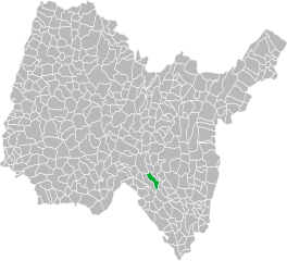
Аранда (Arandas, Arandas)
- коммуна в департаменте Эн, Франция
Arandas, located in the Ain department in the Auvergne-Rhône-Alpes region of France, offers some stunning hiking opportunities with a mix of beautiful landscapes and diverse terrain. The area is characterized by rolling hills, valleys, and a variety of flora and fauna, making it ideal for both casual walkers and more experienced hikers.
Hiking Trails in Arandas:
-
Local Trails: There are numerous marked trails around Arandas that range from easy, family-friendly walks to more challenging hikes. It's a good idea to check local maps and signage for specific trail information.
-
Forests and Natural Areas: The surrounding forests provide ample opportunities for shaded hiking. Trails often lead through beech and oak forests, where you can also enjoy birdwatching.
-
Regional Parks: Arandas is close to several regional parks, such as the Parc Naturel Régional du Haut-Jura. This park features a range of hiking trails and scenic viewpoints that offer breathtaking views of the Jura Mountains.
-
Cultural Walks: Some trails combine hiking with cultural experiences, offering the chance to explore local history, architecture, and gastronomy along the way.
Tips for Hiking in Arandas:
-
Map and Compass: Always carry a map and compass, or use a reliable GPS device, as trails can sometimes be unclear or unmarked.
-
Weather Preparedness: The weather can change quickly in the mountains, so check the forecast and dress in layers. Bring rain gear just in case.
-
Hydration and Nutrition: Carry enough water and snacks, especially for longer hikes. It’s easy to underestimate the exertion when exploring.
-
Wildlife Awareness: Be aware of local wildlife and practice Leave No Trace principles to protect the natural environment.
-
Timing: If you're planning to hike in the cooler months, be aware that some trails may be more difficult due to snow or mud.
Local Resources:
-
Tourist Information Centers: Visit local tourist offices to get trail maps, brochures, and advice from knowledgeable staff.
-
Guided Tours: If you're unfamiliar with the area or prefer not to hike alone, consider joining a guided hiking tour.
Hiking in Arandas can be a rewarding experience, offering a chance to enjoy nature, get some exercise, and discover the beauty of the Ain region. Enjoy your hike!
- Страна:

- Почтовый код: 01230
- Координаты: 45° 53' 42" N, 5° 29' 11" E


- GPS треки (wikiloc): [Ссылка]
- Площадь: 14.1 кв.км
- Население: 153
- Википедия русская: wiki(ru)
- Википедия английская: wiki(en)
- Википедия национальная: wiki(fr)
- Хранилище Wikidata: Wikidata: Q211635
- Катеория в википедии: [Ссылка]
- Карты в википедии: [Ссылка]
- код Freebase: [/m/07tntf]
- код Freebase: [/m/07tntf]
- код Freebase: [/m/07tntf]
- код GeoNames: Альт: [6446364]
- код GeoNames: Альт: [6446364]
- код GeoNames: Альт: [6446364]
- номер SIREN: [210100137]
- номер SIREN: [210100137]
- номер SIREN: [210100137]
- код муниципалитета INSEE: 01013
- код муниципалитета INSEE: 01013
- код муниципалитета INSEE: 01013
Граничит с регионами:


Аржи
- коммуна в департаменте Эн, Франция
It seems there might be a typo or misunderstanding in your request, as there isn't a well-known hiking area specifically called "Argis." However, if you meant "Argyll," which is located in Scotland, I can provide information on hiking there. If you meant a different location, please clarify, and I would be happy to assist!...
- Страна:

- Почтовый код: 01230
- Координаты: 45° 56' 2" N, 5° 29' 28" E


- GPS треки (wikiloc): [Ссылка]
- Площадь: 7.84 кв.км
- Население: 433

Сен-Рамбер-ан-Бюже
- коммуна во Франции
Saint-Rambert-en-Bugey is a charming commune located in the Ain department in the Auvergne-Rhône-Alpes region of France. The area is known for its natural beauty, making it a great spot for hiking enthusiasts. Here are some key points about hiking in and around Saint-Rambert-en-Bugey:...
- Страна:

- Почтовый код: 01230
- Координаты: 45° 56' 55" N, 5° 26' 17" E


- GPS треки (wikiloc): [Ссылка]
- Площадь: 28.55 кв.км
- Население: 2311
- Веб сайт: [Ссылка]

Ла-Бюрбанш
- коммуна во Франции
La Burbanche is a picturesque mountainous region located in the Rhône-Alpes area of France, known for its beautiful landscapes, scenic views, and hiking opportunities. It is situated near the Chartreuse Mountains and offers a variety of trails suitable for different skill levels, making it an excellent destination for hikers....
- Страна:

- Почтовый код: 01510
- Координаты: 45° 50' 48" N, 5° 33' 38" E


- GPS треки (wikiloc): [Ссылка]
- Площадь: 10.82 кв.км
- Население: 71

Тене
- коммуна во Франции, департамент Эн
Hiking in Tenaya, often associated with Tenaya Lake and the Tioga Pass area in Yosemite National Park, offers some spectacular opportunities for outdoor enthusiasts. Here are some highlights and tips for hiking in this beautiful region:...
- Страна:

- Почтовый код: 01230
- Координаты: 45° 55' 12" N, 5° 30' 30" E


- GPS треки (wikiloc): [Ссылка]
- Площадь: 13.12 кв.км
- Население: 1053
- Веб сайт: [Ссылка]

Конан
- коммуна во Франции
Conand, located in the Ain department in the Auvergne-Rhône-Alpes region of France, offers a picturesque setting for hiking enthusiasts. While Conand itself is a small commune, it is surrounded by beautiful landscapes, including rolling hills, forests, and nearby mountains....
- Страна:

- Почтовый код: 01230
- Координаты: 45° 53' 33" N, 5° 28' 16" E


- GPS треки (wikiloc): [Ссылка]
- Площадь: 15.28 кв.км
- Население: 118

Ордонна
- коммуна во Франции
Ordonnaz is a small commune located in the Auvergne-Rhône-Alpes region of southeastern France, nestled at the foot of the Alps. This area offers picturesque landscapes, making it a delightful destination for hiking enthusiasts....
- Страна:

- Почтовый код: 01510
- Координаты: 45° 50' 14" N, 5° 32' 18" E


- GPS треки (wikiloc): [Ссылка]
- Площадь: 14.88 кв.км
- Население: 152

