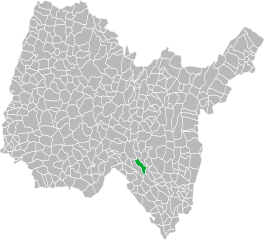
Конан (Conand, Conand)
- коммуна во Франции
 Hiking in Конан
Conand, located in the Ain department in the Auvergne-Rhône-Alpes region of France, offers a picturesque setting for hiking enthusiasts. While Conand itself is a small commune, it is surrounded by beautiful landscapes, including rolling hills, forests, and nearby mountains.
Hiking Options in Conand and Surrounding Areas:
-
Scenic Trails: The area provides numerous trails that cater to various skill levels, from easy strolls to more challenging hikes. You can enjoy the diverse flora and fauna, and stunning views of the French countryside.
-
Nearby Regions: Conand's proximity to the Jura Mountains makes it an ideal starting point for hikes leading into this scenic area. Trails in the Jura offer stunning vistas, waterfalls, and the opportunity to explore more rugged terrain.
-
Local Resources: Check in with local tourist offices or hiking clubs for maps and guided tours. They often provide up-to-date information on trail conditions, difficulty levels, and recommend scenic routes.
-
Nature Observations: The region is rich in biodiversity, making it a great spot for bird watching and enjoying nature photography along the trails.
-
Historical Sites: Some hikes may lead you to historical landmarks or quaint villages, allowing you to immerse yourself in the local culture and history.
Hiking Tips:
- Prepare for Varying Weather: The weather can change rapidly, so bring layers and check forecasts.
- Stay Hydrated and Energized: Carry sufficient water and snacks to keep your energy levels up during your hike.
- Navigation: Ensure you have a good map or a GPS device, as some trails may not be well marked.
- Respect Nature: Stay on designated trails, and follow local regulations to protect the environment.
Whether you're looking for a leisurely walk or a more intense hiking experience, Conand and the surrounding region has plenty to offer. If you're planning a visit, be sure to take time to explore various trails and enjoy the natural beauty of the area!
- Страна:

- Почтовый код: 01230
- Координаты: 45° 53' 33" N, 5° 28' 16" E


- GPS треки (wikiloc): [Ссылка]
- Площадь: 15.28 кв.км
- Население: 118
- Википедия русская: wiki(ru)
- Википедия английская: wiki(en)
- Википедия национальная: wiki(fr)
- Хранилище Wikidata: Wikidata: Q838732
- Катеория в википедии: [Ссылка]
- Карты в википедии: [Ссылка]
- код Freebase: [/m/0814x8]
- код Freebase: [/m/0814x8]
- код Freebase: [/m/0814x8]
- код GeoNames: Альт: [6424490]
- код GeoNames: Альт: [6424490]
- код GeoNames: Альт: [6424490]
- номер SIREN: [210101119]
- номер SIREN: [210101119]
- номер SIREN: [210101119]
- код муниципалитета INSEE: 01111
- код муниципалитета INSEE: 01111
- код муниципалитета INSEE: 01111
Граничит с регионами:

Бенонс
- коммуна во Франции
Hiking in Бенонс
Bénonces, a lesser-known area for hiking, is blessed with natural beauty and a variety of trails that cater to different skill levels. While specific details about Bénonces might not be widely documented, you can generally expect the following when hiking in similar regions:...
- Страна:
- Почтовый код: 01470
- Координаты: 45° 49' 40" N, 5° 28' 31" E
- GPS треки (wikiloc): [Ссылка]
- Площадь: 15.33 кв.км
- Население: 288
- Веб сайт: [Ссылка]

Аранда
- коммуна в департаменте Эн, Франция
Hiking in Аранда
Arandas, located in the Ain department in the Auvergne-Rhône-Alpes region of France, offers some stunning hiking opportunities with a mix of beautiful landscapes and diverse terrain. The area is characterized by rolling hills, valleys, and a variety of flora and fauna, making it ideal for both casual walkers and more experienced hikers....
- Страна:
- Почтовый код: 01230
- Координаты: 45° 53' 42" N, 5° 29' 11" E
- GPS треки (wikiloc): [Ссылка]
- Площадь: 14.1 кв.км
- Население: 153

Сен-Рамбер-ан-Бюже
- коммуна во Франции
Hiking in Сен-Рамбер-ан-Бюже
Saint-Rambert-en-Bugey is a charming commune located in the Ain department in the Auvergne-Rhône-Alpes region of France. The area is known for its natural beauty, making it a great spot for hiking enthusiasts. Here are some key points about hiking in and around Saint-Rambert-en-Bugey:...
- Страна:
- Почтовый код: 01230
- Координаты: 45° 56' 55" N, 5° 26' 17" E
- GPS треки (wikiloc): [Ссылка]
- Площадь: 28.55 кв.км
- Население: 2311
- Веб сайт: [Ссылка]

Суклен
- коммуна во Франции
Hiking in Суклен
Souclin is a picturesque commune located in the Jura department of eastern France. While it may not be widely known as a hiking destination, the surrounding Jura Mountains offer a variety of trails that cater to different skill levels. Here's what you can expect when hiking in and around Souclin:...
- Страна:
- Почтовый код: 01150
- Координаты: 45° 52' 34" N, 5° 25' 6" E
- GPS треки (wikiloc): [Ссылка]
- Площадь: 13.19 кв.км
- Население: 267

Клезьё
- коммуна во Франции
Hiking in Клезьё
Cleyzieu is a charming village located in the Ain department of France, nestled within the beautiful Auvergne-Rhône-Alpes region. The area is known for its stunning landscapes, rolling hills, and lush countryside, making it a delightful destination for hiking enthusiasts....
- Страна:
- Почтовый код: 01230
- Координаты: 45° 54' 28" N, 5° 25' 50" E
- GPS треки (wikiloc): [Ссылка]
- Площадь: 7.82 кв.км
- Население: 135

Ордонна
- коммуна во Франции
Hiking in Ордонна
Ordonnaz is a small commune located in the Auvergne-Rhône-Alpes region of southeastern France, nestled at the foot of the Alps. This area offers picturesque landscapes, making it a delightful destination for hiking enthusiasts....
- Страна:
- Почтовый код: 01510
- Координаты: 45° 50' 14" N, 5° 32' 18" E
- GPS треки (wikiloc): [Ссылка]
- Площадь: 14.88 кв.км
- Население: 152