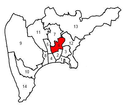
Ницца (arrondissement of Nice, arrondissement de Nice)

- округ Франции
 Hiking in Ницца
The Arrondissement of Nice, located in the Alpes-Maritimes department in southeastern France, offers a stunning variety of hiking trails that showcase the region's diverse landscapes, from coastal paths along the Mediterranean Sea to rugged mountain trails in the nearby Alps. Here are some highlights and popular hiking spots in the area:
1.
Located a bit inland from Nice, Mercantour National Park features breathtaking scenery, including alpine meadows, glacial valleys, and a rich variety of wildlife. The park has numerous well-marked trails, with options ranging from easy walks to challenging hikes.
2.
This scenic trail wraps around the Peninsula of Saint-Jean-Cap-Ferrat, offering spectacular views of the Mediterranean Sea, luxury villas, and beautiful flora. The walk is relatively easy and takes about 2-3 hours, making it great for family outings.
3.
A popular hike near the town of La Turbie, this trail leads to the Tête de Chien summit, which offers panoramic views of Monaco, the French Riviera, and the surrounding mountains. The hike is moderately challenging and is about 4-5 hours round trip.
4.
This is a picturesque trail connecting the medieval village of Eze to the coastal town of Eze-sur-Mer. You will experience stunning views, charming streets, and a chance to explore the village's botanical garden and exotic plants.
5.
While not a traditional hiking trail, walking along the Promenade des Anglais is a pleasant way to enjoy the coastal scenery of Nice. It’s an ideal location for leisurely strolls and runs along the famous beachside walkway.
6.
For those looking for a hiking experience coupled with some history, this trail leads to an observatory with excellent views of the city and coastline. The hike is moderately difficult and takes about 2-3 hours.
Tips for Hiking in the Arrondissement of Nice:
- Seasonal Considerations: Spring and autumn are generally the best times for hiking, as summers can be quite hot, especially along coastal trails.
- Preparation: Always check the weather and trail conditions before heading out. Bring enough water, snacks, and wear appropriate hiking shoes.
- Safety: Some trails can be steep or remote. Ensure someone is aware of your hiking plans and times.
- Respect Nature: Follow Leave No Trace principles to preserve the natural beauty of the area.
Whether you're a seasoned hiker or a casual walker, the Arrondissement of Nice has something to offer everyone seeking to explore the great outdoors!
- Страна:

- Столица: Ницца
- Координаты: 44° 0' 0" N, 7° 15' 0" E


- GPS треки (wikiloc): [Ссылка]
- Площадь: 3067 кв.км
- Население: 521676
- Википедия русская: wiki(ru)
- Википедия английская: wiki(en)
- Википедия национальная: wiki(fr)
- Хранилище Wikidata: Wikidata: Q701950
- код Freebase: [/m/095kjd]
- код GeoNames: Альт: [2990439]
- код округа INSEE: [062]
- код GNS: -1454991
Включает регионы:

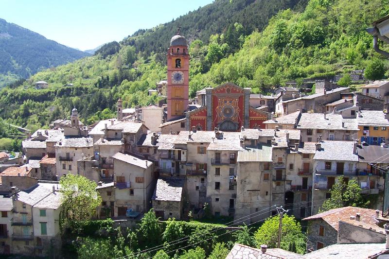
Виллар-сюр-Вар
Hiking in Виллар-сюр-Вар
Canton de Villars-sur-Var, located in the Alpes-Maritimes region of France, offers a variety of hiking opportunities that cater to different skill levels and preferences. With its stunning landscapes, picturesque villages, and diverse flora and fauna, it's a fantastic destination for outdoor enthusiasts....
- Страна:
- Столица: Виллар-сюр-Вар
- Координаты: 43° 56' 17" N, 7° 5' 52" E
- GPS треки (wikiloc): [Ссылка]


Ницца-5
- Страна:
- Столица: Ницца
- Координаты: 43° 42' 10" N, 7° 16' 9" E
- GPS треки (wikiloc): [Ссылка]
- Население: 46288

Ницца-2
- Страна:
- Столица: Ницца
- Координаты: 43° 42' 10" N, 7° 16' 9" E
- GPS треки (wikiloc): [Ссылка]
- Население: 46730


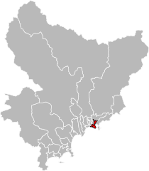
Босолей (кантон)
- кантон Франции
- Страна:
- Столица: Босолей
- Координаты: 43° 44' 33" N, 7° 25' 28" E
- GPS треки (wikiloc): [Ссылка]
- Население: 34262


Конт (кантон)
Hiking in Конт (кантон)
The Canton of Contes, located in the picturesque region of the French Riviera in southeastern France, offers a variety of hiking opportunities for nature lovers and outdoor enthusiasts. Here are some highlights and tips for hiking in this area:...
- Страна:
- Столица: Конт
- Координаты: 43° 48' 46" N, 7° 18' 52" E
- GPS треки (wikiloc): [Ссылка]
- Население: 36532

Гийом (кантон)
Hiking in Гийом (кантон)
Canton de Guillaumes is a beautiful area in the French Alps, known for its stunning landscapes, charming villages, and diverse hiking opportunities. Here are some highlights for hiking in this region:...


Ницца-1
- Страна:
- Столица: Ницца
- Координаты: 43° 42' 10" N, 7° 16' 9" E
- GPS треки (wikiloc): [Ссылка]
- Население: 45017

Ницца-3
- Страна:
- Столица: Ницца
- Координаты: 43° 42' 10" N, 7° 16' 9" E
- GPS треки (wikiloc): [Ссылка]
- Население: 40441

Ницца-7
- Страна:
- Столица: Ницца
- Координаты: 43° 42' 10" N, 7° 16' 9" E
- GPS треки (wikiloc): [Ссылка]
- Население: 38684

Ницца-8
- Страна:
- Столица: Ницца
- Координаты: 43° 42' 10" N, 7° 16' 9" E
- GPS треки (wikiloc): [Ссылка]
- Население: 38619

Сен-Совёр-сюр-Тине (кантон)
Hiking in Сен-Совёр-сюр-Тине (кантон)
Canton de Saint-Sauveur-sur-Tinée, located in the Alpes-Maritimes department of the French Alps, offers a beautiful backdrop for hiking enthusiasts. The region is characterized by its stunning mountainous landscapes, rolling hills, and picturesque villages, providing various trails suitable for all levels of hikers....
- Страна:
- Столица: Сен-Совёр-сюр-Тине
- Координаты: 44° 5' 5" N, 7° 6' 20" E
- GPS треки (wikiloc): [Ссылка]
- Площадь: 312.10 кв.км
- Население: 2362
Танд (кантон)
Hiking in Танд (кантон)
Canton de Tende, located in the Alpes-Maritimes department of France, is a beautiful hiking destination characterized by its stunning natural landscapes, rich biodiversity, and historical sites. Here are some key points to consider when hiking in Canton de Tende:...

Сен-Мартен-Везюби
Hiking in Сен-Мартен-Везюби
Canton de Saint-Martin-Vésubie, located in the Alpes-Maritimes region of France, offers a stunning hiking experience amidst the beautiful backdrop of the French Alps. Here are some key points to consider when exploring this area:...
- Страна:
- Столица: Сен-Мартен-Везюби
- Координаты: 44° 4' 9" N, 7° 15' 24" E
- GPS треки (wikiloc): [Ссылка]

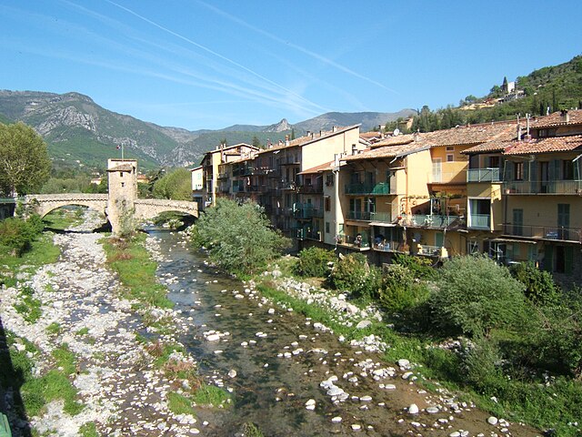
Вильфранш-сюр-Мер
- кантон Франции
- Страна:
- Столица: Вильфранш-сюр-Мер
- Координаты: 43° 42' 18" N, 7° 18' 45" E
- GPS треки (wikiloc): [Ссылка]

Леван
- кантон - метрополия Франции, Прованс — Альпы — Лазурный Берег, Приморские Альпы, Ницца
Hiking in Леван
Canton de Levens, located near Nice in the Alpes-Maritimes region of France, offers a variety of hiking opportunities with stunning landscapes, charming villages, and a mix of natural and cultural attractions. The area is characterized by rolling hills, forests, and views of the surrounding mountains and valleys....

Пюже-Тенье
Hiking in Пюже-Тенье
Canton de Puget-Théniers, located in the Alpes-Maritimes department of southeastern France, offers a variety of hiking opportunities characterized by stunning natural landscapes, diverse ecosystems, and charming villages. Here’s what you can expect when hiking in this area:...
- Страна:
- Столица: Пюже-Тенье
- Координаты: 43° 57' 25" N, 6° 53' 39" E
- GPS треки (wikiloc): [Ссылка]

Брей-сюр-Руайя
Hiking in Брей-сюр-Руайя
Canton de Breil-sur-Roya, located in the Alpes-Maritimes department in southeastern France, offers stunning natural landscapes that are perfect for hiking enthusiasts. This region is characterized by its rugged terrain, picturesque valleys, and charming villages. Here are some highlights and tips for hiking in this area:...
- Страна:
- Столица: Брей-сюр-Руайя
- Координаты: 43° 56' 17" N, 7° 30' 54" E
- GPS треки (wikiloc): [Ссылка]
Ницца-9
- Страна:
- Столица: Ницца
- Координаты: 43° 42' 10" N, 7° 16' 9" E
- GPS треки (wikiloc): [Ссылка]
- Население: 34594

Сент-Этьен-де-Тине
Hiking in Сент-Этьен-де-Тине
Canton de Saint-Étienne-de-Tinée is a stunning destination located in the Alpes-Maritimes department of France. It's a fantastic place for hiking enthusiasts, offering a variety of trails that cater to different skill levels and preferences. Here are some highlights and notable trails in the region:...
- Страна:
- Столица: Сент-Этьен-де-Тине
- Координаты: 44° 15' 28" N, 6° 55' 31" E
- GPS треки (wikiloc): [Ссылка]
- Площадь: 352.82 кв.км
- Население: 2082

Лантоск
Hiking in Лантоск
Canton de Lantosque, located in the Alpes-Maritimes department in southeastern France, is known for its stunning natural landscapes, diverse flora and fauna, and rugged mountain terrain. This area is part of the Mercantour National Park, which offers numerous hiking opportunities for all levels of experience....
Соспель
Hiking in Соспель
Canton de Sospel, located in the Alpes-Maritimes department of southeastern France, is a fantastic area for hiking enthusiasts. Nestled in the foothills of the Alps and close to the Italian border, it boasts stunning scenery, rich biodiversity, and a variety of trails suitable for different skill levels....

Рокбийьер
Hiking in Рокбийьер
Canton de Roquebillière is a beautiful region nestled in the French Alps, specifically in the Alpes-Maritimes department. It offers a range of hiking opportunities for adventurers and nature lovers alike. Here are some highlights and tips for hiking in this area:...

Рокестерон
Hiking in Рокестерон
Canton de Roquestéron is a beautiful area located in the Alpes-Maritimes department of France, known for its stunning natural landscapes, charming villages, and outdoor recreational opportunities. Here’s an overview of what you can expect when hiking in this region:...
- Страна:
- Столица: Рокестерон
- Координаты: 43° 52' 29" N, 7° 0' 19" E
- GPS треки (wikiloc): [Ссылка]

Л’Эскарен
- кантон Франции
Hiking in Л’Эскарен
Canton de L'Escarène, located in the Alpes-Maritimes department in the Provence-Alpes-Côte d'Azur region of France, offers a fantastic setting for hiking enthusiasts. The area is characterized by its stunning landscapes, which include rolling hills, forested areas, and a blend of rivers and rocky terrains, providing a variety of trails suitable for different skill levels....