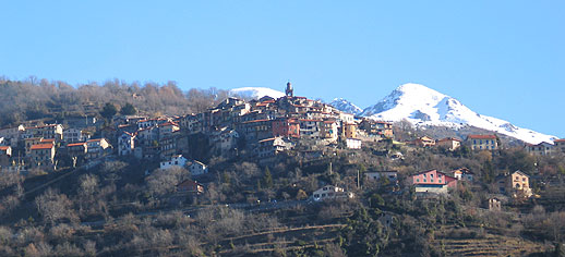
Тенд (Tende, Tende)

- коммуна в департаменте Приморские Альпы, регион Прованс — Альпы — Лазурный Берег, Франция
 Hiking in Тенд
Tende is a picturesque commune located in the Alpes-Maritimes department in the Provence-Alpes-Côte d'Azur region of southeastern France. Nestled in the Maritime Alps, it's an excellent destination for hiking enthusiasts, offering stunning landscapes, varied terrains, and rich natural and cultural heritage.
Hiking Trails in Tende
-
Vallee de la Roya: The area around Tende is famous for its breathtaking valleys. The Roya Valley offers numerous trails with varying difficulty levels, allowing hikers to explore both easy walks and challenging treks.
-
Sentier des Merveilles: This is one of the most famous trails in the area, leading to the archaeological site of the rock engravings in the Vallée des Merveilles. The hike offers unique landscapes, including granite rock formations and vibrant alpine meadows.
-
Col de Tende to Limone Piemonte: This trail connects Tende to the Italian side of the mountains. It features stunning panoramic views and is suitable for those looking for an international hiking experience.
-
Mont Bégo: This iconic peak is an excellent hiking destination for experienced trekkers. The trail to Mont Bégo offers challenging sections but rewards hikers with spectacular views and the chance to see ancient rock carvings.
-
Ecopark of the Vallée des Merveilles: This area combines hiking with environmental education. There are well-marked trails that allow hikers to observe the local flora and fauna and learn about the region's biodiversity.
Best Time to Hike
The best time for hiking in Tende is typically from late spring (May) to early autumn (September). During these months, the weather is generally pleasant, and the trails are accessible. Be mindful of potential snow at higher elevations in early spring and late autumn.
Important Tips
- Preparation: Always prepare thoroughly before a hike. Check the weather, wear appropriate clothing, and carry enough water and snacks.
- Trail Maps: Familiarize yourself with local trail maps and consider using a GPS app for navigation.
- Leave No Trace: Respect the environment by following Leave No Trace principles. Keep the area clean and respect wildlife.
- Safety: Always inform someone about your hiking plans, especially if hiking alone or on less-traveled paths.
Tende's rich natural beauty and diverse hiking opportunities make it an excellent destination for both novice and experienced hikers. Enjoy the adventure and the stunning scenery!
- Страна:

- Почтовый код: 06430
- Координаты: 44° 5' 16" N, 7° 35' 37" E


- GPS треки (wikiloc): [Ссылка]
- Высота над уровнем моря: 816 м m
- Площадь: 177.47 кв.км
- Население: 2174
- Веб сайт: http://www.tende.fr/
- Википедия русская: wiki(ru)
- Википедия английская: wiki(en)
- Википедия национальная: wiki(fr)
- Хранилище Wikidata: Wikidata: Q236609
- Галерея изображений в википедии: [Ссылка]
- Катеория в википедии: [Ссылка]
- код Freebase: [/m/0dt3td]
- код Freebase: [/m/0dt3td]
- код GeoNames: Альт: [6453571]
- код GeoNames: Альт: [6453571]
- номер SIREN: [210601639]
- номер SIREN: [210601639]
- WOEID: [22756271]
- WOEID: [22756271]
- код муниципалитета INSEE: 06163
- код муниципалитета INSEE: 06163
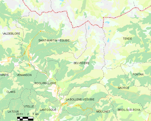
Граничит с регионами:

Брига-Альта
- коммуна Италии
Hiking in Брига-Альта
Briga Alta is a charming town located in the Piedmont region of northern Italy, known for its beautiful landscapes, historical significance, and excellent hiking opportunities. If you're considering hiking in that area, here are some details to keep in mind:...
- Страна:

- Почтовый код: 18025
- Телефонный код: 0174
- Код автомобильного номера: CN
- Координаты: 44° 4' 53" N, 7° 44' 27" E
- GPS треки (wikiloc): [Ссылка]
- Высота над уровнем моря: 1310 м m
- Площадь: 52.18 кв.км
- Население: 40
- Веб сайт: [Ссылка]

Лимоне-Пьемонте
- коммуна Италии
Hiking in Лимоне-Пьемонте
Limone Piemonte is a charming alpine resort located in the Piedmont region of Italy, nestled in the Maritime Alps, near the border with France. It offers a range of hiking opportunities that cater to different skill levels, from casual walks to more challenging treks. Here are some key highlights about hiking in Limone Piemonte:...
- Страна:
- Почтовый код: 12015
- Телефонный код: 0171
- Код автомобильного номера: CN
- Координаты: 44° 12' 0" N, 7° 34' 0" E
- GPS треки (wikiloc): [Ссылка]
- Высота над уровнем моря: 1010 м m
- Площадь: 70.81 кв.км
- Население: 1466
- Веб сайт: [Ссылка]


Ла-Бриг
- коммуна в департаменте Приморские Альпы, регион Прованс — Альпы — Лазурный Берег, Франция
Hiking in Ла-Бриг
La Brigue is a beautiful commune in the Alpes-Maritimes department of southeastern France, located near the Italian border. Nestled in the Mercantour National Park, it offers stunning landscapes, diverse flora and fauna, and various hiking trails suitable for all levels of hikers. Here are some highlights about hiking in La Brigue:...
- Страна:
- Почтовый код: 06430
- Координаты: 44° 3' 45" N, 7° 36' 59" E
- GPS треки (wikiloc): [Ссылка]
- Высота над уровнем моря: 748 м m
- Площадь: 91.77 кв.км
- Население: 706
- Веб сайт: [Ссылка]
Бельведер
- коммуна в департаменте Приморские Альпы, регион Прованс — Альпы — Лазурный Берег, Франция
Hiking in Бельведер
Belvédère is a beautiful hiking destination that is often characterized by stunning views and diverse landscapes. Although the specifics can depend on which "Belvédère" you are referring to, as the name can be found in different locations around the world, I'll provide an overview of what you typically might expect when hiking in areas known by this name....
- Страна:
- Почтовый код: 06450
- Координаты: 44° 0' 53" N, 7° 19' 16" E
- GPS треки (wikiloc): [Ссылка]
- Площадь: 75.41 кв.км
- Население: 660


Фонтан
- коммуна в департаменте Приморские Альпы, регион Прованс — Альпы — Лазурный Берег, Франция
Hiking in Фонтан
Fontan is a small village located in the Alpes-Maritimes department in southeastern France. Nestled in the mountains, it offers a variety of scenic hiking opportunities for outdoor enthusiasts. Here are some highlights and tips for hiking in and around Fontan:...
- Страна:
- Почтовый код: 06540
- Координаты: 44° 0' 14" N, 7° 33' 13" E
- GPS треки (wikiloc): [Ссылка]
- Площадь: 49.61 кв.км
- Население: 352
- Веб сайт: [Ссылка]

Саорж
- коммуна в департаменте Приморские Альпы, регион Прованс — Альпы — Лазурный Берег, Франция
Hiking in Саорж
Saorge is a picturesque village located in the Alpes-Maritimes region of France, not far from the Italian border. The area is known for its stunning landscapes, charming architecture, and an array of hiking opportunities that cater to different skill levels. Here are some highlights and trails to consider when hiking in and around Saorge:...
- Страна:
- Почтовый код: 06540
- Координаты: 43° 59' 14" N, 7° 33' 9" E
- GPS треки (wikiloc): [Ссылка]
- Высота над уровнем моря: 513 м m
- Площадь: 86.78 кв.км
- Население: 455
- Веб сайт: [Ссылка]