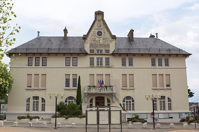
Бокруассан (Beaucroissant, Beaucroissant)

- коммуна во Франции
 Hiking in Бокруассан
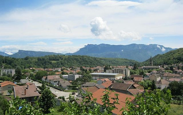
Beaucroissant, located in the Isère department in the Auvergne-Rhône-Alpes region of France, offers a charming setting for hiking enthusiasts. The area is characterized by beautiful landscapes, rolling hills, and proximity to the Alps, making it a great base for exploring both gentle and more challenging trails.
Hiking Options:
-
Local Trails:
- Beaucroissant has several marked trails that range from easy to moderate difficulty. These trails often meander through picturesque countryside, fields, and forests, providing a peaceful environment for hikers.
- Look for local hiking maps or guides, often available from the town office or local tourism centers, to help you navigate the best routes.
-
Domaine de la Grande Chartreuse:
- A bit further from Beaucroissant, this region includes trails that lead up to the Grande Chartreuse monastery and the surrounding natural park. Here you'll find more strenuous hikes with rewarding views of the landscape below.
-
Chartreuse Regional Park:
- Just a short drive away, this park offers numerous hiking paths with varying difficulty levels. You can enjoy dramatic cliffs, lush forests, and scenic viewpoints. Trails such as the GR9 (the Grande Randonnée trail) can be explored in this area.
Considerations for Hiking:
-
Seasonal Factors: Spring and autumn are generally ideal for hiking, providing mild temperatures and beautiful foliage. Winter hikes can be stunning too, but check on snow conditions before heading out.
-
Equipment: Wear sturdy hiking boots and dress in layers, as temperatures can change quickly. Bring enough water, snacks, and a map or GPS device.
-
Local Guides: If you're unfamiliar with the area or prefer guided experiences, consider hiring a local guide who can offer insight into both the trails and the local culture.
Conclusion:
Hiking in Beaucroissant can be a delightful experience, combining natural beauty with the rich culture of the French Alps. Make sure to plan your hike according to your fitness level and interest, and always respect the natural environment while enjoying the outdoors.
- Страна:

- Почтовый код: 38140
- Координаты: 45° 20' 26" N, 5° 28' 13" E


- GPS треки (wikiloc): [Ссылка]
- Площадь: 11.18 кв.км
- Население: 1621
- Веб сайт: http://www.beaucroissant.com
- Википедия русская: wiki(ru)
- Википедия английская: wiki(en)
- Википедия национальная: wiki(fr)
- Хранилище Wikidata: Wikidata: Q468213
- Катеория в википедии: [Ссылка]
- код Freebase: [/m/03g_75b]
- код GeoNames: Альт: [6448723]
- номер SIREN: [213800303]
- код BNF: [15257859s]
- код VIAF: Альт: [146721544]
- код муниципалитета INSEE: 38030
Граничит с регионами:

Рив
Hiking in Рив
Rives, located in the Isère department of the Auvergne-Rhône-Alpes region in southeastern France, offers a range of outdoor activities, including hiking. The area is characterized by its picturesque landscapes, mountainous terrain, and proximity to the French Alps, making it a great starting point for various hiking adventures....
- Страна:
- Почтовый код: 38140
- Координаты: 45° 21' 3" N, 5° 30' 8" E
- GPS треки (wikiloc): [Ссылка]
- Площадь: 10.93 кв.км
- Население: 6242
- Веб сайт: [Ссылка]


Сен-Поль-д'Изо
- коммуна во Франции
Hiking in Сен-Поль-д'Изо
Saint-Paul-d'Izeaux is a charming commune located in the Isère department of the Auvergne-Rhône-Alpes region in southeastern France. It’s a fantastic destination for hiking enthusiasts looking for beautiful landscapes and a mix of natural beauty and cultural sites....
- Страна:
- Почтовый код: 38140
- Координаты: 45° 19' 0" N, 5° 25' 46" E
- GPS треки (wikiloc): [Ссылка]
- Площадь: 7.63 кв.км
- Население: 296

Ренаж
- коммуна во Франции
Hiking in Ренаж
Renage is a picturesque village located in the Isère department in the Auvergne-Rhône-Alpes region of southeastern France. Surrounded by stunning natural landscapes, it's an excellent base for various hiking adventures....
- Страна:
- Почтовый код: 38140
- Координаты: 45° 20' 0" N, 5° 29' 7" E
- GPS треки (wikiloc): [Ссылка]
- Площадь: 5.1 кв.км
- Население: 3557
- Веб сайт: [Ссылка]


Тюллен
- коммуна во Франции
Hiking in Тюллен
Tullins is a charming town located in the Isère department of the Auvergne-Rhône-Alpes region in southeastern France. It's ideally situated near the French Alps, offering access to a range of hiking opportunities that cater to various skill levels....
- Страна:
- Почтовый код: 38210
- Координаты: 45° 17' 51" N, 5° 29' 0" E
- GPS треки (wikiloc): [Ссылка]
- Площадь: 28.79 кв.км
- Население: 7655
- Веб сайт: [Ссылка]


Изо
Hiking in Изо
Izeaux is a small commune located in the Isère department in the Auvergne-Rhône-Alpes region of southeastern France. Nestled in the foothills of the Alps, it offers a variety of hiking opportunities for both beginners and experienced hikers....
- Страна:
- Почтовый код: 38140
- Координаты: 45° 20' 4" N, 5° 25' 27" E
- GPS треки (wikiloc): [Ссылка]
- Площадь: 15.54 кв.км
- Население: 2154
- Веб сайт: [Ссылка]


Коломб
Hiking in Коломб
Colombe is a region that typically offers a variety of hiking opportunities depending on its geographical features and local trails. Since I don’t have specific details about Colombe, I can offer some general advice for hiking in areas that might be similar:...
- Страна:
- Почтовый код: 38690
- Координаты: 45° 23' 56" N, 5° 26' 58" E
- GPS треки (wikiloc): [Ссылка]
- Площадь: 13.23 кв.км
- Население: 1506
- Веб сайт: [Ссылка]