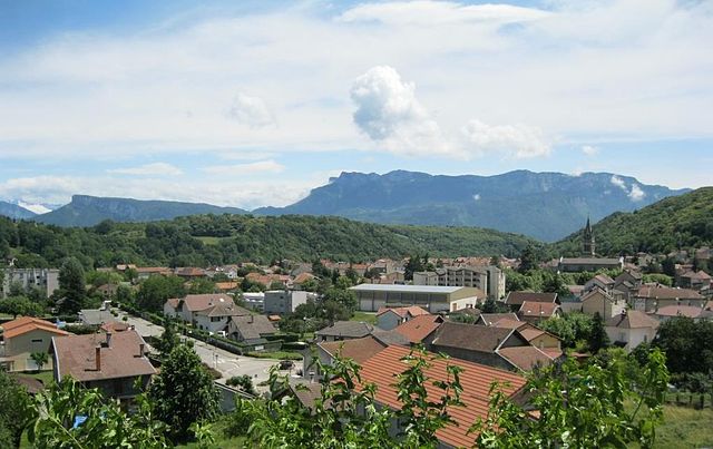
Тюллен (Tullins, Tullins)

- коммуна во Франции
 Hiking in Тюллен
Tullins is a charming town located in the Isère department of the Auvergne-Rhône-Alpes region in southeastern France. It's ideally situated near the French Alps, offering access to a range of hiking opportunities that cater to various skill levels.
Hiking Trails in and around Tullins
-
Col de la Placette: This is a popular starting point for several hiking trails. The route to the col offers stunning views of the surrounding mountains and is suitable for intermediate hikers.
-
Mont Aiguille: A bit further afield, Mont Aiguille is a striking peak that offers challenging hikes with rewarding vistas. The trails here can be strenuous but are well worth the effort for experienced hikers.
-
The Vercors Regional Natural Park: Just to the east of Tullins, this park is a hiker’s paradise with diverse landscapes, from limestone cliffs to lush forests. There are numerous marked trails for different skill levels. The park is also home to wildlife, including deer and various bird species.
-
Isère River Trails: For a more leisurely stroll, you can hike along the Isère River, where you’ll find flat and well-marked paths that are great for families or those looking for a gentle walk.
Tips for Hiking in Tullins
-
Best Time to Hike: Spring and autumn are ideal for hiking to enjoy mild weather and beautiful scenery. Summer can be warm, while winter offers snow activities if you enjoy winter hiking.
-
Safety First: Always check the weather forecast before heading out and ensure you have appropriate gear. Carry enough water, snacks, and a map or GPS device.
-
Local Regulations: Be aware of any local regulations or guidelines, especially in protected areas like the Vercors Regional Natural Park.
-
Guided Tours: If you’re unfamiliar with the area, consider joining a guided hike. Local guides can provide insights into the flora, fauna, and history of the region.
Additional Activities
Besides hiking, Tullins offers cycling opportunities and the chance to explore local culture through its markets, cafes, and historical sites. Make sure to take some time to enjoy the local cuisine after a day on the trails!
In conclusion, Tullins is an excellent base for outdoor enthusiasts looking to explore the beauty of the French Alps and surrounding nature. Whether you're a seasoned hiker or a beginner, there's something for everyone. Happy hiking!
- Страна:

- Почтовый код: 38210
- Координаты: 45° 17' 51" N, 5° 29' 0" E


- GPS треки (wikiloc): [Ссылка]
- Площадь: 28.79 кв.км
- Население: 7655
- Веб сайт: http://www.ville-tullins.fr
- Википедия русская: wiki(ru)
- Википедия английская: wiki(en)
- Википедия национальная: wiki(fr)
- Хранилище Wikidata: Wikidata: Q470740
- Катеория в википедии: [Ссылка]
- код Freebase: [/m/03nvjp_]
- код GeoNames: Альт: [2971480]
- номер SIREN: [213805179]
- код BNF: [15258317q]
- код VIAF: Альт: [153731389]
- код LCNAF: Альт: [n89627487]
- код муниципалитета INSEE: 38517
Граничит с регионами:


Вуре
- коммуна во Франции
Hiking in Вуре
Vourey is a charming village located in the Auvergne-Rhône-Alpes region of France, surrounded by picturesque landscapes ideal for hiking enthusiasts. The area offers a variety of trails that cater to different skill levels, from easy walks through scenic meadows to more challenging hikes that lead into the nearby hills and forests....
- Страна:
- Почтовый код: 38210
- Координаты: 45° 19' 15" N, 5° 31' 12" E
- GPS треки (wikiloc): [Ссылка]
- Площадь: 6.88 кв.км
- Население: 1711
- Веб сайт: [Ссылка]


Сен-Поль-д'Изо
- коммуна во Франции
Hiking in Сен-Поль-д'Изо
Saint-Paul-d'Izeaux is a charming commune located in the Isère department of the Auvergne-Rhône-Alpes region in southeastern France. It’s a fantastic destination for hiking enthusiasts looking for beautiful landscapes and a mix of natural beauty and cultural sites....
- Страна:
- Почтовый код: 38140
- Координаты: 45° 19' 0" N, 5° 25' 46" E
- GPS треки (wikiloc): [Ссылка]
- Площадь: 7.63 кв.км
- Население: 296


Сен-Кантен-сюр-Изер
- коммуна во Франции
Hiking in Сен-Кантен-сюр-Изер
Saint-Quentin-sur-Isère, located in the Isère department of France, is surrounded by beautiful landscapes that are perfect for hiking enthusiasts. The region features a mix of rolling hills, forests, and views of the nearby Alps, making it a great destination for hiking....
- Страна:
- Почтовый код: 38210
- Координаты: 45° 16' 45" N, 5° 32' 32" E
- GPS треки (wikiloc): [Ссылка]
- Площадь: 19.45 кв.км
- Население: 1396
- Веб сайт: [Ссылка]


Морет
- коммуна во Франции
Hiking in Морет
Morette, a charming village located in the French Alps, offers a variety of hiking opportunities that cater to different skill levels and preferences. Here are some key points to consider when planning a hike in Morette:...
- Страна:
- Почтовый код: 38210
- Координаты: 45° 17' 8" N, 5° 27' 7" E
- GPS треки (wikiloc): [Ссылка]
- Площадь: 6.27 кв.км
- Население: 415

Ренаж
- коммуна во Франции
Hiking in Ренаж
Renage is a picturesque village located in the Isère department in the Auvergne-Rhône-Alpes region of southeastern France. Surrounded by stunning natural landscapes, it's an excellent base for various hiking adventures....
- Страна:
- Почтовый код: 38140
- Координаты: 45° 20' 0" N, 5° 29' 7" E
- GPS треки (wikiloc): [Ссылка]
- Площадь: 5.1 кв.км
- Население: 3557
- Веб сайт: [Ссылка]


Бокруассан
- коммуна во Франции
Hiking in Бокруассан
Beaucroissant, located in the Isère department in the Auvergne-Rhône-Alpes region of France, offers a charming setting for hiking enthusiasts. The area is characterized by beautiful landscapes, rolling hills, and proximity to the Alps, making it a great base for exploring both gentle and more challenging trails....
- Страна:
- Почтовый код: 38140
- Координаты: 45° 20' 26" N, 5° 28' 13" E
- GPS треки (wikiloc): [Ссылка]
- Площадь: 11.18 кв.км
- Население: 1621
- Веб сайт: [Ссылка]
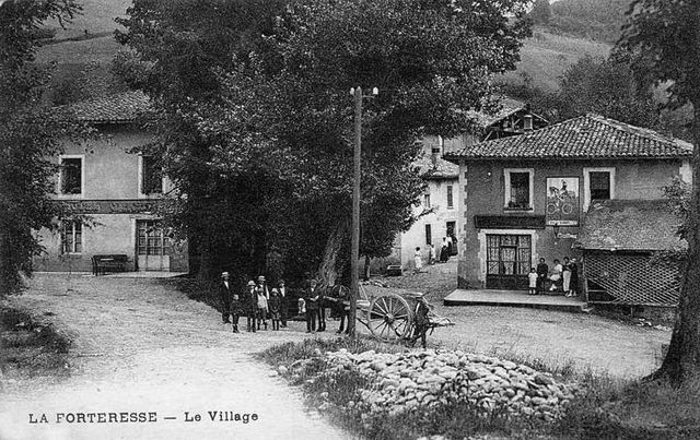
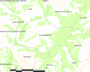
Ла-Фортрес
- коммуна во Франции
Hiking in Ла-Фортрес
La Forteresse, located in the Vosges Mountains of northeastern France, is a popular destination for hiking enthusiasts. The area is known for its stunning natural beauty, rich history, and diverse trails that cater to various skill levels. Here are some key points to consider when hiking in La Forteresse:...
- Страна:
- Почтовый код: 38590
- Координаты: 45° 17' 41" N, 5° 24' 13" E
- GPS треки (wikiloc): [Ссылка]
- Площадь: 9.22 кв.км
- Население: 324

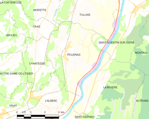
Польенас
- коммуна во Франции
Hiking in Польенас
Poliénas, a charming commune in the Isère department of southeastern France, is well situated for outdoor activities, including hiking. Nestled near the foothills of the Alps, the area offers stunning natural landscapes, diverse terrain, and numerous trails suitable for various skill levels....
- Страна:
- Почтовый код: 38210
- Координаты: 45° 14' 56" N, 5° 28' 17" E
- GPS треки (wikiloc): [Ссылка]
- Площадь: 14.03 кв.км
- Население: 1150
- Веб сайт: [Ссылка]