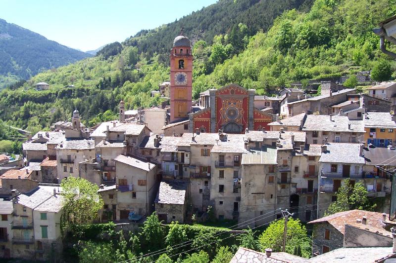
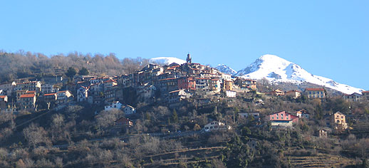
Саорж (Saorge, Saorge)

- коммуна в департаменте Приморские Альпы, регион Прованс — Альпы — Лазурный Берег, Франция
 Hiking in Саорж
Saorge is a picturesque village located in the Alpes-Maritimes region of France, not far from the Italian border. The area is known for its stunning landscapes, charming architecture, and an array of hiking opportunities that cater to different skill levels. Here are some highlights and trails to consider when hiking in and around Saorge:
Key Features of Hiking in Saorge:
-
Scenic Views: The trails often provide breathtaking views of the Roya Valley and the surrounding mountains. Expect to see lush vegetation, rugged cliffs, and the serene presence of the river below.
-
Diverse Trails: There are several hiking trails with varying difficulties, from easy walks suitable for families to more challenging routes that require a good level of fitness.
-
Historical Visits: Along many trails, you can encounter historical sites, including ancient ruins and the charming architecture of the village itself, including the stunning Baroque church.
-
Natural Features: The area is rich in biodiversity. You may spot various flora and fauna along the trails, particularly in the spring and early summer when wildflowers are in bloom.
-
Mild Climate: The climate in Saorge is typically mild, making it a year-round hiking destination, although the best times are during the spring and fall when the weather is pleasant, and the trails are less crowded.
Popular Hiking Trails Near Saorge:
-
Sentier de Saorge: This is a local circular hike that leads you around the village, giving you views of the architecture and the surrounding landscape. It's an excellent choice for a short, leisurely outing.
-
Les Balcons de la Roya: This trail offers stunning viewpoints over the Roya Valley and is perfect for those seeking photo opportunities. The trail's moderate difficulty level makes it accessible for most hikers.
-
Sentier de la Source: A beautiful trail that leads to a natural spring, it’s a great option for those looking for a peaceful hike through nature.
-
Tende to Saorge Trail: For more experienced hikers, this trail connects the nearby town of Tende to Saorge and features more mountainous terrain along with breathtaking views.
-
Civrieux Trail: This is another option for those looking to explore more of the natural parks surrounding Saorge with various elevations and diverse landscapes.
Safety and Preparation:
-
Maps and Guides: Always carry a reliable map or guidebook of the area as trails can sometimes be poorly marked.
-
Weather Considerations: Check weather conditions before heading out and be prepared for changes in weather, especially in the mountains.
-
Hydration and Nutrition: Bring plenty of water and snacks, especially for longer hikes.
-
Footwear: Wear sturdy hiking boots for better grip and protection against uneven terrain.
Conclusion: Hiking in Saorge offers a combination of natural beauty, rich history, and a sense of adventure, making it an excellent destination for both novice and experienced hikers. Whether you're looking for a casual stroll or a more rigorous trek, Saorge's trails will not disappoint. Happy hiking!
- Страна:

- Почтовый код: 06540
- Координаты: 43° 59' 14" N, 7° 33' 9" E


- GPS треки (wikiloc): [Ссылка]
- Высота над уровнем моря: 513 м m
- Площадь: 86.78 кв.км
- Население: 455
- Веб сайт: http://www.saorge.fr
- Википедия русская: wiki(ru)
- Википедия английская: wiki(en)
- Википедия национальная: wiki(fr)
- Хранилище Wikidata: Wikidata: Q965394
- Галерея изображений в википедии: [Ссылка]
- Катеория в википедии: [Ссылка]
- код Freebase: [/m/03m4_0d]
- код Freebase: [/m/03m4_0d]
- код GeoNames: Альт: [2976080]
- код GeoNames: Альт: [2976080]
- номер SIREN: [210601324]
- номер SIREN: [210601324]
- код BNF: [13740244s]
- код BNF: [13740244s]
- код VIAF: Альт: [246964071]
- код VIAF: Альт: [246964071]
- код муниципалитета INSEE: 06132
- код муниципалитета INSEE: 06132
Граничит с регионами:

Тенд
- коммуна в департаменте Приморские Альпы, регион Прованс — Альпы — Лазурный Берег, Франция
Hiking in Тенд
Tende is a picturesque commune located in the Alpes-Maritimes department in the Provence-Alpes-Côte d'Azur region of southeastern France. Nestled in the Maritime Alps, it's an excellent destination for hiking enthusiasts, offering stunning landscapes, varied terrains, and rich natural and cultural heritage....
- Страна:
- Почтовый код: 06430
- Координаты: 44° 5' 16" N, 7° 35' 37" E
- GPS треки (wikiloc): [Ссылка]
- Высота над уровнем моря: 816 м m
- Площадь: 177.47 кв.км
- Население: 2174
- Веб сайт: [Ссылка]


Пинья
- коммуна Италии
Hiking in Пинья
Pigna, a picturesque village in the Italian region of Liguria, offers a wonderful hiking experience characterized by its enchanting landscapes, olive groves, and stunning views of the surrounding mountains and valleys. Here are some key points to consider when planning a hiking trip to Pigna:...
- Страна:

- Почтовый код: 18037
- Телефонный код: 0184
- Код автомобильного номера: IM
- Координаты: 43° 55' 57" N, 7° 39' 50" E
- GPS треки (wikiloc): [Ссылка]
- Высота над уровнем моря: 280 м m
- Площадь: 53.23 кв.км
- Население: 843
- Веб сайт: [Ссылка]


Роккетта-Нервина
- коммуна Италии
Hiking in Роккетта-Нервина
Rocchetta Nervina is a charming village located in the Liguria region of Italy, specifically in the Province of Imperia. Nestled in the Nervia Valley and surrounded by stunning mountainous terrain, it serves as an excellent base for hiking enthusiasts looking to explore the natural beauty of the area....
- Страна:
- Почтовый код: 18030
- Телефонный код: 0184
- Код автомобильного номера: IM
- Координаты: 43° 53' 24" N, 7° 36' 1" E
- GPS треки (wikiloc): [Ссылка]
- Высота над уровнем моря: 235 м m
- Площадь: 15.29 кв.км
- Население: 299
- Веб сайт: [Ссылка]


Триора
- коммуна Италии
Hiking in Триора
Triora is a picturesque village located in the Italian region of Liguria, known for its stunning landscapes and rich history. Nestled in the mountains, it's an excellent destination for hiking enthusiasts....
- Страна:
- Почтовый код: 18010
- Телефонный код: 0184
- Код автомобильного номера: IM
- Координаты: 44° 0' 0" N, 7° 46' 0" E
- GPS треки (wikiloc): [Ссылка]
- Высота над уровнем моря: 780 м m
- Площадь: 68 кв.км
- Население: 361
- Веб сайт: [Ссылка]


Брей-сюр-Руайя
- коммуна в департаменте Приморские Альпы, регион Прованс — Альпы — Лазурный Берег, Франция
Hiking in Брей-сюр-Руайя
Breil-sur-Roya, located in the Alpes-Maritimes department of France, is a charming village that serves as a gateway to some beautiful hiking trails in the surrounding area. Nestled in the Roya Valley, it offers a mix of stunning natural landscapes, historical sites, and a chance to experience the local culture....
- Страна:
- Почтовый код: 06540
- Координаты: 43° 56' 14" N, 7° 30' 52" E
- GPS треки (wikiloc): [Ссылка]
- Высота над уровнем моря: 287 м m
- Площадь: 81.31 кв.км
- Население: 2271
- Веб сайт: [Ссылка]


Ла-Боллен-Везюби
- коммуна в департаменте Приморские Альпы, регион Прованс — Альпы — Лазурный Берег, Франция
Hiking in Ла-Боллен-Везюби
La Bollène-Vésubie is a charming village located in the Alpes-Maritimes department in the Provence-Alpes-Côte d'Azur region of France. It offers access to beautiful hiking trails that showcase the stunning landscapes of the French Alps. Here are some highlights for hikers considering this area:...
- Страна:
- Почтовый код: 06450
- Координаты: 43° 59' 23" N, 7° 19' 51" E
- GPS треки (wikiloc): [Ссылка]
- Площадь: 35.57 кв.км
- Население: 567
- Веб сайт: [Ссылка]


Ла-Бриг
- коммуна в департаменте Приморские Альпы, регион Прованс — Альпы — Лазурный Берег, Франция
Hiking in Ла-Бриг
La Brigue is a beautiful commune in the Alpes-Maritimes department of southeastern France, located near the Italian border. Nestled in the Mercantour National Park, it offers stunning landscapes, diverse flora and fauna, and various hiking trails suitable for all levels of hikers. Here are some highlights about hiking in La Brigue:...
- Страна:
- Почтовый код: 06430
- Координаты: 44° 3' 45" N, 7° 36' 59" E
- GPS треки (wikiloc): [Ссылка]
- Высота над уровнем моря: 748 м m
- Площадь: 91.77 кв.км
- Население: 706
- Веб сайт: [Ссылка]
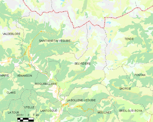
Бельведер
- коммуна в департаменте Приморские Альпы, регион Прованс — Альпы — Лазурный Берег, Франция
Hiking in Бельведер
Belvédère is a beautiful hiking destination that is often characterized by stunning views and diverse landscapes. Although the specifics can depend on which "Belvédère" you are referring to, as the name can be found in different locations around the world, I'll provide an overview of what you typically might expect when hiking in areas known by this name....
- Страна:
- Почтовый код: 06450
- Координаты: 44° 0' 53" N, 7° 19' 16" E
- GPS треки (wikiloc): [Ссылка]
- Площадь: 75.41 кв.км
- Население: 660


Фонтан
- коммуна в департаменте Приморские Альпы, регион Прованс — Альпы — Лазурный Берег, Франция
Hiking in Фонтан
Fontan is a small village located in the Alpes-Maritimes department in southeastern France. Nestled in the mountains, it offers a variety of scenic hiking opportunities for outdoor enthusiasts. Here are some highlights and tips for hiking in and around Fontan:...
- Страна:
- Почтовый код: 06540
- Координаты: 44° 0' 14" N, 7° 33' 13" E
- GPS треки (wikiloc): [Ссылка]
- Площадь: 49.61 кв.км
- Население: 352
- Веб сайт: [Ссылка]