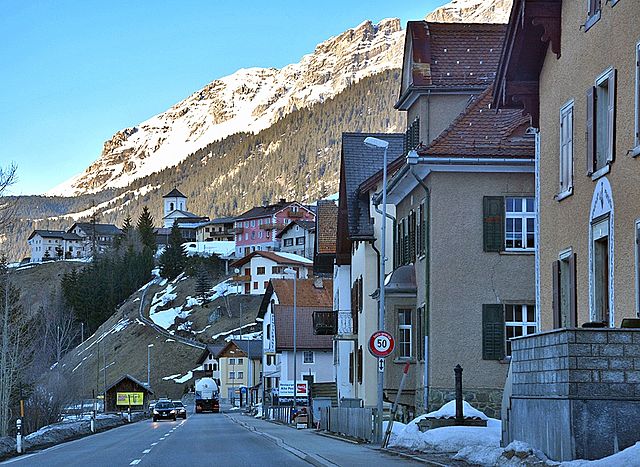
Бергюн (Bergün, Bergün/Bravuogn)

 Hiking in Бергюн
Bergün, located in the scenic Albula Valley in the Swiss canton of Graubünden, is a fantastic destination for hiking enthusiasts. The area offers a variety of trails that cater to different skill levels, making it suitable for families, casual hikers, and experienced trekkers alike. Here are some highlights of hiking in Bergün:
1.
- Albulatal Trail: This trail runs along the Albulatal and offers stunning views of the alpine landscapes, with lush forests, meadows, and breathtaking mountain vistas.
- Bergün to Preda: A popular hike that can be completed in about 2-3 hours, this route provides panoramic views and takes you through charming alpine pastures.
2.
Hiking in this region allows you to encounter diverse flora and fauna. Keep an eye out for local wildlife, including chamois and marmots, as well as a variety of wildflowers in the summer months.
3.
As you hike, you can also experience the rich culture of the region. Bergün is known for its traditional Engadine architecture and historical buildings. You might come across picturesque villages, churches, and even ancient Roman ruins along the trails.
4.
- Summer Hiking: Spring through autumn offers the best hiking conditions, with well-marked trails and the opportunity to enjoy wildflowers and clear blue skies.
- Winter Activities: In winter, Bergün transforms into a winter wonderland, and while traditional hiking is limited, snowshoeing and winter hiking trails are available, allowing for exploration of the snowy landscapes.
5.
Bergün is well-connected by public transport, making it easy to reach and explore various trailheads. You can also take advantage of local guides if you want to explore less-traveled paths or require specific knowledge about the area.
6.
As with any hiking expedition:
- Check the weather conditions before you head out.
- Bring suitable gear, including proper footwear, hiking poles, and plenty of water.
- It’s advisable to carry a map or download hiking apps that provide trail information and navigation.
In summary, Bergün offers a wealth of opportunities for hikers looking to explore stunning alpine landscapes, engaging in both leisurely walks and challenging hikes. Whether you're looking to connect with nature, enjoy the peace of the mountains, or immerse yourself in local culture, you'll find plenty to appreciate in this lovely Swiss destination.
- Страна:

- Почтовый код: 7482
- Телефонный код: 081
- Код автомобильного номера: GR
- Координаты: 46° 37' 26" N, 9° 47' 14" E


- GPS треки (wikiloc): [Ссылка]
- Высота над уровнем моря: 1367 м m
- Площадь: 145.65 кв.км
- Население: 480
- Веб сайт: http://www.berguen.ch
- Википедия русская: wiki(ru)
- Википедия английская: wiki(en)
- Википедия национальная: wiki(de)
- Хранилище Wikidata: Wikidata: Q68319
- Катеория в википедии: [Ссылка]
- код Freebase: [/m/0kw6gr]
- код GeoNames: Альт: [7285207]
- ID отношения в OpenStreetMap: [1684044]
- код GND: Альт: [4005700-8]
- идентификатор HDS: [1419]
- код швейцарского муниципалитета: [3521]
Граничит с регионами:


Ла-Пунт-Чамуэшч
Hiking in Ла-Пунт-Чамуэшч
La Punt-Chamues-ch is a picturesque village located in the Engadin valley of Switzerland, known for its stunning landscapes, traditional architecture, and excellent hiking opportunities. Here are some key aspects to consider when hiking in this beautiful region:...
- Страна:
- Почтовый код: 7522
- Телефонный код: 081
- Код автомобильного номера: GR
- Координаты: 46° 33' 59" N, 9° 54' 59" E
- GPS треки (wikiloc): [Ссылка]
- Высота над уровнем моря: 1687 м m
- Площадь: 63.27 кв.км
- Население: 712
- Веб сайт: [Ссылка]

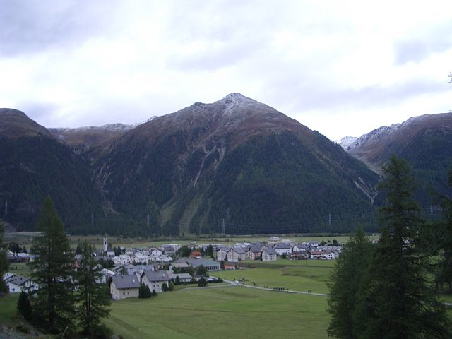
Тиницонг-Рона
Hiking in Тиницонг-Рона
Tinizong-Rona is a beautiful area located in the canton of Graubünden in Switzerland, known for its stunning landscapes and rich natural biodiversity. Hiking in this region offers a plethora of trails suitable for various skill levels, ranging from beginners to advanced hikers. Here's an overview of what you can expect when hiking in Tinizong-Rona:...
- Страна:
- Почтовый код: 7453
- Телефонный код: 081
- Код автомобильного номера: GR
- Координаты: 46° 35' 0" N, 9° 37' 0" E
- GPS треки (wikiloc): [Ссылка]
- Высота над уровнем моря: 1232 м m
- Площадь: 54.30 кв.км


Самедан
Hiking in Самедан
Samedan, located in the Engadin Valley of Switzerland, is a beautiful destination for hiking enthusiasts. The region offers a mix of stunning landscapes, picturesque villages, and a range of trails suited for different skill levels. Here are some highlights of hiking in Samedan:...
- Страна:
- Почтовый код: 7503
- Телефонный код: 081
- Код автомобильного номера: GR
- Координаты: 46° 32' 1" N, 9° 52' 19" E
- GPS треки (wikiloc): [Ссылка]
- Высота над уровнем моря: 2970 м m
- Площадь: 113.80 кв.км
- Население: 2956
- Веб сайт: [Ссылка]

Бевер
- коммуна
Hiking in Бевер
Bever, Switzerland, is a charming village located in the Engadin Valley and is part of the UNESCO Biosphere Reserve. It offers incredible hiking opportunities amidst stunning alpine scenery, making it an attractive destination for both novice and seasoned hikers. Here are some key details about hiking in Bever:...
- Страна:
- Почтовый код: 7502
- Телефонный код: 081
- Код автомобильного номера: GR
- Координаты: 46° 32' 59" N, 9° 52' 59" E
- GPS треки (wikiloc): [Ссылка]
- Высота над уровнем моря: 2653 м m
- Площадь: 47.75 кв.км
- Население: 598
- Веб сайт: [Ссылка]