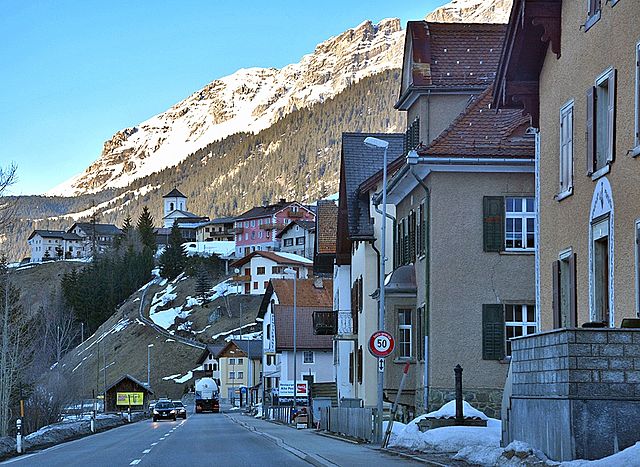
Бевер (Bever, Bever)

- коммуна
 Hiking in Бевер
Bever, Switzerland, is a charming village located in the Engadin Valley and is part of the UNESCO Biosphere Reserve. It offers incredible hiking opportunities amidst stunning alpine scenery, making it an attractive destination for both novice and seasoned hikers. Here are some key details about hiking in Bever:
Hiking Trails
- Bever to S-chanf: A gentle trail that follows the River Inn, perfect for a relaxed hike and suitable for families.
- Muottas Muragl: A popular hike starting from Bever, leading to magnificent panoramic views at Muottas Muragl. The trail can be accessed via a funicular.
- Bever to Maloja: This trail takes you through lush meadows and scenic landscapes, ideal for those looking for a longer trek with various views.
- Engadin Valley Trails: There are many well-marked hiking paths in the region, suitable for all fitness levels. You can select easier trails along the lakes or challenge yourself with steeper ascents.
Scenic Highlights
- Views of the Alps: Many of the trails offer breathtaking views of the surrounding mountains, including the Bernina Range.
- Lakes and Streams: The area is dotted with beautiful lakes such as Lake Silvaplana and Lake Sils, which you can often reach on foot.
- Wildlife: Keep an eye out for local wildlife, as the region is home to various species, including marmots, chamois, and diverse bird species.
Practical Tips
- Season: Summer (June to September) is the best time for hiking, with most trails accessible and the weather usually stable. Winter hiking is also possible, but trails may vary in difficulty.
- Gear: Proper hiking boots, weather-appropriate clothing, and sufficient water are essential. Trekking poles can be helpful on steeper sections.
- Navigation: Use local maps or hiking apps, as paths are well-marked, but it's advisable to have a map for less traveled routes.
- Local Insights: Consider visiting the local tourist information center for guidance and tips on the best trails based on your experience level.
Additional Activities
Apart from hiking, Bever offers opportunities for mountain biking, horseback riding, and enjoying the local culture and cuisine in cozy alpine lodges.
Whether you're looking for a leisurely walk or an adventurous hike, Bever is a fantastic base to explore the stunning natural beauty of the Swiss Alps!
- Страна:

- Почтовый код: 7502
- Телефонный код: 081
- Код автомобильного номера: GR
- Координаты: 46° 32' 59" N, 9° 52' 59" E


- GPS треки (wikiloc): [Ссылка]
- Высота над уровнем моря: 2653 м m
- Площадь: 47.75 кв.км
- Население: 598
- Веб сайт: http://www.bever.ch
- Википедия русская: wiki(ru)
- Википедия английская: wiki(en)
- Википедия национальная: wiki(de)
- Хранилище Wikidata: Wikidata: Q69121
- Катеория в википедии: [Ссылка]
- код Freebase: [/m/0crmnw]
- код GeoNames: Альт: [7285230]
- ID отношения в OpenStreetMap: [1684045]
- код LCNAF: Альт: [n2010040659]
- идентификатор HDS: [1537]
- код швейцарского муниципалитета: [3781]
Граничит с регионами:


Сур
Hiking in Сур
Sur is a charming village located in the Swiss canton of Grisons (Graubünden) and offers impressive hiking opportunities, primarily for those who love the beautiful landscapes of the Swiss Alps. Here’s an overview of what you can expect:...
- Страна:
- Почтовый код: 7456
- Телефонный код: 081
- Код автомобильного номера: GR
- Координаты: 46° 30' 59" N, 9° 36' 59" E
- GPS треки (wikiloc): [Ссылка]
- Высота над уровнем моря: 1530 м m
- Площадь: 23.22 кв.км
- Веб сайт: [Ссылка]


Марморера
Hiking in Марморера
Marmorera is a picturesque area located in the canton of Graubünden in Switzerland, known for its stunning landscapes, diverse hiking trails, and tranquil atmosphere. Here are some key points to consider if you're planning to hike in Marmorera:...
- Страна:
- Почтовый код: 7456
- Телефонный код: 081
- Код автомобильного номера: GR
- Координаты: 46° 29' 59" N, 9° 39' 0" E
- GPS треки (wikiloc): [Ссылка]
- Высота над уровнем моря: 1720 м m
- Площадь: 18.90 кв.км
- Веб сайт: [Ссылка]


Ла-Пунт-Чамуэшч
Hiking in Ла-Пунт-Чамуэшч
La Punt-Chamues-ch is a picturesque village located in the Engadin valley of Switzerland, known for its stunning landscapes, traditional architecture, and excellent hiking opportunities. Here are some key aspects to consider when hiking in this beautiful region:...
- Страна:
- Почтовый код: 7522
- Телефонный код: 081
- Код автомобильного номера: GR
- Координаты: 46° 33' 59" N, 9° 54' 59" E
- GPS треки (wikiloc): [Ссылка]
- Высота над уровнем моря: 1687 м m
- Площадь: 63.27 кв.км
- Население: 712
- Веб сайт: [Ссылка]

Тиницонг-Рона
Hiking in Тиницонг-Рона
Tinizong-Rona is a beautiful area located in the canton of Graubünden in Switzerland, known for its stunning landscapes and rich natural biodiversity. Hiking in this region offers a plethora of trails suitable for various skill levels, ranging from beginners to advanced hikers. Here's an overview of what you can expect when hiking in Tinizong-Rona:...
- Страна:
- Почтовый код: 7453
- Телефонный код: 081
- Код автомобильного номера: GR
- Координаты: 46° 35' 0" N, 9° 37' 0" E
- GPS треки (wikiloc): [Ссылка]
- Высота над уровнем моря: 1232 м m
- Площадь: 54.30 кв.км


Мадулайн
Hiking in Мадулайн
Madulain is a picturesque village located in the Engadine Valley of Switzerland, known for its stunning landscapes and opportunities for hiking. Nestled at an altitude of about 1,400 meters (4,600 feet), it serves as an excellent base for exploring the surrounding natural beauty. Here are some highlights related to hiking in and around Madulain:...
- Страна:
- Почтовый код: 7523
- Телефонный код: 081
- Код автомобильного номера: GR
- Координаты: 46° 32' 46" N, 9° 57' 57" E
- GPS треки (wikiloc): [Ссылка]
- Высота над уровнем моря: 2270 м m
- Площадь: 16.28 кв.км
- Население: 209
- Веб сайт: [Ссылка]


Бергюн
Hiking in Бергюн
Bergün, located in the scenic Albula Valley in the Swiss canton of Graubünden, is a fantastic destination for hiking enthusiasts. The area offers a variety of trails that cater to different skill levels, making it suitable for families, casual hikers, and experienced trekkers alike. Here are some highlights of hiking in Bergün:...
- Страна:
- Почтовый код: 7482
- Телефонный код: 081
- Код автомобильного номера: GR
- Координаты: 46° 37' 26" N, 9° 47' 14" E
- GPS треки (wikiloc): [Ссылка]
- Высота над уровнем моря: 1367 м m
- Площадь: 145.65 кв.км
- Население: 480
- Веб сайт: [Ссылка]


Самедан
Hiking in Самедан
Samedan, located in the Engadin Valley of Switzerland, is a beautiful destination for hiking enthusiasts. The region offers a mix of stunning landscapes, picturesque villages, and a range of trails suited for different skill levels. Here are some highlights of hiking in Samedan:...
- Страна:
- Почтовый код: 7503
- Телефонный код: 081
- Код автомобильного номера: GR
- Координаты: 46° 32' 1" N, 9° 52' 19" E
- GPS треки (wikiloc): [Ссылка]
- Высота над уровнем моря: 2970 м m
- Площадь: 113.80 кв.км
- Население: 2956
- Веб сайт: [Ссылка]