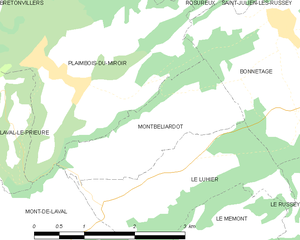
Bonnétage (Bonnétage)

- коммуна во Франции
 Hiking in Bonnétage
Bonnétage, located in the Doubs department of the Bourgogne-Franche-Comté region in eastern France, is a beautiful destination for hiking enthusiasts. Nestled in the Jura Mountains, the area offers stunning landscapes, lush forests, and panoramic views, making it an ideal location for outdoor activities.
Hiking Trails:
-
Les Sentiers de la Nature: This network of trails around Bonnétage features varying levels of difficulty, suitable for both beginners and experienced hikers. The paths often wind through dense forests and along clear streams.
-
Circuits de la Vallée du Doubs: This trail follows the Doubs River and provides stunning views of the surrounding hills and valleys. It's an excellent choice for those who appreciate natural beauty and want to enjoy a relatively easy hike.
-
Mont d'Or Trails: For those looking for a more challenging hike, trails leading up to the Mont d'Or offer steep ascents and reward hikers with breathtaking vistas from the summit.
Flora and Fauna:
The area is rich in biodiversity, with a variety of plant species and wildlife. You might encounter deer, foxes, and numerous bird species along the trails, making it a perfect spot for nature lovers.
Tips for Hiking in Bonnétage:
-
Check the Weather: The weather can change rapidly in the Jura Mountains, so it’s essential to check forecasts and dress accordingly.
-
Stay on Marked Paths: While exploring the natural beauty, it’s crucial to stay on designated trails to protect the ecosystem and ensure your safety.
-
Bring Essentials: Make sure to carry enough water, snacks, and a first-aid kit. A map or GPS device can be helpful, especially on less-marked trails.
-
Respect Nature: Follow the Leave No Trace principles to preserve the area's natural habitat and ensure it remains beautiful for future visitors.
-
Seasonal Considerations: Spring and autumn are particularly lovely for hiking due to the mild weather and vibrant foliage. Summer can be warmer, so start early in the day to avoid the heat.
Hiking in Bonnétage can be a rewarding experience for those looking to connect with nature and enjoy the stunning landscapes of eastern France.
- Страна:

- Почтовый код: 25210
- Координаты: 47° 11' 5" N, 6° 43' 24" E


- GPS треки (wikiloc): [Ссылка]
- Площадь: 17.71 кв.км
- Население: 887
- Википедия английская: wiki(en)
- Википедия национальная: wiki(fr)
- Хранилище Wikidata: Wikidata: Q838061
- Катеория в википедии: [Ссылка]
- код Freebase: [/m/03mgrcw]
- код Freebase: [/m/03mgrcw]
- код GeoNames: Альт: [6447850]
- код GeoNames: Альт: [6447850]
- номер SIREN: [212500748]
- номер SIREN: [212500748]
- код BNF: [15252300j]
- код BNF: [15252300j]
- код муниципалитета INSEE: 25074
- код муниципалитета INSEE: 25074
Граничит с регионами:

Montbéliardot
- коммуна во Франции
Hiking in Montbéliardot
Montbéliardot is a beautiful area that is not widely known among hikers, but it offers natural beauty, picturesque landscapes, and opportunities for outdoor activities. While detailed hiking trails may not be specifically documented for Montbéliardot, the surrounding regions in the Doubs department and nearby areas can provide excellent hiking experiences....
- Страна:
- Почтовый код: 25210
- Координаты: 47° 10' 31" N, 6° 39' 16" E
- GPS треки (wikiloc): [Ссылка]
- Площадь: 3.8 кв.км
- Население: 114

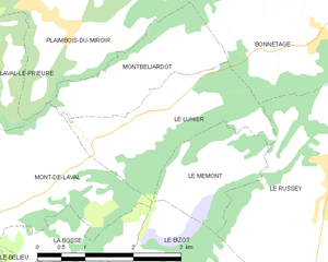
Le Luhier
- коммуна во Франции
Hiking in Le Luhier
Le Luhier is a picturesque region that offers a variety of hiking trails for both beginners and experienced hikers. Nestled in nature, this area features stunning landscapes, including dense forests, rolling hills, and picturesque streams. While I don’t have specific details on Le Luhier itself, I can give you some general tips and advice for hiking in such areas....
- Страна:
- Почтовый код: 25210
- Координаты: 47° 10' 6" N, 6° 39' 34" E
- GPS треки (wikiloc): [Ссылка]
- Площадь: 5.21 кв.км
- Население: 212


Ла-Шо-де-Фон
Hiking in Ла-Шо-де-Фон
La Chaux-de-Fonds, located in the Swiss Jura Mountains, is known for its rich watchmaking history and stunning landscapes, making it a great destination for hiking enthusiasts. The area offers a variety of trails that cater to different skill levels, from leisurely strolls to challenging hikes....
- Страна:

- Почтовый код: 2300
- Телефонный код: 032
- Код автомобильного номера: NE
- Координаты: 47° 5' 59" N, 6° 49' 46" E
- GPS треки (wikiloc): [Ссылка]
- Высота над уровнем моря: 997 м m
- Площадь: 5566 кв.км
- Население: 38965
- Веб сайт: [Ссылка]


Frambouhans
- коммуна во Франции
Hiking in Frambouhans
Frambouhans is a charming village located in the Jura department of France. The region is known for its stunning natural landscapes, including forests, rolling hills, and picturesque viewpoints, making it an appealing destination for hiking enthusiasts....
- Страна:
- Почтовый код: 25140
- Координаты: 47° 13' 10" N, 6° 46' 3" E
- GPS треки (wikiloc): [Ссылка]
- Площадь: 10.1 кв.км
- Население: 881
- Веб сайт: [Ссылка]


Le Russey
- коммуна во Франции
Hiking in Le Russey
Le Russey is a charming commune located in the Doubs department in the Bourgogne-Franche-Comté region of eastern France. It's nestled in a picturesque part of the Jura Mountains, which offers a variety of scenic hiking opportunities. Here are some points to consider when hiking in and around Le Russey:...
- Страна:
- Почтовый код: 25210
- Координаты: 47° 9' 46" N, 6° 43' 48" E
- GPS треки (wikiloc): [Ссылка]
- Площадь: 24.17 кв.км
- Население: 2282
- Веб сайт: [Ссылка]


Les Fontenelles
- коммуна во Франции
Hiking in Les Fontenelles
Les Fontenelles is a beautiful area located in the French region of Pays de la Loire, specifically in the Vendée department. This region is known for its varied landscapes, stunning natural beauty, and a range of outdoor activities, including hiking. Here’s a guide for hiking in Les Fontenelles:...
- Страна:
- Почтовый код: 25210
- Координаты: 47° 11' 58" N, 6° 44' 38" E
- GPS треки (wikiloc): [Ссылка]
- Площадь: 8.38 кв.км
- Население: 566
- Веб сайт: [Ссылка]


Fournet-Blancheroche
- коммуна во Франции
Hiking in Fournet-Blancheroche
Fournet-Blancheroche is a picturesque village located in the Doubs department of the Bourgogne-Franche-Comté region in eastern France. It is an excellent destination for hiking enthusiasts due to its beautiful natural landscapes, rolling hills, and proximity to the Jura Mountains. Here are some highlights and tips for hiking in Fournet-Blancheroche:...
- Страна:
- Почтовый код: 25140
- Координаты: 47° 10' 4" N, 6° 49' 34" E
- GPS треки (wikiloc): [Ссылка]
- Площадь: 13.08 кв.км
- Население: 373
Saint-Julien-lès-Russey
- коммуна во Франции
Hiking in Saint-Julien-lès-Russey
Saint-Julien-lès-Russey is a charming commune located in the Doubs department of the Bourgogne-Franche-Comté region in eastern France. It's surrounded by beautiful natural landscapes, making it a great spot for hiking enthusiasts. Here are some highlights you might enjoy:...
- Страна:
- Почтовый код: 25210
- Координаты: 47° 13' 2" N, 6° 43' 28" E
- GPS треки (wikiloc): [Ссылка]
- Высота над уровнем моря: 550 м m
- Площадь: 10.01 кв.км
- Население: 163

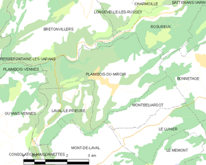
Plaimbois-du-Miroir
- коммуна во Франции
Hiking in Plaimbois-du-Miroir
Plaimbois-du-Miroir is a charming village located in the Jura region of France, known for its picturesque landscapes and outdoor activities, including hiking. The Jura Mountains offer a variety of trails that cater to hikers of different skill levels. Here are some highlights:...
- Страна:
- Почтовый код: 25210
- Координаты: 47° 11' 29" N, 6° 38' 43" E
- GPS треки (wikiloc): [Ссылка]
- Площадь: 11.71 кв.км
- Население: 238


Rosureux
- коммуна во Франции
Hiking in Rosureux
Rosureux is a beautiful destination for hiking enthusiasts, featuring a mix of scenic trails, diverse landscapes, and varying levels of difficulty. While the information may be slightly limited due to its lesser-known status, here are some general highlights you might expect when hiking in the Rosureux area:...
- Страна:
- Почтовый код: 25380
- Координаты: 47° 13' 6" N, 6° 41' 14" E
- GPS треки (wikiloc): [Ссылка]
- Площадь: 6.14 кв.км
- Население: 78
Grand'Combe-des-Bois
- коммуна во Франции
Hiking in Grand'Combe-des-Bois
Grand'Combe-des-Bois, located in the Doubs department in the Bourgogne-Franche-Comté region of eastern France, offers a picturesque setting for hiking enthusiasts. Known for its stunning natural landscapes, the area features rolling hills, dense forests, and a variety of wildlife, making it ideal for outdoor activities....
- Страна:
- Почтовый код: 25210
- Координаты: 47° 8' 16" N, 6° 47' 27" E
- GPS треки (wikiloc): [Ссылка]
- Площадь: 11.87 кв.км
- Население: 137