
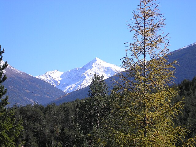
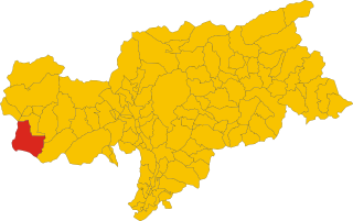
Бормио (Bormio, Bormio)
.svg)
- коммуна Италии
 Hiking in Бормио
Bormio is a beautiful town located in the Italian Alps, specifically within the Lombardy region. It's well known for its stunning landscapes, rich history, and access to a variety of outdoor activities, including hiking. Here’s an overview of what to expect when hiking in Bormio:
Hiking Trails
Bormio and its surrounding area offer numerous hiking trails suitable for all skill levels:
-
Easy Trails:
- Sentiero del Viandante: A scenic and relatively easy hiking path that offers beautiful views of the Valtellina valley.
- Bormio to the Thermal Baths: A short, easy trek that takes you from Bormio to nearby thermal baths, perfect for a relaxing break.
-
Moderate Trails:
- Cima Bianca: A moderately challenging hike that offers spectacular views of the surrounding mountains and valleys.
- Val delle Forbici: This route takes you through lush forests with the option of reaching higher altitudes for better views.
-
Challenging Trails:
- Monte Scale: A strenuous hike that takes you to the summit of Monte Scale, rewarding you with breathtaking alpine scenery.
- Passo di Via Bormina: A more demanding hike that traverses higher elevations with beautiful vistas.
Scenic Beauty
Hiking in Bormio allows you to immerse yourself in the stunning natural beauty of the Italian Alps, featuring lush meadows, dense forests, and striking mountain peaks. Wildlife enthusiasts may spot various wildlife species, including ibex, chamois, and diverse bird species.
Best Time to Hike
The hiking season typically runs from late spring (May) to early autumn (October), depending on snow conditions in high-altitude areas. For the best experience, consider hiking during summer when the weather is generally milder, and flowers are in bloom.
Tips for Hiking in Bormio
- Wear Appropriate Gear: Good hiking boots, layers for changing weather conditions, and a rain jacket are essential.
- Stay Hydrated: Always carry enough water, especially on longer hikes.
- Study Maps and Trails: Familiarize yourself with trail maps and note the difficulty level of each route before heading out.
- Check Weather Conditions: The weather in the mountains can change rapidly; check forecasts before your hike.
- Respect Nature: Follow Leave No Trace principles to preserve the natural beauty of the area.
Local Culture
Utilizing the hiking trails also offers opportunities to experience local culture, including traditional Alpine huts (rifugi) where hikers can enjoy local cuisine and hospitality.
Overall, hiking in Bormio provides a rejuvenating experience, combining physical activity with the chance to appreciate the breathtaking landscapes and rich cultural heritage of the region.
- Страна:

- Почтовый код: 23032
- Телефонный код: 0342
- Код автомобильного номера: SO
- Координаты: 46° 28' 0" N, 10° 22' 0" E


- GPS треки (wikiloc): [Ссылка]
- Высота над уровнем моря: 1225 м m
- Площадь: 41.44 кв.км
- Население: 4194
- Веб сайт: http://www.comune.bormio.so.it/
- Википедия русская: wiki(ru)
- Википедия английская: wiki(en)
- Википедия национальная: wiki(it)
- Хранилище Wikidata: Wikidata: Q40516
- Галерея изображений в википедии: [Ссылка]
- Катеория в википедии: [Ссылка]
- код Freebase: [/m/09265q]
- код GeoNames: Альт: [6536122]
- код VIAF: Альт: [140808889]
- ID отношения в OpenStreetMap: [47222]
- UN/LOCODE: [ITBMI]
- идентификатор HDS: [7031]
- код в Большой российской энциклопедии онлайн: [1878732]
- код Цифрового атласа Римской империи: [10550]
- код Pleiades: [187289]
- код в Итальянской энциклопедии онлайн: [bormio]
- код в Итальянской энциклопедии: [bormio]
- код ISTAT: 014009
- кадастровый код Италии: B049
Граничит с регионами:

Вальфурва
- коммуна Италии
Hiking in Вальфурва
Valfurva, located in the Lombardy region of northern Italy, is a beautiful destination for hiking enthusiasts, offering stunning alpine scenery and a variety of trails suitable for different skill levels. The area is part of the Stelvio National Park, which is known for its diverse landscapes, including mountains, forests, and meadows....
- Страна:
- Почтовый код: 23030
- Телефонный код: 0342
- Код автомобильного номера: SO
- Координаты: 46° 27' 0" N, 10° 25' 0" E
- GPS треки (wikiloc): [Ссылка]
- Высота над уровнем моря: 1800 м m
- Площадь: 215.02 кв.км
- Население: 2581
- Веб сайт: [Ссылка]


Вальдидентро
- коммуна Италии
Hiking in Вальдидентро
Valdidentro is a beautiful valley located in the Lombardy region of northern Italy, within the larger Valtellina area. It's an excellent spot for hiking enthusiasts, offering a variety of trails that cater to different experience levels, stunning scenery, and opportunities to explore the rich natural and cultural heritage of the region....
- Страна:
- Почтовый код: 23038
- Телефонный код: 0342
- Код автомобильного номера: SO
- Координаты: 46° 29' 0" N, 10° 18' 0" E
- GPS треки (wikiloc): [Ссылка]
- Высота над уровнем моря: 1345 м m
- Площадь: 226.73 кв.км
- Население: 4131
- Веб сайт: [Ссылка]
Вальдизотто
- коммуна Италии
Hiking in Вальдизотто
Valdisotto is a beautiful destination located in the Valtellina region of Lombardy, Italy, known for its stunning landscapes, rich natural heritage, and excellent hiking opportunities. Nestled in the Alps, Valdisotto offers a range of trails that cater to hikers of all skill levels, from easy walks to challenging alpine routes....
- Страна:
- Почтовый код: 23030
- Телефонный код: 0342
- Код автомобильного номера: SO
- Координаты: 46° 25' 0" N, 10° 21' 0" E
- GPS треки (wikiloc): [Ссылка]
- Высота над уровнем моря: 1141 м m
- Площадь: 89.57 кв.км
- Население: 3601
- Веб сайт: [Ссылка]

Стельвио
- коммуна в Италии
Hiking in Стельвио
Stilfs, also known as Stilfs or Stelvio, is a charming village located in the South Tyrol region of northern Italy. It serves as a fantastic gateway for hiking enthusiasts looking to explore the beautiful and diverse landscapes of the nearby Stelvio National Park. Here are some highlights of hiking in and around Stilfs:...
- Страна:
- Почтовый код: 39020
- Телефонный код: 0473
- Код автомобильного номера: BZ
- Координаты: 46° 35' 52" N, 10° 32' 45" E
- GPS треки (wikiloc): [Ссылка]
- Высота над уровнем моря: 1311 м m
- Площадь: 141.63 кв.км
- Население: 1150
- Веб сайт: [Ссылка]