
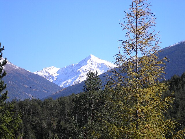
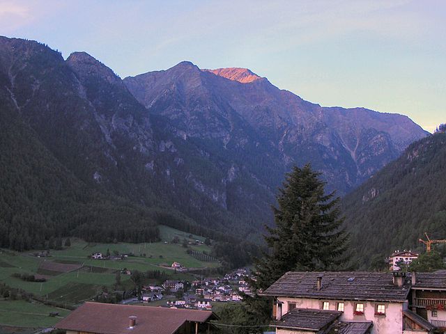
Стельвио (Stilfs, Stelvio)
.svg)
- коммуна в Италии
 Hiking in Стельвио
Stilfs, also known as Stilfs or Stelvio, is a charming village located in the South Tyrol region of northern Italy. It serves as a fantastic gateway for hiking enthusiasts looking to explore the beautiful and diverse landscapes of the nearby Stelvio National Park. Here are some highlights of hiking in and around Stilfs:
Scenic Trails
-
Stelvio National Park: The park offers numerous trails ranging from easy walks to challenging hikes. You can explore alpine meadows, lush forests, and rugged mountain terrain. Look out for well-marked paths that lead to breathtaking viewpoints.
-
Sayth Valley: An excellent trail for both families and seasoned hikers, this valley provides a moderately challenging route with stunning views of the surrounding peaks.
-
Zufritt Glacier: For those looking for a more adventurous hike, the trails leading to the Zufritt Glacier offer a spectacular experience with glacial landscapes and the chance to see wildlife like chamois and marmots.
Seasonal Considerations
- Summer: This is the prime hiking season, with most trails accessible. The weather is generally warm, and wildflowers bloom in the meadows.
- Autumn: A beautiful time to hike, as the fall foliage paints the landscape in vibrant colors. However, be prepared for shorter days and cooler weather.
- Winter: While challenging, winter hiking is possible, particularly with winter gear, and you may also find opportunities for snowshoeing or winter trails.
Tips for Hikers
-
Preparation: Ensure you're well-prepared with a good map, adequate supplies, and appropriate gear. The weather can change rapidly in the mountains.
-
Local Guides: Consider hiring a local guide or joining a guided hiking tour, especially if you're unfamiliar with the area. They can offer insights into the local flora and fauna.
-
Respect Nature: Stick to marked trails and practice Leave No Trace principles to preserve the natural beauty of the area.
Cultural Aspects
Stilfs and the surrounding areas have a rich history, with unique architecture and cultural heritage. Taking the time to explore the village and its history can enhance your hiking experience.
Hiking in Stilfs is a wonderful way to connect with nature, enjoy stunning landscapes, and experience the unique culture of South Tyrol. Happy hiking!
- Страна:

- Почтовый код: 39020
- Телефонный код: 0473
- Код автомобильного номера: BZ
- Координаты: 46° 35' 52" N, 10° 32' 45" E


- GPS треки (wikiloc): [Ссылка]
- Высота над уровнем моря: 1311 м m
- Площадь: 141.63 кв.км
- Население: 1150
- Веб сайт: http://www.comune.stelvio.bz.it/
- Википедия русская: wiki(ru)
- Википедия английская: wiki(en)
- Википедия национальная: wiki(it)
- Хранилище Wikidata: Wikidata: Q493831
- Галерея изображений в википедии: [Ссылка]
- Катеория в википедии: [Ссылка]
- код Freebase: [/m/0dhn5x]
- код GeoNames: Альт: [6535932]
- код BNF: [15604357n]
- код VIAF: Альт: [130388846]
- ID отношения в OpenStreetMap: [47231]
- код GND: Альт: [7841901-3]
- код LCNAF: Альт: [n2004042833]
- код ISTAT: 021095
- кадастровый код Италии: I948
Граничит с регионами:

Вальфурва
- коммуна Италии
Hiking in Вальфурва
Valfurva, located in the Lombardy region of northern Italy, is a beautiful destination for hiking enthusiasts, offering stunning alpine scenery and a variety of trails suitable for different skill levels. The area is part of the Stelvio National Park, which is known for its diverse landscapes, including mountains, forests, and meadows....
- Страна:
- Почтовый код: 23030
- Телефонный код: 0342
- Код автомобильного номера: SO
- Координаты: 46° 27' 0" N, 10° 25' 0" E
- GPS треки (wikiloc): [Ссылка]
- Высота над уровнем моря: 1800 м m
- Площадь: 215.02 кв.км
- Население: 2581
- Веб сайт: [Ссылка]


Бормио
- коммуна Италии
Hiking in Бормио
Bormio is a beautiful town located in the Italian Alps, specifically within the Lombardy region. It's well known for its stunning landscapes, rich history, and access to a variety of outdoor activities, including hiking. Here’s an overview of what to expect when hiking in Bormio:...
- Страна:
- Почтовый код: 23032
- Телефонный код: 0342
- Код автомобильного номера: SO
- Координаты: 46° 28' 0" N, 10° 22' 0" E
- GPS треки (wikiloc): [Ссылка]
- Высота над уровнем моря: 1225 м m
- Площадь: 41.44 кв.км
- Население: 4194
- Веб сайт: [Ссылка]


Лаза
- коммуна Италии
Hiking in Лаза
Laas, located in the stunning South Tyrol region of northern Italy, is a small village known for its beautiful landscapes and excellent hiking opportunities. Nestled in the heart of the Alps, Laas boasts a mix of gentle trails and more challenging routes, making it suitable for hikers of all levels....
- Страна:
- Почтовый код: 39023
- Телефонный код: 0473
- Код автомобильного номера: BZ
- Координаты: 46° 37' 4" N, 10° 41' 52" E
- GPS треки (wikiloc): [Ссылка]
- Высота над уровнем моря: 868 м m
- Площадь: 110.23 кв.км
- Население: 4028
- Веб сайт: [Ссылка]

Мартелло
- коммуна Италии
Hiking in Мартелло
Martell is a picturesque valley located in South Tyrol, Italy, known for its breathtaking landscapes, diverse flora and fauna, and excellent hiking trails. Here are some key points to consider if you're planning a hiking trip to Martell:...
- Страна:
- Почтовый код: 39020
- Телефонный код: 0473
- Код автомобильного номера: BZ
- Координаты: 46° 33' 17" N, 10° 46' 50" E
- GPS треки (wikiloc): [Ссылка]
- Высота над уровнем моря: 1312 м m
- Площадь: 142.8 кв.км
- Население: 853
- Веб сайт: [Ссылка]


Прато-алло-Стельвио
- коммуна в Италии
Hiking in Прато-алло-Стельвио
Prad am Stilfser Joch is a charming village located in the South Tyrol region of Italy, nestled at the entrance to the Stilfser Joch National Park. This area is renowned for its stunning natural landscapes, mountainous terrain, and excellent hiking opportunities. Here are some highlights and tips for hiking in this region:...
- Страна:
- Почтовый код: 39026
- Телефонный код: 0473
- Код автомобильного номера: BZ
- Координаты: 46° 37' 8" N, 10° 35' 29" E
- GPS треки (wikiloc): [Ссылка]
- Высота над уровнем моря: 3375 м m
- Площадь: 51.49 кв.км
- Население: 3474
- Веб сайт: [Ссылка]


Тубре
- коммуна в Италии
Hiking in Тубре
Taufers im Münstertal, located in the Bavarian Alps in South Tyrol, Italy, offers a stunning backdrop for hiking enthusiasts of all levels. The area is characterized by its picturesque valleys, lush forests, and panoramic mountain views, making it an ideal destination for nature lovers....
- Страна:
- Почтовый код: 39020
- Телефонный код: 0473
- Код автомобильного номера: BZ
- Координаты: 46° 38' 39" N, 10° 27' 48" E
- GPS треки (wikiloc): [Ссылка]
- Высота над уровнем моря: 1240 м m
- Площадь: 46.27 кв.км
- Население: 981
- Веб сайт: [Ссылка]