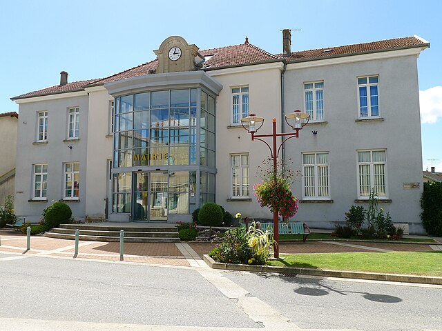
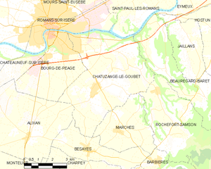
Бур-дё-Пеаж (Bourg-de-Péage, Bourg-de-Péage)

- коммуна во Франции
 Hiking in Бур-дё-Пеаж
Bourg-de-Péage is a charming commune located in the Drôme department of southeastern France, known for its picturesque landscapes and proximity to the Rhône Alps, making it a great base for hiking enthusiasts. Here are some highlights and tips for hiking in and around Bourg-de-Péage:
Local Trails
-
Vercors Regional Natural Park: Just a short drive from Bourg-de-Péage, this park offers extensive hiking trails that range from easy walks to more challenging routes. The Vercors massif is known for its stunning cliffs, deep gorges, and diverse flora and fauna.
-
Bourne Gorges: A popular hiking area located near Bourg-de-Péage, these gorges provide spectacular views and opportunities for wildlife spotting. There are well-marked trails suitable for both beginners and seasoned hikers.
-
Col de Rousset: Located a bit further away but still accessible, this area offers beautiful panoramic views and challenging hikes. The trails here can be more rugged, suitable for experienced hikers looking for adventure.
Tips for Hiking in Bourg-de-Péage
- Weather Considerations: Always check the weather before heading out. The conditions can change rapidly, especially in mountainous regions.
- Proper Gear: Wear sturdy hiking boots, and consider trekking poles for challenging trails. Also, carry a backpack with water, snacks, a first-aid kit, and a map or GPS.
- Trail Etiquette: Stay on marked trails, respect wildlife, and follow local guidelines to preserve the natural environment.
- Local Guidance: If you are unfamiliar with the area, consider joining a guided hike or connecting with local hiking clubs for advice and companionship.
Nearby Attractions
- Valence: A short drive from Bourg-de-Péage, Valence offers additional hiking options and cultural sites, including historical architecture and local markets.
- Caves and Cliffs: Explore natural caves and cliff formations in the nearby region, which can offer interesting side hikes or excursions.
Overall, Bourg-de-Péage is an excellent starting point for exploring the scenic beauty of the Drôme region and the Vercors, providing a mix of easy and challenging hikes for all levels. Always remember to hike responsibly, respecting both nature and local communities. Happy hiking!
- Страна:

- Почтовый код: 26300
- Координаты: 45° 2' 16" N, 5° 3' 0" E


- GPS треки (wikiloc): [Ссылка]
- Высота над уровнем моря: 135 м m
- Площадь: 13.71 кв.км
- Население: 10497
- Веб сайт: http://www.bourgdepeage.com
- Википедия английская: wiki(en)
- Википедия национальная: wiki(fr)
- Хранилище Wikidata: Wikidata: Q240363
- Катеория в википедии: [Ссылка]
- код Freebase: [/m/07vzb4]
- код GeoNames: Альт: [3031020]
- номер SIREN: [212600571]
- код BNF: [152529188]
- код VIAF: Альт: [146587135]
- код LCNAF: Альт: [n81022957]
- код муниципалитета INSEE: 26057
Граничит с регионами:


Роман-сюр-Изер
- коммуна во Франции
Hiking in Роман-сюр-Изер
Romans-sur-Isère is a charming town located in the Drôme department in southeastern France. Nestled near the banks of the Isère River, the area offers a variety of hiking opportunities that allow you to explore the natural beauty of the region....
- Страна:
- Почтовый код: 26100
- Координаты: 45° 2' 44" N, 5° 3' 3" E
- GPS треки (wikiloc): [Ссылка]
- Площадь: 33.08 кв.км
- Население: 33465
- Веб сайт: [Ссылка]


Alixan
- коммуна во Франции
Hiking in Alixan
Alixan is a charming commune located in the Drôme department of southeastern France. While it may not be as well-known as some of the more prominent hiking destinations, it offers a serene landscape and opportunities for outdoor activities, including hiking....
- Страна:
- Почтовый код: 26300
- Координаты: 44° 58' 30" N, 5° 1' 39" E
- GPS треки (wikiloc): [Ссылка]
- Площадь: 28.28 кв.км
- Население: 2484
Chatuzange-le-Goubet
- коммуна во Франции
Hiking in Chatuzange-le-Goubet
Chatuzange-le-Goubet is a charming commune located in the Drôme department of southeastern France, nestled near the picturesque foothills of the Alps. While the area is not as widely recognized for hiking as some of its neighboring regions, it still offers beautiful landscapes and serene trails that can appeal to outdoor enthusiasts....
- Страна:
- Почтовый код: 26300
- Координаты: 45° 0' 24" N, 5° 5' 27" E
- GPS треки (wikiloc): [Ссылка]
- Высота над уровнем моря: 238 м m
- Площадь: 28.24 кв.км
- Население: 5311
- Веб сайт: [Ссылка]


Châteauneuf-sur-Isère
- коммуна во Франции
Hiking in Châteauneuf-sur-Isère
Châteauneuf-sur-Isère is a charming commune located in the Auvergne-Rhône-Alpes region of southeastern France, not far from the town of Valence. The area is characterized by its picturesque landscapes, rolling hills, and proximity to the Drôme River, making it an attractive spot for outdoor activities, including hiking....
- Страна:
- Почтовый код: 26300
- Координаты: 45° 0' 50" N, 4° 56' 5" E
- GPS треки (wikiloc): [Ссылка]
- Высота над уровнем моря: 155 м m
- Площадь: 45.57 кв.км
- Население: 3839
- Веб сайт: [Ссылка]