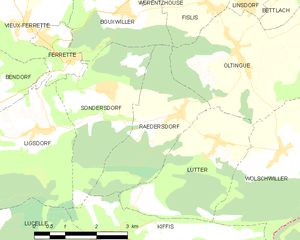
Буксвиллер (Bouxwiller, Bouxwiller)

- коммуна во Франции
 Hiking in Буксвиллер
Bouxwiller is a charming village located in the Haut-Rhin department of France, known for its beautiful landscapes and scenic hiking opportunities. The region offers a variety of trails that cater to different skill levels, making it suitable for both beginner and experienced hikers.
Key Hiking Features:
-
Scenic Trails: The area around Bouxwiller features picturesque landscapes, including rolling hills, forests, and vineyards. Many trails provide stunning views of the Vosges Mountains and the Alsace plain.
-
Trail Diversity: You can find a mix of easy walks suitable for families and more challenging hikes for those looking for a workout. Some trails might take you through historical sites, charming villages, and local farms, enriching your hiking experience.
-
Nature Reserves: The region is home to various nature reserves where hikers can enjoy untouched natural environments, diverse flora, and fauna. These areas are perfect for birdwatching and appreciating the natural beauty of the Haut-Rhin.
-
Local Tips: Always check local maps and guides for the best hiking routes. Inform yourself about the weather conditions before heading out, as they can change rapidly in this area.
-
Accessibility: Bouxwiller is relatively accessible, making it an excellent starting point for hikes leading into the surrounding countryside. Ensure you have appropriate footwear and plenty of water, especially when tackling longer trails.
Suggested Trails:
-
Sentier des Vosges: This long-distance trail passes through the region, offering diverse landscapes and experiences along the way.
-
Local Nature Trails: Look for shorter loops around the village that are great for a quick hike and family outings.
If you're in Bouxwiller, don’t hesitate to stop by local tourist information centers for up-to-date trail maps and additional recommendations on where to hike and what to see! Enjoy your hiking adventure!
- Страна:

- Почтовый код: 68480
- Координаты: 47° 30' 18" N, 7° 20' 45" E


- GPS треки (wikiloc): [Ссылка]
- Площадь: 6.47 кв.км
- Население: 463
- Википедия русская: wiki(ru)
- Википедия английская: wiki(en)
- Википедия национальная: wiki(fr)
- Хранилище Wikidata: Wikidata: Q325747
- Катеория в википедии: [Ссылка]
- код Freebase: [/m/03nt5cm]
- код Freebase: [/m/03nt5cm]
- код GeoNames: Альт: [6614330]
- код GeoNames: Альт: [6614330]
- номер SIREN: [216800490]
- номер SIREN: [216800490]
- код BNF: [15271751q]
- код BNF: [15271751q]
- код муниципалитета INSEE: 68049
- код муниципалитета INSEE: 68049
Граничит с регионами:


Вьё-Феррет
- коммуна во Франции
Hiking in Вьё-Феррет
Vieux-Ferrette is a charming village located in the Alsace region of northeastern France, near the border with Switzerland and Germany. This area is often celebrated for its picturesque landscapes, rich history, and diverse outdoor activities, making it a great destination for hiking enthusiasts....
- Страна:
- Почтовый код: 68480
- Координаты: 47° 30' 9" N, 7° 17' 57" E
- GPS треки (wikiloc): [Ссылка]
- Площадь: 6.63 кв.км
- Население: 673


Ольтен
- коммуна во Франции
Hiking in Ольтен
Oltingue is a small commune located in the Haut-Rhin department of eastern France, near the border with Switzerland. Hiking in this area can be quite rewarding, as it offers beautiful landscapes and the chance to experience the unique flora and fauna of the region....
- Страна:
- Почтовый код: 68480
- Координаты: 47° 29' 29" N, 7° 23' 30" E
- GPS треки (wikiloc): [Ссылка]
- Площадь: 13.42 кв.км
- Население: 721
- Веб сайт: [Ссылка]

Редерсдорф
- коммуна во Франции
Hiking in Редерсдорф
Raedersdorf is a small village located in the Alsace region of France, not far from the German border. It offers a serene environment perfect for hiking enthusiasts who want to explore the scenic beauty of the area. Here are some details and tips for hiking in and around Raedersdorf:...
- Страна:
- Почтовый код: 68480
- Координаты: 47° 28' 30" N, 7° 22' 0" E
- GPS треки (wikiloc): [Ссылка]
- Площадь: 7.39 кв.км
- Население: 506


Сондерсдорф
- коммуна во Франции
Hiking in Сондерсдорф
Sondersdorf, a small town located in Bavaria, Germany, offers access to beautiful hiking trails and scenic landscapes typical of the region. The area is known for its rolling hills, lush forests, and picturesque farmland, making it an ideal location for hikers of all levels....
- Страна:
- Почтовый код: 68480
- Координаты: 47° 28' 59" N, 7° 20' 7" E
- GPS треки (wikiloc): [Ссылка]
- Площадь: 8.44 кв.км
- Население: 343

Фислис
- коммуна во Франции
Hiking in Фислис
Fislis is not a well-documented hiking destination, so it's possible you might be referring to a specific area, trail, or region that goes by a similar name. However, if you're looking for hiking information in a general context, here's what you can consider if you’re exploring a typical hiking geography:...
- Страна:
- Почтовый код: 68480
- Координаты: 47° 30' 16" N, 7° 22' 54" E
- GPS треки (wikiloc): [Ссылка]
- Площадь: 7.53 кв.км
- Население: 423
- Веб сайт: [Ссылка]

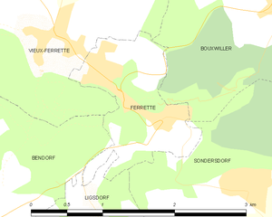
Феррет
- коммуна во Франции
Hiking in Феррет
Ferrette, a picturesque small town located in the Alsace region of France, is nestled near the border with Switzerland. It offers a variety of hiking opportunities, surrounded by beautiful landscapes, forests, and rolling hills. Here are some highlights and tips for hiking in the Ferrette area:...
- Страна:
- Почтовый код: 68480
- Координаты: 47° 29' 38" N, 7° 18' 57" E
- GPS треки (wikiloc): [Ссылка]
- Площадь: 1.94 кв.км
- Население: 683


Дюрменаш
- коммуна во Франции
Hiking in Дюрменаш
Durmenach is a charming area surrounded by beautiful landscapes, ideal for hiking enthusiasts. While specific trail information may vary, here are general points about hiking in and around Durmenach:...
- Страна:
- Почтовый код: 68480
- Координаты: 47° 31' 37" N, 7° 20' 17" E
- GPS треки (wikiloc): [Ссылка]
- Площадь: 5.76 кв.км
- Население: 859

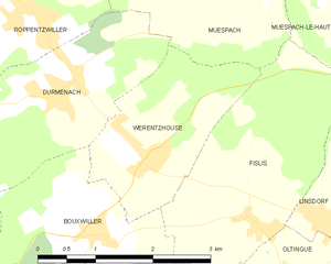
Верентсуз
- коммуна во Франции
Hiking in Верентсуз
Werentzhouse, located in the Alsace region of France, is not a widely known hiking destination, but the surrounding area offers beautiful landscapes and opportunities for outdoor activities. The region is characterized by its rolling hills, vineyards, and picturesque villages, making it a lovely place to explore on foot. Here are some key points to consider when hiking in and around Werentzhouse:...
- Страна:
- Почтовый код: 68480
- Координаты: 47° 31' 1" N, 7° 21' 27" E
- GPS треки (wikiloc): [Ссылка]
- Площадь: 4.5 кв.км
- Население: 560