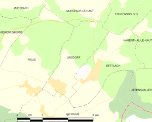
Ольтен (Oltingue, Oltingue)

- коммуна во Франции
 Hiking in Ольтен
Oltingue is a small commune located in the Haut-Rhin department of eastern France, near the border with Switzerland. Hiking in this area can be quite rewarding, as it offers beautiful landscapes and the chance to experience the unique flora and fauna of the region.
Hiking Highlights in Oltingue:
-
Scenic Trails: The trails around Oltingue often lead through picturesque countryside, rolling hills, and forests. The terrain can vary, offering both gentle paths suitable for beginners and more challenging routes for experienced hikers.
-
Nearby Natural Parks: The region is close to the Ballon d'Alsace Natural Park and the Jura Mountains, which provide a wider range of hiking options. These areas are known for their stunning views, diverse ecosystems, and well-marked paths.
-
Cultural Aspects: Hiking in Oltingue allows you to explore the local culture as well. Historic sites and traditional Alsatian architecture can often be found along the trails, making for an enriching experience.
-
Flora and Fauna: The region's diverse ecosystems support a variety of plants and animals. Birdwatching and plant identification can add an extra dimension to your hikes.
-
Seasonal Considerations: The best time to hike in Oltingue is during the spring and fall, when temperatures are mild and the scenery is particularly beautiful. However, summer can also be a lovely time to visit, although it's advisable to start hikes early to avoid the midday heat.
-
Preparation: As with any hiking adventure, it's essential to prepare adequately. Make sure you have proper footwear, enough water, snacks, a map, and an understanding of the local weather conditions.
If you're looking for a mix of natural beauty, cultural experiences, and varied hiking trails, Oltingue can be a wonderful destination to explore on foot!
- Страна:

- Почтовый код: 68480
- Координаты: 47° 29' 29" N, 7° 23' 30" E


- GPS треки (wikiloc): [Ссылка]
- Площадь: 13.42 кв.км
- Население: 721
- Веб сайт: http://www.oltingue.fr
- Википедия русская: wiki(ru)
- Википедия английская: wiki(en)
- Википедия национальная: wiki(fr)
- Хранилище Wikidata: Wikidata: Q147882
- Катеория в википедии: [Ссылка]
- код Freebase: [/m/03nsthr]
- код Freebase: [/m/03nsthr]
- код Freebase: [/m/03nsthr]
- код GeoNames: Альт: [6441560]
- код GeoNames: Альт: [6441560]
- код GeoNames: Альт: [6441560]
- номер SIREN: [216802488]
- номер SIREN: [216802488]
- номер SIREN: [216802488]
- код BNF: [15271950x]
- код BNF: [15271950x]
- код BNF: [15271950x]
- место в MusicBrainz: [131422c6-ccff-4ea2-92f0-c695be4409a5]
- место в MusicBrainz: [131422c6-ccff-4ea2-92f0-c695be4409a5]
- место в MusicBrainz: [131422c6-ccff-4ea2-92f0-c695be4409a5]
- WOEID: [614949]
- WOEID: [614949]
- WOEID: [614949]
- код муниципалитета INSEE: 68248
- код муниципалитета INSEE: 68248
- код муниципалитета INSEE: 68248
Граничит с регионами:


Люттер
- коммуна во Франции
Hiking in Люттер
Lutter, located in the Haut-Rhin department in the Alsace region of France, offers a variety of hiking opportunities for outdoor enthusiasts. The region is characterized by its picturesque landscapes, rolling hills, vineyards, and charming villages, making it an attractive destination for both casual walkers and seasoned hikers....
- Страна:
- Почтовый код: 68480
- Координаты: 47° 27' 58" N, 7° 22' 52" E
- GPS треки (wikiloc): [Ссылка]
- Площадь: 8.46 кв.км
- Население: 277

Линсдорф
- коммуна во Франции
Hiking in Линсдорф
Linsdorf isn't widely known as a major hiking destination, which suggests it may be a smaller or less commercialized area. If Linsdorf is a rural region or a small village, it may offer some local trails suitable for hiking, often featuring picturesque landscapes, natural beauty, and potential wildlife sightings....
- Страна:
- Почтовый код: 68480
- Координаты: 47° 30' 18" N, 7° 23' 49" E
- GPS треки (wikiloc): [Ссылка]
- Площадь: 3.36 кв.км
- Население: 317


Лаймен
- коммуна во Франции
Hiking in Лаймен
Leymen is a charming village located in the Alsace region of northeastern France, near the Swiss border. It provides a wonderful base for hiking enthusiasts, as it is surrounded by picturesque landscapes and diverse trails suitable for various skill levels. Here are some highlights for hiking in and around Leymen:...
- Страна:
- Почтовый код: 68220
- Координаты: 47° 29' 41" N, 7° 29' 0" E
- GPS треки (wikiloc): [Ссылка]
- Площадь: 11.64 кв.км
- Население: 1198


Либенсвиллер
- коммуна во Франции
Hiking in Либенсвиллер
Liebenswiller is a charming village located in the Alsace region of northeastern France, near the borders of Switzerland and Germany. The area is surrounded by beautiful landscapes, making it a great spot for hiking enthusiasts. Here’s what you can expect when hiking in and around Liebenswiller:...
- Страна:
- Почтовый код: 68220
- Координаты: 47° 29' 54" N, 7° 27' 18" E
- GPS треки (wikiloc): [Ссылка]
- Площадь: 3.87 кв.км
- Население: 207

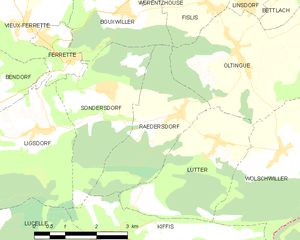
Редерсдорф
- коммуна во Франции
Hiking in Редерсдорф
Raedersdorf is a small village located in the Alsace region of France, not far from the German border. It offers a serene environment perfect for hiking enthusiasts who want to explore the scenic beauty of the area. Here are some details and tips for hiking in and around Raedersdorf:...
- Страна:
- Почтовый код: 68480
- Координаты: 47° 28' 30" N, 7° 22' 0" E
- GPS треки (wikiloc): [Ссылка]
- Площадь: 7.39 кв.км
- Население: 506

Бидертал
- коммуна во Франции
Hiking in Бидертал
Biederthal is a picturesque area in the Vosges mountains of France, known for its beautiful landscapes, lush forests, and serene hiking trails. The region offers various hiking opportunities suitable for different skill levels, from easy strolls to challenging treks....
- Страна:
- Почтовый код: 68480
- Координаты: 47° 28' 11" N, 7° 26' 55" E
- GPS треки (wikiloc): [Ссылка]
- Площадь: 4.16 кв.км
- Население: 302


Буксвиллер
- коммуна во Франции
Hiking in Буксвиллер
Bouxwiller is a charming village located in the Haut-Rhin department of France, known for its beautiful landscapes and scenic hiking opportunities. The region offers a variety of trails that cater to different skill levels, making it suitable for both beginner and experienced hikers....
- Страна:
- Почтовый код: 68480
- Координаты: 47° 30' 18" N, 7° 20' 45" E
- GPS треки (wikiloc): [Ссылка]
- Площадь: 6.47 кв.км
- Население: 463

Фислис
- коммуна во Франции
Hiking in Фислис
Fislis is not a well-documented hiking destination, so it's possible you might be referring to a specific area, trail, or region that goes by a similar name. However, if you're looking for hiking information in a general context, here's what you can consider if you’re exploring a typical hiking geography:...
- Страна:
- Почтовый код: 68480
- Координаты: 47° 30' 16" N, 7° 22' 54" E
- GPS треки (wikiloc): [Ссылка]
- Площадь: 7.53 кв.км
- Население: 423
- Веб сайт: [Ссылка]

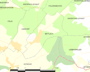
Бетлак
- коммуна во Франции
Hiking in Бетлак
Bettlach is a charming commune located in the Haut-Rhin department in the Grand Est region of France. While it may be a smaller and less known area compared to some larger hiking destinations, the surrounding region offers beautiful landscapes, scenic views, and a variety of outdoor activities....
- Страна:
- Почтовый код: 68480
- Координаты: 47° 30' 32" N, 7° 24' 51" E
- GPS треки (wikiloc): [Ссылка]
- Площадь: 4.09 кв.км
- Население: 308

Вольшвиллер
- коммуна во Франции
Hiking in Вольшвиллер
Wolschwiller is a charming village located in the Alsace region of France, near the border with Switzerland. The area is known for its beautiful natural scenery, making it a delightful destination for hikers. Here are some key points about hiking in and around Wolschwiller:...
- Страна:
- Почтовый код: 68480
- Координаты: 47° 27' 41" N, 7° 24' 29" E
- GPS треки (wikiloc): [Ссылка]
- Площадь: 10.14 кв.км
- Население: 469