Фислис (Fislis, Fislis)

- коммуна во Франции
 Hiking in Фислис
Fislis is not a well-documented hiking destination, so it's possible you might be referring to a specific area, trail, or region that goes by a similar name. However, if you're looking for hiking information in a general context, here's what you can consider if you’re exploring a typical hiking geography:
-
Trail Information: Research available trails in the area. Look for maps or trail websites that can provide details on trail length, elevation gain, difficulty level, and scenic highlights.
-
Best Seasons: Depending on the location and climate, the best times for hiking can vary. Generally, spring and fall offer milder temperatures and beautiful scenery with blooming wildflowers or autumn foliage.
-
Equipment: Ensure you have the right gear, including proper footwear, weather-appropriate clothing, a backpack with water, snacks, a first-aid kit, and navigation tools.
-
Local Wildlife: Familiarize yourself with local wildlife and plants. Knowing what to expect can enhance your experience and also prepare you for any encounters.
-
Safety Considerations: Always check weather conditions before heading out, inform someone about your hiking plans, and carry a map or GPS.
-
Leave No Trace: Follow the principles of Leave No Trace to minimize your impact on the environment and preserve the area for future hikers.
If you can provide more context or specify the location, I'm here to help with more tailored information!
- Страна:

- Почтовый код: 68480
- Координаты: 47° 30' 16" N, 7° 22' 54" E


- GPS треки (wikiloc): [Ссылка]
- Площадь: 7.53 кв.км
- Население: 423
- Веб сайт: http://www.fislis.fr/
- Википедия русская: wiki(ru)
- Википедия английская: wiki(en)
- Википедия национальная: wiki(fr)
- Хранилище Wikidata: Wikidata: Q392025
- Катеория в википедии: [Ссылка]
- код Freebase: [/m/03nsscc]
- код Freebase: [/m/03nsscc]
- код Freebase: [/m/03nsscc]
- код GeoNames: Альт: [6450704]
- код GeoNames: Альт: [6450704]
- код GeoNames: Альт: [6450704]
- номер SIREN: [216800920]
- номер SIREN: [216800920]
- номер SIREN: [216800920]
- код BNF: [152717940]
- код BNF: [152717940]
- код BNF: [152717940]
- код VIAF: Альт: [238812441]
- код VIAF: Альт: [238812441]
- код VIAF: Альт: [238812441]
- код муниципалитета INSEE: 68092
- код муниципалитета INSEE: 68092
- код муниципалитета INSEE: 68092
Граничит с регионами:

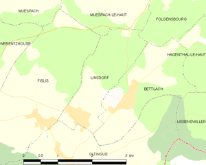
Линсдорф
- коммуна во Франции
Hiking in Линсдорф
Linsdorf isn't widely known as a major hiking destination, which suggests it may be a smaller or less commercialized area. If Linsdorf is a rural region or a small village, it may offer some local trails suitable for hiking, often featuring picturesque landscapes, natural beauty, and potential wildlife sightings....
- Страна:
- Почтовый код: 68480
- Координаты: 47° 30' 18" N, 7° 23' 49" E
- GPS треки (wikiloc): [Ссылка]
- Площадь: 3.36 кв.км
- Население: 317


Ольтен
- коммуна во Франции
Hiking in Ольтен
Oltingue is a small commune located in the Haut-Rhin department of eastern France, near the border with Switzerland. Hiking in this area can be quite rewarding, as it offers beautiful landscapes and the chance to experience the unique flora and fauna of the region....
- Страна:
- Почтовый код: 68480
- Координаты: 47° 29' 29" N, 7° 23' 30" E
- GPS треки (wikiloc): [Ссылка]
- Площадь: 13.42 кв.км
- Население: 721
- Веб сайт: [Ссылка]


Мюспак-ле-О
- коммуна во Франции
Hiking in Мюспак-ле-О
Muespach-le-Haut is a charming commune in the Haut-Rhin department of Alsace, in northeastern France. The area is known for its picturesque landscapes, rolling hills, and rich natural surroundings, making it a great destination for hiking enthusiasts....
- Страна:
- Почтовый код: 68640
- Координаты: 47° 32' 42" N, 7° 24' 11" E
- GPS треки (wikiloc): [Ссылка]
- Площадь: 6.91 кв.км
- Население: 1089
- Веб сайт: [Ссылка]

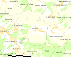
Мюспак
- коммуна во Франции
Hiking in Мюспак
Muespach is a charming village located in the Alsace region of France, close to the border with Switzerland. This picturesque area offers several hiking opportunities for various skill levels, and the surrounding nature is known for its stunning landscapes, lush forests, and rolling hills....
- Страна:
- Почтовый код: 68640
- Координаты: 47° 32' 51" N, 7° 22' 50" E
- GPS треки (wikiloc): [Ссылка]
- Высота над уровнем моря: 400 м m
- Площадь: 11.37 кв.км
- Население: 873
- Веб сайт: [Ссылка]


Буксвиллер
- коммуна во Франции
Hiking in Буксвиллер
Bouxwiller is a charming village located in the Haut-Rhin department of France, known for its beautiful landscapes and scenic hiking opportunities. The region offers a variety of trails that cater to different skill levels, making it suitable for both beginner and experienced hikers....
- Страна:
- Почтовый код: 68480
- Координаты: 47° 30' 18" N, 7° 20' 45" E
- GPS треки (wikiloc): [Ссылка]
- Площадь: 6.47 кв.км
- Население: 463

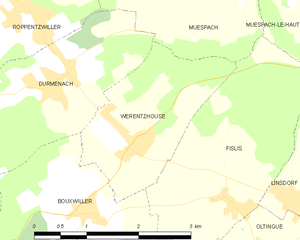
Верентсуз
- коммуна во Франции
Hiking in Верентсуз
Werentzhouse, located in the Alsace region of France, is not a widely known hiking destination, but the surrounding area offers beautiful landscapes and opportunities for outdoor activities. The region is characterized by its rolling hills, vineyards, and picturesque villages, making it a lovely place to explore on foot. Here are some key points to consider when hiking in and around Werentzhouse:...
- Страна:
- Почтовый код: 68480
- Координаты: 47° 31' 1" N, 7° 21' 27" E
- GPS треки (wikiloc): [Ссылка]
- Площадь: 4.5 кв.км
- Население: 560