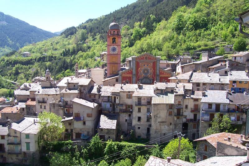
Брига-Альта (Briga Alta, Briga Alta)
- коммуна Италии
 Hiking in Брига-Альта
Briga Alta is a charming town located in the Piedmont region of northern Italy, known for its beautiful landscapes, historical significance, and excellent hiking opportunities. If you're considering hiking in that area, here are some details to keep in mind:
Hiking Trails
-
Valle Vigezzo: Known as the "Valley of the Painters," this area has several well-marked trails that offer stunning views of the valley and surrounding mountains. The trails vary in difficulty, catering to both beginners and experienced hikers.
-
Monte Gennaro: This is a popular hike for those looking for a moderate challenge. The summit provides panoramic views of the surrounding Alps and is an excellent spot for photography.
-
Sentiero del Meriggio: This trail is known for its scenic beauty and is suitable for families. It meanders through lush forests and leads to picturesque spots along the way.
-
Nature Reserves: The region is home to various nature reserves, where you can explore diverse flora and fauna. Wildlife enthusiasts will particularly enjoy the chance to see local animals in their natural habitats.
Best Time to Hike
The best time for hiking in Briga Alta is typically from late spring through early autumn (May to September). During these months, the weather is generally mild and the trails are in good condition. Be prepared for rain or sudden weather changes, especially in the early and late hiking seasons.
Preparation
- Gear: Make sure to wear appropriate hiking boots and carry a daypack with water, snacks, a first-aid kit, sunscreen, and a map or GPS.
- Local Regulations: Always check local regulations regarding trail access, especially in protected areas. Some locations may have restrictions or require permits.
- Guided Tours: If you’re not familiar with the area, consider joining a guided hike. Local guides can enhance your experience by providing insights into the region’s flora, fauna, and history.
Safety Tips
- Always inform someone about your hiking plans and expected return time.
- Stay on marked trails to protect the local ecosystem.
- Carry a charged mobile phone for emergencies but be aware that reception can be spotty in remote areas.
Enjoy your hiking experience in Briga Alta, surrounded by its natural beauty and rich culture!
- Страна:

- Почтовый код: 18025
- Телефонный код: 0174
- Код автомобильного номера: CN
- Координаты: 44° 4' 53" N, 7° 44' 27" E


- GPS треки (wikiloc): [Ссылка]
- Высота над уровнем моря: 1310 м m
- Площадь: 52.18 кв.км
- Население: 40
- Веб сайт: http://www.comune.brigaalta.cn.it
- Википедия русская: wiki(ru)
- Википедия английская: wiki(en)
- Википедия национальная: wiki(it)
- Хранилище Wikidata: Wikidata: Q18385
- Катеория в википедии: [Ссылка]
- код Freebase: [/m/0gb86t]
- код GeoNames: Альт: [6542422]
- код VIAF: Альт: [234768904]
- ID отношения в OpenStreetMap: [42844]
- код ISTAT: 004031
- кадастровый код Италии: B175
Граничит с регионами:

Кьюза-ди-Пезио
- коммуна Италии
Hiking in Кьюза-ди-Пезио
Chiusa di Pesio is a beautiful area located in the Piedmont region of Italy, renowned for its stunning natural landscapes and excellent hiking opportunities. Nestled in the heart of the Maritime Alps, Chiusa di Pesio offers a variety of trails that cater to different skill levels, making it an appealing destination for both casual walkers and experienced hikers....
- Страна:
- Почтовый код: 12013
- Телефонный код: 0171
- Код автомобильного номера: CN
- Координаты: 44° 19' 0" N, 7° 41' 0" E
- GPS треки (wikiloc): [Ссылка]
- Высота над уровнем моря: 575 м m
- Площадь: 95.02 кв.км
- Население: 3653
- Веб сайт: [Ссылка]

Лимоне-Пьемонте
- коммуна Италии
Hiking in Лимоне-Пьемонте
Limone Piemonte is a charming alpine resort located in the Piedmont region of Italy, nestled in the Maritime Alps, near the border with France. It offers a range of hiking opportunities that cater to different skill levels, from casual walks to more challenging treks. Here are some key highlights about hiking in Limone Piemonte:...
- Страна:
- Почтовый код: 12015
- Телефонный код: 0171
- Код автомобильного номера: CN
- Координаты: 44° 12' 0" N, 7° 34' 0" E
- GPS треки (wikiloc): [Ссылка]
- Высота над уровнем моря: 1010 м m
- Площадь: 70.81 кв.км
- Население: 1466
- Веб сайт: [Ссылка]

Ормеа
- коммуна Италии
Hiking in Ормеа
Ormea, located in the Liguria region of Italy, is a hidden gem for hiking enthusiasts. Nestled in the Maritime Alps, this charming town offers breathtaking landscapes, rich biodiversity, and a variety of trails suitable for all experience levels. Here are some key points about hiking in and around Ormea:...
- Страна:
- Почтовый код: 12078
- Телефонный код: 0174
- Код автомобильного номера: CN
- Координаты: 44° 9' 0" N, 7° 55' 0" E
- GPS треки (wikiloc): [Ссылка]
- Высота над уровнем моря: 740 м m
- Площадь: 124.5 кв.км
- Население: 1607
- Веб сайт: [Ссылка]

Роккафорте-Мондови
- коммуна Италии
Hiking in Роккафорте-Мондови
Roccaforte Mondovì is a charming village nestled in the Piedmont region of Italy, surrounded by the stunning landscape of the Maritime Alps. This area is known for its diverse hiking opportunities, offering trails for various skill levels and preferences. Here are some highlights and tips for hiking in Roccaforte Mondovì:...
- Страна:
- Почтовый код: 12088
- Телефонный код: 0174
- Код автомобильного номера: CN
- Координаты: 44° 19' 0" N, 7° 45' 0" E
- GPS треки (wikiloc): [Ссылка]
- Высота над уровнем моря: 574 м m
- Площадь: 84.61 кв.км
- Население: 2140
- Веб сайт: [Ссылка]

Тенд
- коммуна в департаменте Приморские Альпы, регион Прованс — Альпы — Лазурный Берег, Франция
Hiking in Тенд
Tende is a picturesque commune located in the Alpes-Maritimes department in the Provence-Alpes-Côte d'Azur region of southeastern France. Nestled in the Maritime Alps, it's an excellent destination for hiking enthusiasts, offering stunning landscapes, varied terrains, and rich natural and cultural heritage....
- Страна:

- Почтовый код: 06430
- Координаты: 44° 5' 16" N, 7° 35' 37" E
- GPS треки (wikiloc): [Ссылка]
- Высота над уровнем моря: 816 м m
- Площадь: 177.47 кв.км
- Население: 2174
- Веб сайт: [Ссылка]


Козио-ди-Аррошия
- коммуна Италии
Hiking in Козио-ди-Аррошия
Cosio di Arroscia is a picturesque village located in the province of Imperia, in the Liguria region of Italy. It’s nestled in the Arroscia Valley and is surrounded by beautiful natural landscapes, making it a great spot for hiking enthusiasts seeking serene trails and stunning views....
- Страна:
- Почтовый код: 18023
- Телефонный код: 0183
- Код автомобильного номера: IM
- Координаты: 44° 4' 32" N, 7° 49' 52" E
- GPS треки (wikiloc): [Ссылка]
- Высота над уровнем моря: 721 м m
- Площадь: 40.56 кв.км
- Население: 204
- Веб сайт: [Ссылка]


Мендатика
- коммуна Италии
Hiking in Мендатика
Mendatica is a charming village in the Ligurian region of Italy, known for its picturesque landscapes and rich natural beauty, making it an excellent destination for hiking enthusiasts. The area is characterized by rugged mountains, dense forests, and scenic valleys, providing a variety of trails suitable for different skill levels....
- Страна:
- Почтовый код: 18025
- Телефонный код: 0183
- Код автомобильного номера: IM
- Координаты: 44° 4' 35" N, 7° 48' 20" E
- GPS треки (wikiloc): [Ссылка]
- Высота над уровнем моря: 778 м m
- Площадь: 30.69 кв.км
- Население: 187
- Веб сайт: [Ссылка]


Триора
- коммуна Италии
Hiking in Триора
Triora is a picturesque village located in the Italian region of Liguria, known for its stunning landscapes and rich history. Nestled in the mountains, it's an excellent destination for hiking enthusiasts....
- Страна:
- Почтовый код: 18010
- Телефонный код: 0184
- Код автомобильного номера: IM
- Координаты: 44° 0' 0" N, 7° 46' 0" E
- GPS треки (wikiloc): [Ссылка]
- Высота над уровнем моря: 780 м m
- Площадь: 68 кв.км
- Население: 361
- Веб сайт: [Ссылка]


Ла-Бриг
- коммуна в департаменте Приморские Альпы, регион Прованс — Альпы — Лазурный Берег, Франция
Hiking in Ла-Бриг
La Brigue is a beautiful commune in the Alpes-Maritimes department of southeastern France, located near the Italian border. Nestled in the Mercantour National Park, it offers stunning landscapes, diverse flora and fauna, and various hiking trails suitable for all levels of hikers. Here are some highlights about hiking in La Brigue:...
- Страна:
- Почтовый код: 06430
- Координаты: 44° 3' 45" N, 7° 36' 59" E
- GPS треки (wikiloc): [Ссылка]
- Высота над уровнем моря: 748 м m
- Площадь: 91.77 кв.км
- Население: 706
- Веб сайт: [Ссылка]