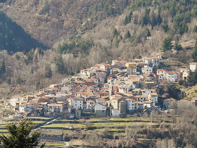
Триора (Triora, Triora)
.svg)
- коммуна Италии
 Hiking in Триора
Triora is a picturesque village located in the Italian region of Liguria, known for its stunning landscapes and rich history. Nestled in the mountains, it's an excellent destination for hiking enthusiasts.
Hiking Trails in Triora
-
Rondini Trail:
- Distance: Approximately 8 km
- Difficulty: Moderate
- Description: This trail winds through dense forests and offers breathtaking views of the surrounding valleys. You'll encounter beautiful wildflowers in the spring and scenic vistas, making it a perfect trail for photography lovers.
-
Path of the Witch (Sentiero delle Streghe):
- Distance: Varied, can be tailored to fit desired length
- Difficulty: Moderate
- Description: The trail takes you through the heart of Triora’s witchcraft history, showcasing historical landmarks and informative signs about the area's witch trials. You’ll also enjoy lovely views of the surrounding mountains.
-
Monte Ceppo Trail:
- Distance: About 12 km
- Difficulty: Challenging
- Description: This hike ascends to Monte Ceppo, one of the peaks that offer panoramic views of the entire area. This trail is suited for more experienced hikers, with steep sections and rocky paths.
Best Time to Hike
- Spring (March to May) and Autumn (September to November) are the best times for hiking around Triora. The weather is milder, and the trails are less crowded compared to the summer months.
Tips for Hiking in Triora
- Wear proper footwear: Good hiking boots are essential for navigating rocky and uneven terrain.
- Bring water and snacks: Stay hydrated and keep your energy levels up, especially on longer hikes.
- Check weather conditions: Mountain weather can change rapidly, so it's wise to check the forecast before heading out.
- Respect local wildlife: Keep a safe distance from animals and do not disturb natural habitats.
Local Culture
After your hike, take time to explore Triora itself. Known for its medieval architecture, narrow streets, and historical significance, it also offers local cuisine that reflects its Ligurian roots. Don't miss trying some of the region's specialties, like trofie pasta with pesto or focaccia.
Hiking in Triora offers a unique blend of natural beauty and cultural richness, making it a memorable experience for outdoor enthusiasts. Enjoy your adventure!
- Страна:

- Почтовый код: 18010
- Телефонный код: 0184
- Код автомобильного номера: IM
- Координаты: 44° 0' 0" N, 7° 46' 0" E


- GPS треки (wikiloc): [Ссылка]
- Высота над уровнем моря: 780 м m
- Площадь: 68 кв.км
- Население: 361
- Веб сайт: http://www.comune.triora.im.it
- Википедия русская: wiki(ru)
- Википедия английская: wiki(en)
- Википедия национальная: wiki(it)
- Хранилище Wikidata: Wikidata: Q269831
- Галерея изображений в википедии: [Ссылка]
- Катеория в википедии: [Ссылка]
- код Freebase: [/m/0gbz7f]
- код GeoNames: Альт: [6540319]
- код VIAF: Альт: [147029266]
- ID отношения в OpenStreetMap: [42778]
- WOEID: [725313]
- код ISTAT: 008061
- кадастровый код Италии: L430
Граничит с регионами:

Брига-Альта
- коммуна Италии
Hiking in Брига-Альта
Briga Alta is a charming town located in the Piedmont region of northern Italy, known for its beautiful landscapes, historical significance, and excellent hiking opportunities. If you're considering hiking in that area, here are some details to keep in mind:...
- Страна:
- Почтовый код: 18025
- Телефонный код: 0174
- Код автомобильного номера: CN
- Координаты: 44° 4' 53" N, 7° 44' 27" E
- GPS треки (wikiloc): [Ссылка]
- Высота над уровнем моря: 1310 м m
- Площадь: 52.18 кв.км
- Население: 40
- Веб сайт: [Ссылка]


Кастель-Витторио
- коммуна Италии
Hiking in Кастель-Витторио
Castel Vittorio, a charming medieval village located in the Italian region of Liguria, is nestled in the scenic hills of the Nervia Valley. Hiking in this area offers a mix of natural beauty, cultural heritage, and various trails suitable for different skill levels....
- Страна:
- Почтовый код: 18030
- Телефонный код: 0184
- Код автомобильного номера: IM
- Координаты: 43° 55' 40" N, 7° 40' 27" E
- GPS треки (wikiloc): [Ссылка]
- Высота над уровнем моря: 420 м m
- Площадь: 25.93 кв.км
- Население: 288
- Веб сайт: [Ссылка]


Мендатика
- коммуна Италии
Hiking in Мендатика
Mendatica is a charming village in the Ligurian region of Italy, known for its picturesque landscapes and rich natural beauty, making it an excellent destination for hiking enthusiasts. The area is characterized by rugged mountains, dense forests, and scenic valleys, providing a variety of trails suitable for different skill levels....
- Страна:
- Почтовый код: 18025
- Телефонный код: 0183
- Код автомобильного номера: IM
- Координаты: 44° 4' 35" N, 7° 48' 20" E
- GPS треки (wikiloc): [Ссылка]
- Высота над уровнем моря: 778 м m
- Площадь: 30.69 кв.км
- Население: 187
- Веб сайт: [Ссылка]


Молини-ди-Трьора
- коммуна Италии
Hiking in Молини-ди-Трьора
Molini di Triora is a picturesque village located in the Liguria region of Italy, nestled in the mountains of the Impero Valley. This area is rich in natural beauty, historical significance, and offers plenty of hiking opportunities for enthusiasts....
- Страна:
- Почтовый код: 18010
- Телефонный код: 0184
- Код автомобильного номера: IM
- Координаты: 43° 59' 25" N, 7° 46' 29" E
- GPS треки (wikiloc): [Ссылка]
- Высота над уровнем моря: 460 м m
- Площадь: 58.05 кв.км
- Население: 604
- Веб сайт: [Ссылка]

Монтегроссо-Пьян-Латте
- коммуна Италии
Hiking in Монтегроссо-Пьян-Латте
Montegrosso Pian Latte is a charming village located in the province of Imperia, in the Italian Liguria region. Nestled in the foothills of the Alps, it offers an array of stunning landscapes, rich biodiversity, and various hiking trails suitable for different skill levels. Here are some key points to consider if you're planning to hike in Montegrosso Pian Latte:...
- Страна:
- Почтовый код: 18025
- Телефонный код: 0183
- Код автомобильного номера: IM
- Координаты: 44° 4' 0" N, 7° 49' 4" E
- GPS треки (wikiloc): [Ссылка]
- Высота над уровнем моря: 721 м m
- Площадь: 10.03 кв.км
- Население: 124
- Веб сайт: [Ссылка]


Пинья
- коммуна Италии
Hiking in Пинья
Pigna, a picturesque village in the Italian region of Liguria, offers a wonderful hiking experience characterized by its enchanting landscapes, olive groves, and stunning views of the surrounding mountains and valleys. Here are some key points to consider when planning a hiking trip to Pigna:...
- Страна:
- Почтовый код: 18037
- Телефонный код: 0184
- Код автомобильного номера: IM
- Координаты: 43° 55' 57" N, 7° 39' 50" E
- GPS треки (wikiloc): [Ссылка]
- Высота над уровнем моря: 280 м m
- Площадь: 53.23 кв.км
- Население: 843
- Веб сайт: [Ссылка]


Ла-Бриг
- коммуна в департаменте Приморские Альпы, регион Прованс — Альпы — Лазурный Берег, Франция
Hiking in Ла-Бриг
La Brigue is a beautiful commune in the Alpes-Maritimes department of southeastern France, located near the Italian border. Nestled in the Mercantour National Park, it offers stunning landscapes, diverse flora and fauna, and various hiking trails suitable for all levels of hikers. Here are some highlights about hiking in La Brigue:...
- Страна:

- Почтовый код: 06430
- Координаты: 44° 3' 45" N, 7° 36' 59" E
- GPS треки (wikiloc): [Ссылка]
- Высота над уровнем моря: 748 м m
- Площадь: 91.77 кв.км
- Население: 706
- Веб сайт: [Ссылка]
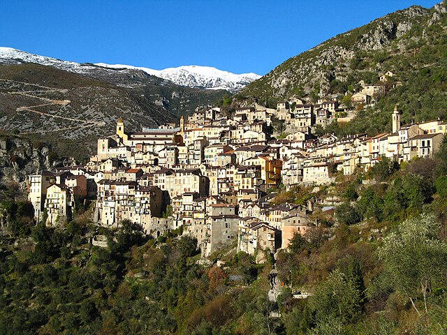

Саорж
- коммуна в департаменте Приморские Альпы, регион Прованс — Альпы — Лазурный Берег, Франция
Hiking in Саорж
Saorge is a picturesque village located in the Alpes-Maritimes region of France, not far from the Italian border. The area is known for its stunning landscapes, charming architecture, and an array of hiking opportunities that cater to different skill levels. Here are some highlights and trails to consider when hiking in and around Saorge:...
- Страна:
- Почтовый код: 06540
- Координаты: 43° 59' 14" N, 7° 33' 9" E
- GPS треки (wikiloc): [Ссылка]
- Высота над уровнем моря: 513 м m
- Площадь: 86.78 кв.км
- Население: 455
- Веб сайт: [Ссылка]