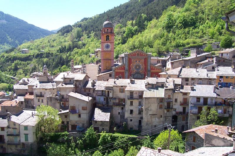
Ла-Бриг (La Brigue, La Brigue)

- коммуна в департаменте Приморские Альпы, регион Прованс — Альпы — Лазурный Берег, Франция
 Hiking in Ла-Бриг
La Brigue is a beautiful commune in the Alpes-Maritimes department of southeastern France, located near the Italian border. Nestled in the Mercantour National Park, it offers stunning landscapes, diverse flora and fauna, and various hiking trails suitable for all levels of hikers. Here are some highlights about hiking in La Brigue:
Trails and Routes
-
Sentier des Granges: This trail takes you through picturesque pastures and traditional mountain villages, offering breathtaking views of the surrounding mountains.
-
Col de Fenestre: A well-known route that leads to the Col de Fenestre, providing panoramic views and access to higher altitude trails. Ideal for those looking to experience the beauty of the Mercantour National Park.
-
Gorges de la Brigue: A more challenging hike, this trail showcases spectacular gorges and waterfalls, perfect for experienced hikers looking for adventure.
-
Lacs de Merveilles: This longer trek leads to stunning glacial lakes in the heart of the park, featuring incredible scenery and the opportunity to see ancient rock carvings.
What to Expect
- Scenic Views: La Brigue is known for its striking landscapes, including rugged mountains, lush valleys, and serene lakes.
- Wildlife: The area is home to diverse wildlife, including ibex, chamois, and a variety of bird species.
- Flora: Hikers can enjoy an array of plant life ranging from alpine meadows to dense forests.
- Historical Sites: There are several ancient villages and ruins along the trails that offer insight into the region’s history.
Best Time to Hike
- Spring and Fall: Late spring (May to June) and early fall (September to October) are ideal times for hiking, as the weather is generally mild and the trails are less crowded.
- Summer: Though summer is popular for hiking, it can be warm. Prepare for potential afternoon storms in the mountains.
Preparation Tips
- Gear: Wear sturdy hiking boots, bring a reliable map or GPS, and carry sufficient water and snacks.
- Weather: Be prepared for changing weather conditions, especially at higher altitudes—layers are recommended.
- Local Regulations: Always check local regulations and trail conditions before heading out, especially in national parks.
Accessibility
La Brigue is accessible by train and bus from major cities in the region, making it relatively easy to reach for a weekend hiking trip. Local accommodations range from guesthouses to campsites, providing options for various budgets.
Whether you’re an experienced hiker or just looking to enjoy a leisurely walk in nature, La Brigue offers a range of options that showcase the beauty and tranquility of the French Alps.
- Страна:

- Почтовый код: 06430
- Координаты: 44° 3' 45" N, 7° 36' 59" E


- GPS треки (wikiloc): [Ссылка]
- Высота над уровнем моря: 748 м m
- Площадь: 91.77 кв.км
- Население: 706
- Веб сайт: http://www.labrigue.fr
- Википедия русская: wiki(ru)
- Википедия английская: wiki(en)
- Википедия национальная: wiki(fr)
- Хранилище Wikidata: Wikidata: Q387498
- Катеория в википедии: [Ссылка]
- код Freebase: [/m/03m4yph]
- код Freebase: [/m/03m4yph]
- код GeoNames: Альт: [3010789]
- код GeoNames: Альт: [3010789]
- номер SIREN: [210601621]
- номер SIREN: [210601621]
- код VIAF: Альт: [310520270]
- код VIAF: Альт: [310520270]
- код LCNAF: Альт: [n94121024]
- код LCNAF: Альт: [n94121024]
- код муниципалитета INSEE: 06162
- код муниципалитета INSEE: 06162
Граничит с регионами:

Брига-Альта
- коммуна Италии
Hiking in Брига-Альта
Briga Alta is a charming town located in the Piedmont region of northern Italy, known for its beautiful landscapes, historical significance, and excellent hiking opportunities. If you're considering hiking in that area, here are some details to keep in mind:...
- Страна:

- Почтовый код: 18025
- Телефонный код: 0174
- Код автомобильного номера: CN
- Координаты: 44° 4' 53" N, 7° 44' 27" E
- GPS треки (wikiloc): [Ссылка]
- Высота над уровнем моря: 1310 м m
- Площадь: 52.18 кв.км
- Население: 40
- Веб сайт: [Ссылка]

Кьюза-ди-Пезио
- коммуна Италии
Hiking in Кьюза-ди-Пезио
Chiusa di Pesio is a beautiful area located in the Piedmont region of Italy, renowned for its stunning natural landscapes and excellent hiking opportunities. Nestled in the heart of the Maritime Alps, Chiusa di Pesio offers a variety of trails that cater to different skill levels, making it an appealing destination for both casual walkers and experienced hikers....
- Страна:
- Почтовый код: 12013
- Телефонный код: 0171
- Код автомобильного номера: CN
- Координаты: 44° 19' 0" N, 7° 41' 0" E
- GPS треки (wikiloc): [Ссылка]
- Высота над уровнем моря: 575 м m
- Площадь: 95.02 кв.км
- Население: 3653
- Веб сайт: [Ссылка]

Энтраккуе
- коммуна Италии
Hiking in Энтраккуе
Entracque is a picturesque village located in the Piedmont region of Italy, nestled in the stunning Maritime Alps. It's an excellent destination for hiking enthusiasts, offering a range of trails that cater to various skill levels, from beginners to advanced hikers. Here are some highlights of hiking in Entracque:...
- Страна:
- Почтовый код: 12010
- Телефонный код: 0171
- Код автомобильного номера: CN
- Координаты: 44° 14' 33" N, 7° 24' 0" E
- GPS треки (wikiloc): [Ссылка]
- Высота над уровнем моря: 894 м m
- Площадь: 160.73 кв.км
- Население: 848
- Веб сайт: [Ссылка]

Лимоне-Пьемонте
- коммуна Италии
Hiking in Лимоне-Пьемонте
Limone Piemonte is a charming alpine resort located in the Piedmont region of Italy, nestled in the Maritime Alps, near the border with France. It offers a range of hiking opportunities that cater to different skill levels, from casual walks to more challenging treks. Here are some key highlights about hiking in Limone Piemonte:...
- Страна:
- Почтовый код: 12015
- Телефонный код: 0171
- Код автомобильного номера: CN
- Координаты: 44° 12' 0" N, 7° 34' 0" E
- GPS треки (wikiloc): [Ссылка]
- Высота над уровнем моря: 1010 м m
- Площадь: 70.81 кв.км
- Население: 1466
- Веб сайт: [Ссылка]

Тенд
- коммуна в департаменте Приморские Альпы, регион Прованс — Альпы — Лазурный Берег, Франция
Hiking in Тенд
Tende is a picturesque commune located in the Alpes-Maritimes department in the Provence-Alpes-Côte d'Azur region of southeastern France. Nestled in the Maritime Alps, it's an excellent destination for hiking enthusiasts, offering stunning landscapes, varied terrains, and rich natural and cultural heritage....
- Страна:
- Почтовый код: 06430
- Координаты: 44° 5' 16" N, 7° 35' 37" E
- GPS треки (wikiloc): [Ссылка]
- Высота над уровнем моря: 816 м m
- Площадь: 177.47 кв.км
- Население: 2174
- Веб сайт: [Ссылка]


Триора
- коммуна Италии
Hiking in Триора
Triora is a picturesque village located in the Italian region of Liguria, known for its stunning landscapes and rich history. Nestled in the mountains, it's an excellent destination for hiking enthusiasts....
- Страна:
- Почтовый код: 18010
- Телефонный код: 0184
- Код автомобильного номера: IM
- Координаты: 44° 0' 0" N, 7° 46' 0" E
- GPS треки (wikiloc): [Ссылка]
- Высота над уровнем моря: 780 м m
- Площадь: 68 кв.км
- Население: 361
- Веб сайт: [Ссылка]


Фонтан
- коммуна в департаменте Приморские Альпы, регион Прованс — Альпы — Лазурный Берег, Франция
Hiking in Фонтан
Fontan is a small village located in the Alpes-Maritimes department in southeastern France. Nestled in the mountains, it offers a variety of scenic hiking opportunities for outdoor enthusiasts. Here are some highlights and tips for hiking in and around Fontan:...
- Страна:
- Почтовый код: 06540
- Координаты: 44° 0' 14" N, 7° 33' 13" E
- GPS треки (wikiloc): [Ссылка]
- Площадь: 49.61 кв.км
- Население: 352
- Веб сайт: [Ссылка]
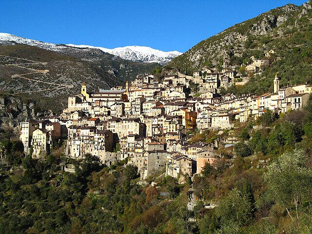

Саорж
- коммуна в департаменте Приморские Альпы, регион Прованс — Альпы — Лазурный Берег, Франция
Hiking in Саорж
Saorge is a picturesque village located in the Alpes-Maritimes region of France, not far from the Italian border. The area is known for its stunning landscapes, charming architecture, and an array of hiking opportunities that cater to different skill levels. Here are some highlights and trails to consider when hiking in and around Saorge:...
- Страна:
- Почтовый код: 06540
- Координаты: 43° 59' 14" N, 7° 33' 9" E
- GPS треки (wikiloc): [Ссылка]
- Высота над уровнем моря: 513 м m
- Площадь: 86.78 кв.км
- Население: 455
- Веб сайт: [Ссылка]