Бюи-ле-Баронни (canton of Buis-les-Baronnies, canton de Buis-les-Baronnies)
 Hiking in Бюи-ле-Баронни
Canton de Buis-les-Baronnies, located in the Drôme department of the Auvergne-Rhône-Alpes region in southeastern France, is a fantastic destination for hiking enthusiasts. This picturesque area offers a variety of trails, stunning landscapes, and diverse ecosystems, making it suitable for both novice and experienced hikers.
Key Highlights:
-
Scenic Trails: The region features numerous well-marked hiking trails that lead through breathtaking scenery, including panoramic views of the Baronnies Mountains, olive groves, vineyards, and charming villages. One popular route is the trail that runs through the Gorges de la Méouge, known for its dramatic rock formations and clear waters.
-
Biodiversity: The area is part of the Baronnies Provençales Regional Natural Park, which is home to rich flora and fauna. Hikers can enjoy the diverse ecosystems, from Mediterranean scrubland to alpine meadows, and may encounter various wildlife, including birds, butterflies, and other native species.
-
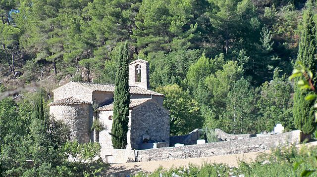
Cultural Sites: Many trails pass by local historical and cultural sites, such as ancient churches, remains of old fortifications, and traditional villages. Exploring these sites offers insight into the region’s history and culture.
-
Difficulty Levels: There are routes suitable for all fitness levels. Beginners can enjoy easier, flatter walks, while more experienced hikers can tackle challenging ascents and longer distances.
-
Local Gastronomy: After a day of hiking, consider enjoying local cuisine in one of the villages. Look for regional specialties like olive oil, goat cheese, and local wines.
-
Best Times to Visit: The best times for hiking in this region are spring (April to June) and fall (September to October) when the weather is generally mild and the landscapes are particularly beautiful.
Tips for Hiking:
- Maps and Guides: Always carry a detailed map or a hiking guide of the area, as well as a compass or GPS device.
- Prepare for Weather: The weather can change rapidly in mountain regions, so be prepared with appropriate clothing and gear.
- Stay Hydrated and Nourished: Carry enough water and snacks, especially for longer hikes.
- Respect Nature: Follow Leave No Trace principles to protect the natural environment.
Overall, hiking in Canton de Buis-les-Baronnies offers a serene escape into nature along with opportunities to enjoy the region’s unique cultural heritage. Whether you are looking for a leisurely stroll or a more strenuous trek, this area has something for everyone.
- Страна:

- Столица: Buis-les-Baronnies
- Координаты: 44° 17' 1" N, 5° 17' 54" E


- GPS треки (wikiloc): [Ссылка]
- Хранилище Wikidata: Wikidata: Q1724648
- код кантона INSEE: [2603]
Включает регионы:


Mérindol-les-Oliviers
- коммуна во Франции
Hiking in Mérindol-les-Oliviers
Mérindol-les-Oliviers is a charming village located in the Vaucluse department of the Provence-Alpes-Côte d'Azur region in southeastern France. Surrounded by beautiful landscapes and vineyards, the area offers several opportunities for hiking enthusiasts. Here are some highlights about hiking in and around Mérindol-les-Oliviers:...
- Страна:
- Почтовый код: 26170
- Координаты: 44° 16' 27" N, 5° 10' 4" E
- GPS треки (wikiloc): [Ссылка]
- Площадь: 9.23 кв.км
- Население: 222
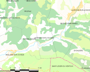
La Penne-sur-l'Ouvèze
- коммуна во Франции
Hiking in La Penne-sur-l'Ouvèze
La Penne-sur-l'Ouvèze is a charming village located in the Vaucluse department of the Provence-Alpes-Côte d'Azur region in southeastern France. It is a fantastic destination for hiking enthusiasts, as it offers a variety of trails that cater to different skill levels and showcase the beautiful natural landscape of the region. Here are some highlights of hiking in this area:...
- Страна:
- Почтовый код: 26170
- Координаты: 44° 15' 7" N, 5° 13' 42" E
- GPS треки (wikiloc): [Ссылка]
- Площадь: 7.32 кв.км
- Население: 102

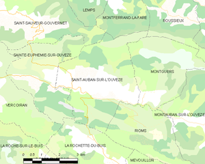
Сент-Обан-Сюр-л'Увез
- коммуна во Франции
Hiking in Сент-Обан-Сюр-л'Увез
Saint-Auban-sur-l'Ouvèze is a charming village located in the Drôme department in southeastern France, known for its picturesque landscapes and diverse hiking opportunities. Nestled in the Vercors Regional Natural Park, it offers a range of trails suitable for different skill levels, making it an excellent destination for hikers. Here are some key points to consider if you're planning a hiking trip there:...
- Страна:
- Почтовый код: 26170
- Координаты: 44° 17' 18" N, 5° 24' 59" E
- GPS треки (wikiloc): [Ссылка]
- Площадь: 16.55 кв.км
- Население: 216

La Rochette-du-Buis
- коммуна во Франции
Hiking in La Rochette-du-Buis
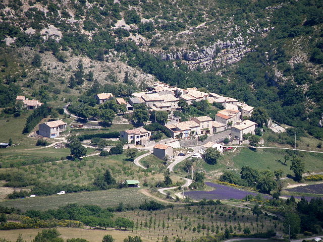
La Rochette-du-Buis is a picturesque village located in the Drôme department of France, part of the Auvergne-Rhône-Alpes region. It is surrounded by stunning natural landscapes, making it an ideal location for hiking enthusiasts....
- Страна:
- Почтовый код: 26170
- Координаты: 44° 16' 9" N, 5° 25' 13" E
- GPS треки (wikiloc): [Ссылка]
- Площадь: 10.36 кв.км
- Население: 78


La Roche-sur-le-Buis
- коммуна во Франции
Hiking in La Roche-sur-le-Buis
La Roche-sur-le-Buis is a charming commune located in the Vaucluse department of southeastern France, nestled in the scenic landscapes of the Drôme Provençale region. It’s a lesser-known destination for hikers, but it offers an array of beautiful trails and natural sites that are perfect for outdoor enthusiasts....
- Страна:
- Почтовый код: 26170
- Координаты: 44° 16' 37" N, 5° 18' 44" E
- GPS треки (wikiloc): [Ссылка]
- Площадь: 27.72 кв.км
- Население: 295

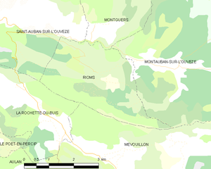
Rioms
- коммуна во Франции
Hiking in Rioms
Rioms is a picturesque destination in France known for its stunning landscapes and hiking opportunities. The area features a mix of rolling hills, forests, and scenic views, making it a great spot for both casual walkers and experienced hikers....
- Страна:
- Почтовый код: 26170
- Координаты: 44° 16' 24" N, 5° 27' 34" E
- GPS треки (wikiloc): [Ссылка]
- Площадь: 9.39 кв.км
- Население: 26

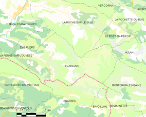
Plaisians
- коммуна во Франции
Hiking in Plaisians
Plaisians is a charming village located in the southern part of France, nestled in the picturesque region of the Vaucluse in Provence. It offers stunning landscapes, including rolling hills, vineyards, and forests, making it a fantastic destination for hiking enthusiasts....
- Страна:
- Почтовый код: 26170
- Координаты: 44° 13' 45" N, 5° 19' 3" E
- GPS треки (wikiloc): [Ссылка]
- Площадь: 29.64 кв.км
- Население: 195


Rochebrune
Hiking in Rochebrune
Rochebrune is a picturesque region located in the Drôme department of southeastern France, known for its stunning natural landscapes and diverse hiking opportunities. If you're planning to hike in Rochebrune, here are some key points to consider:...
- Страна:
- Почтовый код: 26110
- Координаты: 44° 20' 13" N, 5° 14' 44" E
- GPS треки (wikiloc): [Ссылка]
- Площадь: 16.15 кв.км
- Население: 61

Saint-Sauveur-Gouvernet
- коммуна во Франции
Hiking in Saint-Sauveur-Gouvernet
Saint-Sauveur-Gouvernet is a charming commune located in the Auvergne-Rhône-Alpes region of France. It is known for its beautiful natural surroundings, making it an excellent destination for hiking enthusiasts. Here are some highlights about hiking in and around Saint-Sauveur-Gouvernet:...
- Страна:
- Почтовый код: 26110
- Координаты: 44° 20' 14" N, 5° 21' 3" E
- GPS треки (wikiloc): [Ссылка]
- Площадь: 19.32 кв.км
- Население: 184


Vercoiran
- коммуна во Франции
Hiking in Vercoiran
Vercoiran is a charming commune located in the Drôme department in southeastern France, known for its beautiful natural landscapes and outdoor activities, including hiking. The region offers various trails that cater to different levels of hikers, from beginners to more experienced outdoor enthusiasts....
- Страна:
- Почтовый код: 26170
- Координаты: 44° 18' 3" N, 5° 20' 45" E
- GPS треки (wikiloc): [Ссылка]
- Площадь: 19.95 кв.км
- Население: 144


Buis-les-Baronnies
- коммуна во Франции
Hiking in Buis-les-Baronnies
Buis-les-Baronnies, located in the Drome department of southeastern France, is a fantastic destination for hiking enthusiasts. Nestled in the picturesque Baronnies region, the area boasts diverse landscapes, varying altitudes, and a mild Mediterranean climate, making it ideal for outdoor activities....
- Страна:
- Почтовый код: 26170
- Координаты: 44° 16' 31" N, 5° 16' 28" E
- GPS треки (wikiloc): [Ссылка]
- Площадь: 33.74 кв.км
- Население: 2287
- Веб сайт: [Ссылка]


Pierrelongue
- коммуна во Франции
Hiking in Pierrelongue
Pierrelongue, a charming village located in the Drôme department in southeastern France, is known for its beautiful natural landscapes and outdoor activities, including hiking. Here are some key points about hiking in and around Pierrelongue:...
- Страна:
- Почтовый код: 26170
- Координаты: 44° 14' 45" N, 5° 13' 4" E
- GPS треки (wikiloc): [Ссылка]
- Площадь: 5.13 кв.км
- Население: 229

Mollans-sur-Ouvèze
- коммуна во Франции
Hiking in Mollans-sur-Ouvèze
Mollans-sur-Ouvèze is a charming village located in the Vaucluse department in the Provence-Alpes-Côte d'Azur region of France. It is surrounded by picturesque landscapes, making it a great destination for hiking enthusiasts. Here are some key points about hiking in and around Mollans-sur-Ouvèze:...
- Страна:
- Почтовый код: 26170
- Координаты: 44° 14' 11" N, 5° 11' 27" E
- GPS треки (wikiloc): [Ссылка]
- Площадь: 19.96 кв.км
- Население: 1062


Propiac
- коммуна во Франции
Hiking in Propiac
Propiac is a charming village located in the Drôme department of the Auvergne-Rhône-Alpes region in southeastern France. It's situated near the picturesque landscapes of the Vercors Regional Natural Park, making it an excellent base for hiking enthusiasts. Here are some important points about hiking in and around Propiac:...
- Страна:
- Почтовый код: 26170
- Координаты: 44° 16' 40" N, 5° 11' 55" E
- GPS треки (wikiloc): [Ссылка]
- Площадь: 11.15 кв.км
- Население: 117


Bellecombe-Tarendol
- коммуна во Франции
Hiking in Bellecombe-Tarendol
Bellecombe-Tarendol is a picturesque area located in the Auvergne-Rhône-Alpes region of France, which offers a range of hiking opportunities for both novices and experienced hikers. Nestled in the foothills of the Alps, the region is known for its stunning natural beauty, including rolling hills, dense forests, and diverse wildlife....
- Страна:
- Почтовый код: 26110
- Координаты: 44° 21' 6" N, 5° 21' 11" E
- GPS треки (wikiloc): [Ссылка]
- Площадь: 13.48 кв.км
- Население: 86


Le Poët-en-Percip
- коммуна во Франции
Hiking in Le Poët-en-Percip
Le Poët-en-Percip is a charming village located in the Drôme region of southeastern France, surrounded by beautiful natural landscapes that are perfect for hiking. The area is characterized by rolling hills, forests, and stunning views of the surrounding valleys and mountains. Here are some key points to consider when hiking in Le Poët-en-Percip:...
- Страна:
- Почтовый код: 26170
- Координаты: 44° 15' 16" N, 5° 23' 32" E
- GPS треки (wikiloc): [Ссылка]
- Площадь: 6.07 кв.км
- Население: 18


Sainte-Euphémie-sur-Ouvèze
- коммуна во Франции
Hiking in Sainte-Euphémie-sur-Ouvèze
Sainte-Euphémie-sur-Ouvèze is a quaint village located in the Vaucluse department in the Provence-Alpes-Côte d'Azur region of southeastern France. Nestled within the picturesque landscape of the foothills of the Mont Ventoux, it offers a variety of hiking opportunities for outdoor enthusiasts....
- Страна:
- Почтовый код: 26170
- Координаты: 44° 18' 2" N, 5° 22' 46" E
- GPS треки (wikiloc): [Ссылка]
- Площадь: 11.28 кв.км
- Население: 72


Eygaliers
- коммуна во Франции
Hiking in Eygaliers
Eygaliers is a beautiful village located in the southern part of France, in the region of Provence-Alpes-Côte d'Azur, specifically in the Drôme department. This area is known for its stunning landscapes, including rocky cliffs, lush forests, and breathtaking views of the surrounding countryside, making it a fantastic destination for hiking enthusiasts....
- Страна:
- Почтовый код: 26170
- Координаты: 44° 14' 21" N, 5° 16' 48" E
- GPS треки (wikiloc): [Ссылка]
- Площадь: 8 кв.км
- Население: 102


Bésignan
- коммуна во Франции
Hiking in Bésignan
Bésignan is a small, picturesque village located in the Drôme department of southeastern France. Nestled in the foothills of the Vercors Mountains, it offers a range of beautiful hiking opportunities for outdoor enthusiasts....
- Страна:
- Почтовый код: 26110
- Координаты: 44° 19' 13" N, 5° 19' 31" E
- GPS треки (wikiloc): [Ссылка]
- Площадь: 8.94 кв.км
- Население: 70


Bénivay-Ollon
- коммуна во Франции
Hiking in Bénivay-Ollon
Bénivay-Ollon, located in the beautiful French Alps, offers a variety of hiking opportunities for outdoor enthusiasts. The region is characterized by stunning mountain landscapes, lush forests, and a rich array of wildlife. Here are some key points to consider if you're planning a hike in this area:...
- Страна:
- Почтовый код: 26170
- Координаты: 44° 17' 52" N, 5° 11' 25" E
- GPS треки (wikiloc): [Ссылка]
- Площадь: 9.03 кв.км
- Население: 58


Beauvoisin
Hiking in Beauvoisin
Beauvoisin, located in the Drôme department of southeastern France, is a charming area that offers a variety of hiking opportunities in a picturesque countryside setting. Here are some key points about hiking in Beauvoisin and its surroundings:...
- Страна:
- Почтовый код: 26170
- Координаты: 44° 18' 5" N, 5° 12' 39" E
- GPS треки (wikiloc): [Ссылка]
- Площадь: 8.9 кв.км
- Население: 149